
Image
A map of the North Western Territory Public Deposited
- Genre
- Early maps
- Location
- Coordinates: W1030000 W0800000 N0503000 N0363000
- Related URL
- Abstract
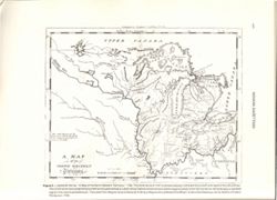
- S. Hill. sc. Map dated 1796. Relief shown by hachures and pictorially. Prime meridians: Philadelphia & London. "The dotted Squares, are the Reservations made by the Indians in their Treaty in 1795, and ceded to the United States." Also appears in: The American universal geography ... / by Jedidiah Morse. Boston : Isaiah Thomas and Ebenezer T. Andrews, 1796. "Figure 3.--Jediah Morse, A map of the North Western Territory, 1796. ... The name Fort Wayne honors General Anthony Wayne who defeated the Miami Indian Confederacy at the Battle of Fallen Timbers in 1794"--Caption. Appears as Figure 3 in Indiana Gazetteer produced by the U.S.G.S. Professional Paper 1200-I. "The National Gazetteer of the United States of America--Indiana 1988. Prepared by the U.S. Geological Survey in cooperation with the U.S. Board on Geographic names.
- Call Number
- QH75 .A4 No. 1200-IN
- Caption
- Imprint: [Reston, Va.] : [U.S. Gelogical Survey], [1988]
- Filename
- VAC3073-M-00979
- Subject
- Geographic Subject: Northwest, Old
- Geographic Subject: Northeastern States
- Title
- A map of the North Western Territory
- Producer
- Morse, Jedidiah, 1761-1826
- Hill, Samuel, approximately 1766-1804
- Thomas & Andrews
- Physical Description
- Scale: Scale not given.
- Dimensions: xxv, 477 p. : ill., maps, 29 cm.
- Item Identifiers
- Title Control Number: a18454609
- Alternate ID: 358171IP
- Persistent Identifier
- Campus
- IU Bloomington
- Date Created
- 1988
- Provenance
- The National gazetteer of the United States of America--Indiana, 1988 / U.S. Geological Survey.
- Publisher
- Geological Survey (U.S.)
Relationships
Relationships
- In Collection:
Items
Show Item Images
| Thumbnail | Title | Date Uploaded | Visibility | Actions |
|---|---|---|---|---|
|
VAC3073-M-00979.jp2 | 2023-09-27 | Public |
|