
Image
A road map of Monroe County Public Deposited
- Genre
- Road maps
- Location
- Coordinates: W0864107 W0861811 N0392126 N0385936
- Related URL
- Abstract
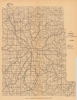
- Shows roads, improved roads, rural routes, rail roads, and road metal quarries. Alternate title: Illustrating the roads of Monroe County. At head of alternate title: Fig. 53C. Detached from: The roads and road materials of Monroe County / Charles W. Shannon. In Indiana Dept. of Geology and Natural Resources thirtieth annual report, 1905. Indianapolis: Wm. B. Burford, 1906. Page 95.
- Call Number
- G4093.M7P2 1905 .R6
- Caption
- Imprint: Indianapolis : 1906
- Filename
- VAC3073-M-00037
- Subject
- Topical Subject: Roads
- Topical Subject: IGS Annual Reports
- Geographic Subject: Monroe County (Ind.)
- Title
- A road map of Monroe County
- Physical Description
- Scale: Approximately 1:130,000
- Dimensions: 36 x 27 cm
- Item Identifiers
- Alternate ID: 390726IP
- Title Control Number: a18298783
- Persistent Identifier
- Campus
- IU Bloomington
- Date Created
- 1906
- Provenance
- 30th Annual Report (1905) / Indiana. Department of Geology and Natural Resources.
- Publisher
- Indiana. Department of Geology and Natural Resources
Relationships
Relationships
- In Collection:
Items
Show Item Images
| Thumbnail | Title | Date Uploaded | Visibility | Actions |
|---|---|---|---|---|
|
VAC3073-00223.jp2 | 2023-09-21 | Public |
|