
Image
O-36-102-Г Хитино 公开 Deposited
- Original Publication Date
1939
- Genre
- Topographic Maps
- Military Maps
- Location
- Coordinates: 57, 32.75, 57.167, 33
- Related URL
- Abstract
- Modern area represented: Хитино (Khitino), Тверская область (Tverskaya oblast), Russia
- Call Number
- GM G7000 s50 .S68 sheet O-36-102-D
- Caption
- Для служебного пользования
- City
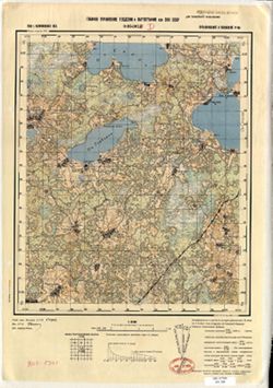
- Хитино (Khitino)
- Copyright Owner
- No Copyright - United States
- Country
- СССР (USSR)
- Filename
- VAC9619-002840
- Subject
- Topical Subject: Soviet Union
- Geographic Subject: Khitino
- Topical Subject: Maps
- State/Region
- Пеновский район (Penovsky district)
- Осташковский район (Ostashkovsky district)
- Калининская область (Kalinin oblast)
- Title
- O-36-102-Г Хитино
- Physical Description
- Scale: 1:50,000
- Language
- Russian
- Persistent Identifier
- Campus
- IU Bloomington
- Date Created
- 1941
- Provenance
- DMA Topographic Center, Army Map Service Library, OMAHA, Library of Congress Geography & Map Division, Geographic Names Branch
- Publisher
- Главное управление геодезии и картографии при СНК СССР
Relationships
关联
- 属于 Collection:
Items
Show Item Images
| 缩略图 | 标题 | 上传日期 | 公开度 | 行动 |
|---|---|---|---|---|
|
VAC9619-002840.jp2 | 2024-01-19 | 公开 |
|
|
VAC9619-U-002859.jp2 | 2024-01-19 | 公开 |
|