
Image
Bloomington, Indiana, land utilization of ten blocks Public Deposited
- Genre
- Thematic maps
- Location
- Coordinates: W0863206 W0863146 N0391000 N0390950
- Related URL
- Abstract
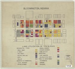
- Shows the area from the Monon Railroad on the west to Grant Street on the east, and from Fifth Street on the north to Third Street on the South. Pen-and-ink and colored pencil, on tracing paper.
- Call Number
- G4094.B5 G4 1950 .B5
- Caption
- Imprint: [Place of publication not identified] : [publisher not identified], [195-?]
- Filename
- VAC3073-M-00589
- Subject
- Topical Subject: Land use
- Geographic Subject: Bloomington (Ind.)
- Title
- Bloomington, Indiana, land utilization of ten blocks
- Physical Description
- Scale: Scale not given.
- Dimensions: 47 x 52 cm
- Item Identifiers
- Title Control Number: a5299843
- Persistent Identifier
- Campus
- IU Bloomington
- Date Created
- 1950
- Publisher
- [publisher not identified]
Relationships
Relationships
- In Collection:
Items
Show Item Images
| Thumbnail | Title | Date Uploaded | Visibility | Actions |
|---|---|---|---|---|
|
VAC3073-M-00589.jp2 | 2023-09-25 | Public |
|