
Image
1952 state highway system of Indiana Público Deposited
- Genre
- Road maps
- Location
- Coordinates: W0880500 W0844700 N0414500 N0374600
- Related URL
- Abstract
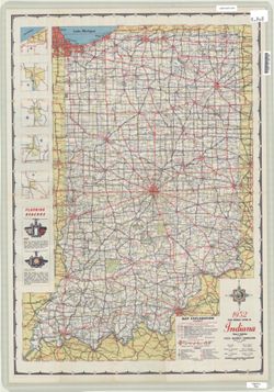
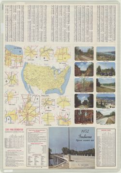
- Panel title: 1952 Indiana official highway map. Relief shown by spot heights. Includes text, color illustrations, and 5 local route maps. Index, distance chart, distance map of the United States, table of state park information, directory of state police posts and garages, color illustrations, and 12 local route maps on verso.
- Call Number
- G1403 .S7 1952
- Caption
- Imprint: [Indianapolis] : State Highway Commission, [1952]
- Filename
- VAC3073-M-01222
- Subject
- Geographic Subject: Indiana
- Topical Subject: Roads
- Title
- 1952 state highway system of Indiana
- Producer
- Indiana. State Highway Commission (1919-1953)
- Physical Description
- Dimensions: 94 x 59 cm
- Scale: Approximately 1:633,600
- Item Identifiers
- Title Control Number: a18406078
- Persistent Identifier
- Campus
- IU Bloomington
- Date Created
- 1952
- Provenance
- Indiana state highway system
- Publisher
- Indiana. State Highway Commission (1919-1953)
Relationships
Relaciones
- En Collection:
Items
Show Item Images
| Miniatura | Título | Fecha de subida | Visibilidad | Acciones |
|---|---|---|---|---|
|
VAC3073-M-01222.jp2 | 2023-09-27 | Público |
|
|
VAC3073-00576.jp2 | 2023-09-27 | Público |
|