
Image
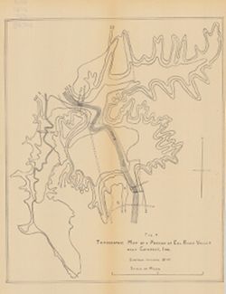
Topographic map of a portion of Eel River Valley near Cataract, Ind. Public Deposited
- Genre
- Topographic maps
- Location
- Coordinates: W0865003 W0864726 N0392725 N0392513
- Related URL
- Abstract
- Relief shown by contours. Contour interval 20 feet. Shows upper falls dam and proposed lower falls dams now located within the Cataract Falls State Recreation Area in Owen County, Indiana. At head of title: "Fig. 7." Detached from: Water power of Indiana / W.M. Tucker. In Indiana Departmen of Geology and Natural Resources thirty-fifth annual report, 1910. Indianapolis: Wm. B. Burford, 1911. Page 66.
- Call Number
- G4092.O8C2 1910 .T6
- Caption
- Imprint: [Indianapolis] : [Wm. B. Burford], [1911]
- Imprint: [Indianapolis] : [Indiana Department of Geology and Natural Resources], [1911]
- Filename
- VAC3073-M-00830
- Subject
- Geographic Subject: Owen County (Ind.)
- Geographic Subject: Eel River Valley (Ind. : Valley)
- Topical Subject: IGS Annual Reports
- Topical Subject: Valleys
- Title
- Topographic map of a portion of Eel River Valley near Cataract, Ind.
- Physical Description
- Scale: Approximately 1:7,650
- Dimensions: 31 x 25 cm
- Item Identifiers
- Title Control Number: a18418393
- Alternate ID: 390726IP
- Persistent Identifier
- Campus
- IU Bloomington
- Date Created
- 1911
- Provenance
- 35th Annual Report (1910) / Indiana. Department of Geology and Natural Resources.
- Publisher
- Indiana. Department of Geology and Natural Resources
Relationships
Relationships
- In Collection:
Items
Show Item Images
| Thumbnail | Title | Date Uploaded | Visibility | Actions |
|---|---|---|---|---|
|
VAC3073-00091.jp2 | 2023-09-27 | Public |
|