
Image
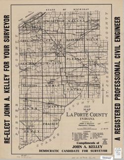
1937 map of LaPorte County Indiana Public Deposited
- Genre
- Maps
- Location
- Coordinates: W0865600 W0862910 N0414539 N0411412
- Related URL
- Abstract
- "Compliments of John A. Kelley, Democratic Candidate for Surveyor."
- Call Number
- G4093.L15 1936 .K45
- Caption
- Imprint: [Michigan City, Ind.] : [John A. Kelley?], 1936.
- Filename
- VAC3073-M-00566
- Subject
- Geographic Subject: LaPorte County (Ind.)
- Title
- 1937 map of LaPorte County Indiana
- Producer
- Kelley, John A., C.E.
- Physical Description
- Scale: 1:120,000
- Dimensions: 53 x 36 cm
- Item Identifiers
- Title Control Number: a6083265
- Persistent Identifier
- Campus
- IU Bloomington
- Date Created
- 1936
- Publisher
- [John A. Kelley?]
Relationships
Relationships
- In Collection:
Items
Show Item Images
| Thumbnail | Title | Date Uploaded | Visibility | Actions |
|---|---|---|---|---|
|
VAC3073-00148.jp2 | 2023-09-25 | Public |
|