
Image
1972-73 Indiana state highway system Public Deposited
- Genre
- Road maps
- Location
- Coordinates: W0880500 W0844700 N0414500 N0374600
- Related URL
- Abstract
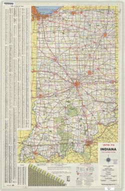
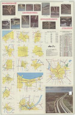
- Panel title: 1972-73 Indiana official highway map. Relief shown by spot heights. Includes index, distance chart, and text. Indexed chart of state recreation sites and facilities, directory of state police posts, text, 15 local route maps, and col. ill. of highway interchanges on verso.
- Call Number
- G1403 .S7 1972-1973
- Caption
- Imprint: [Indianapolis] : State Highway Commission, [1972]
- Filename
- VAC3073-M-01202
- Subject
- Geographic Subject: Indiana
- Topical Subject: Roads
- Title
- 1972-73 Indiana state highway system
- Producer
- Indiana. State Highway Commission (1961-1981). Division of Planning
- Physical Description
- Dimensions: 94 x 59 cm
- Scale: Approximately 1:633,600
- Item Identifiers
- Title Control Number: a18405992
- Persistent Identifier
- Campus
- IU Bloomington
- Date Created
- 1972
- Provenance
- Indiana state highway system
- Publisher
- Indiana. State Highway Commission (1961-1981). Division of Planning
Relationships
Des relations
- Dans Collection:
Items
Show Item Images
| La vignette | Titre | Date de téléchargement | Visibilité | actes |
|---|---|---|---|---|
|
VAC3073-M-01202.jp2 | 2023-09-27 | Public |
|
|
VAC3073-00556.jp2 | 2023-09-27 | Public |
|