
Image
Distribution, structure, and mined areas of coals in Fountain and Warren Counties and the northermost part of Vermillion County, Indiana Öffentlichkeit Deposited
- Genre
- Mine maps
- Location
- Coordinates: W0873200 W0870533 N0402800 N0395645
- Related URL
- Abstract
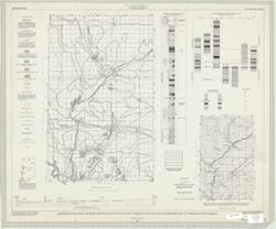
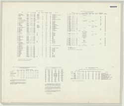
- "Preliminary coal map no. 9"--Margin. Includes 1 ancillary map, 1 diagram showing township enumeration, 1 index map, 1 stratigraphic column, and 1 cross section. Verso shows 5 tables including indexed list of mines keyed to map.
- Call Number
- G4093.F6H9 1961 .H88
- Caption
- Imprint: Bloomington : Indiana Dept. of Conservation, Geological Survey, 1961.
- Filename
- VAC3073-M-00418
- Subject
- Geographic Subject: Warren County (Ind.)
- Topical Subject: Coal mines and mining
- Geographic Subject: Vermillion County (Ind.)
- Geographic Subject: Fountain County (Ind.)
- Title
- Distribution, structure, and mined areas of coals in Fountain and Warren Counties and the northermost part of Vermillion County, Indiana
- Producer
- Hutchison, Harold C. (Harold Christy), 1925-
- Physical Description
- Scale: Scales differ.
- Dimensions: 61 x 72 cm
- Item Identifiers
- Title Control Number: a4898738
- Persistent Identifier
- Campus
- IU Bloomington
- Date Created
- 1961
- Publisher
- Indiana. Geological Survey
Relationships
Beziehungen
- In Collection:
Items
Show Item Images
| Miniaturansicht | Titel | Datum Hochgeladen | Sichtbarkeit | Aktionen |
|---|---|---|---|---|
|
VAC3073-M-00418.jp2 | 2023-09-25 | Öffentlichkeit |
|
|
VAC3073-00510.jp2 | 2023-09-25 | Öffentlichkeit |
|