
Image
Indianapolis Public Deposited
- Genre
- Maps
- Location
- Coordinates: W0861941 W0855614 N0395538 N0393755
- Related URL
- Abstract
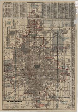
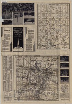
- Includes street index and inset of the Nora area (scale [ca. 1:39,000]) On verso: map of "Marion County, Indiana" with indexes to streets and roads, towns and communities, townships, parks, golf and country clubs, and miscellaneous locations, Cram's map of the central business district of Indianapolis showing hotels, theatres, office buildings, etc. (scale [ca. 1:9,000]), location and distance map, and ill.
- Call Number
- G4094 .I4 1945 .G46
- Caption
- Imprint: Indianapolis : The Company, [1945]
- Filename
- VAC3073-M-00843
- Subject
- Geographic Subject: Marion County (Ind.)
- Geographic Subject: Indianapolis (Ind.)
- Title
- Indianapolis
- Producer
- George F. Cram Company
- Physical Description
- Dimensions: 75 x 56 cm
- Scale: 1:28,000
- Item Identifiers
- Title Control Number: a5044759
- Persistent Identifier
- Campus
- IU Bloomington
- Date Created
- 1945
- Publisher
- George F. Cram Company
Relationships
Relationships
- In Collection:
Items
Show Item Images
| Thumbnail | Title | Date Uploaded | Visibility | Actions |
|---|---|---|---|---|
|
VAC3073-M-00843.jp2 | 2023-09-27 | Public |
|
|
VAC3073-00387.jp2 | 2023-09-27 | Public |
|