
Image
State highway system of Indiana [1932] Público Deposited
- Genre
- Road maps
- Location
- Coordinates: W0880500 W0844700 N0414500 N0374600
- Related URL
- Abstract
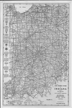
- Shows roads by surface and composition type as well as standard Indiana road signs and the locations of state parks, state owned property, bodies of water, points of interest, bridges, ferries, and the Purdue University Experimental Farm. "Sept. 30, 1932." "Plate II." Detached from: Report of the Indiana State Highway Commission for the fiscal year ending September 30, 1932 / State Highway Commission. In Year book of the State of Indiana for 1932 / The Legislative Reference Bureau. Indianapolis : Wm. B. Burford, contractor for state printing and binding, 1933.
- Call Number
- G4091.P2 1932 .I5
- Caption
- Imprint: [Indianapolis] : [Wm. B. Burford, contractor for state printing and binding], [1933]
- Imprint: [Indianapolis] : [The Legislative Bureau], [1933]
- Filename
- VAC3073-M-01044
- Subject
- Geographic Subject: Indiana
- Topical Subject: Road materials
- Topical Subject: Roads
- Title
- State highway system of Indiana [1932]
- Producer
- Indiana. State Highway Commission (1919-1953)
- Physical Description
- Dimensions: 41 x 27, on sheet 44 x 29 cm
- Scale: Approximately 1:1,200,000
- Item Identifiers
- Alternate ID: 397754IP
- Title Control Number: a18422897
- Persistent Identifier
- Campus
- IU Bloomington
- Date Created
- 1933
- Provenance
- Year book of the state of Indiana (1932)
- Publisher
- Indiana. Legislative Bureau
Relationships
Relaciones
- En Collection:
Items
Show Item Images
| Miniatura | Título | Fecha de subida | Visibilidad | Acciones |
|---|---|---|---|---|
|
VAC3073-00306.jp2 | 2023-09-27 | Público |
|