
Image
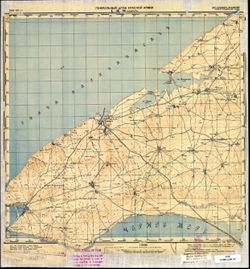
L-36-90 Ак-Мечеть 公开 Deposited
- Original Publication Date
1898
- Genre
- Military Maps
- Topographic Maps
- Location
- Coordinates: 45.3333, 32.5, 45.6667, 33
- Related URL
- Abstract
- Modern area represented: Черноморское (Chernomorskoye), Republic of Crimea, Ukraine
- Call Number
- G7000 s100 .S7 sheet L-36-90
- Caption
- Для cлужебного пользования
- City
- Ак-Мечеть (Ak-Mechetʹ)
- Copyright Owner
- No Copyright - United States
- Country
- СССР (USSR)
- Filename
- VAC9619-001947
- Subject
- Geographic Subject: Chernomorskoye
- Topical Subject: Maps
- Topical Subject: Soviet Union
- Geographic Subject: Republic of Crimea
- State/Region
- Крымская АССР (Crimean Autonomous Soviet Socialist Republic)
- РСФСР (RSFSR)
- Title
- L-36-90 Ак-Мечеть
- Physical Description
- Scale: 1:100,000
- Language
- Russian
- Persistent Identifier
- Campus
- IU Bloomington
- Date Created
- 1941
- Provenance
- DMA Topographic Center
- Publisher
- Генеральный штаб Красной Армии
Relationships
关联
- 属于 Collection:
Items
Show Item Images
| 缩略图 | 标题 | 上传日期 | 公开度 | 行动 |
|---|---|---|---|---|
|
VAC9619-001947.jp2 | 2024-01-08 | 公开 |
|
|
VAC9619-U-000378.jp2 | 2024-01-08 | 公开 |
|