
Image
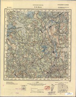
M-35-20 Юрово Public Deposited
- Original Publication Date
1916
- Genre
- Topographic Maps
- Military Maps
- Location
- Coordinates: 51.333, 27.5, 51.667, 28
- Related URL
- Abstract
- Modern area represented: Yurove, Zhytomyr oblast, Ukraine
- Call Number
- G7000 s100 .S7 sheet M-35-20
- Caption
- Не подлежит оглашению
- City
- Юрово (Yurovo)
- Copyright Owner
- No Copyright - United States
- Country
- СССР (USSR)
- Filename
- VAC9619-003052
- Subject
- Geographic Subject: Yurove
- Topical Subject: Maps
- Topical Subject: Soviet Union
- State/Region
- Полесская область (Polesia oblast)
- Белорусская ССР (Byelorussian Soviet Socialist Republic)
- Ровенская область (Rivne oblast)
- Житомирская область (Zhytomyr oblast)
- Украинская ССР (Ukrainian Soviet Socialist Republic)
- Title
- M-35-20 Юрово
- Physical Description
- Scale: 1:100,000
- Language
- Russian
- Persistent Identifier
- Campus
- IU Bloomington
- Date Created
- 1938
- Provenance
- DMA Topographic Center, Army Map Service Library, OMAHA, Library of Congress Geography & Map Division
- Publisher
- Генеральный штаб РККА
Relationships
Relationships
- In Collection:
Items
Show Item Images
| Thumbnail | Title | Date Uploaded | Visibility | Actions |
|---|---|---|---|---|
|
VAC9619-003052.jp2 | 2024-01-23 | Public |
|
|
VAC9619-U-003301.jp2 | 2024-01-23 | Public |
|