
Image
[Northeastern Indiana lake district] Public Deposited
- Genre
- Maps
- Location
- Coordinates: W0860140 W0844748 N0414530 N0410328
- Related URL
- Abstract
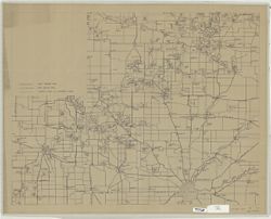
- Blue line. Title supplied by cataloger. Covers an area from the Michigan state line on the north, Fort Wayne on the south, Atwood, Ind. on the west and the Ohio state line on the east.
- Call Number
- G4090 1934 .M35
- Caption
- Imprint: [Place of publication not identified] : [publisher not identified], [1934]
- Filename
- VAC3073-M-01287
- Subject
- Geographic Subject: Indiana
- Title
- [Northeastern Indiana lake district]
- Producer
- McKean, Hugh K.
- Physical Description
- Dimensions: 68 x 81 cm
- Scale: Scale not given.
- Persistent Identifier
- Campus
- IU Bloomington
- Date Created
- 1934
- Publisher
- [publisher not identified]
Relationships
Relationships
- In Collection:
Items
Show Item Images
| Thumbnail | Title | Date Uploaded | Visibility | Actions |
|---|---|---|---|---|
|
VAC3073-M-01287.jp2 | 2023-09-28 | Public |
|