
Image
Geologic map of Indiana Public Deposited
- Genre
- Geological maps
- Location
- Coordinates: W0880000 W0844500 N0414500 N0375200
- Related URL
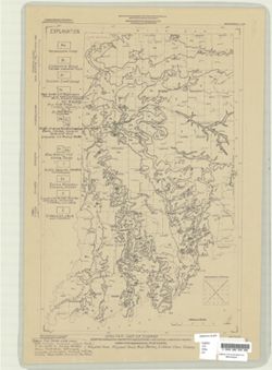
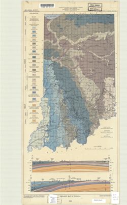
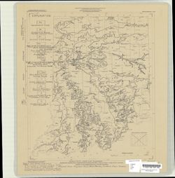
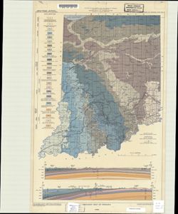
- Abstract
- "Base from Map of Indiana, 1950 edition, published by the U.S. Geological Survey. Minor revisions and additions made from Indiana Department of Conservation, Geological Survey, county base maps." Includes 2 color cross-sections and notes.
- Call Number
- G4091 .C5 1956 .P3
- Caption
- Imprint: [Bloomington] : Indiana Geological Survey, 1956.
- Filename
- VAC3073-M-00212
- Subject
- Topical Subject: Geology
- Geographic Subject: Indiana
- Title
- Geologic map of Indiana
- Producer
- Patton, John B. (John Barratt), 1915-
- Physical Description
- Dimensions: 59 x 31 cm
- Scale: 1:1,000,000
- Item Identifiers
- Title Control Number: a5888483
- Persistent Identifier
- Campus
- IU Bloomington
- Date Created
- 1956
- Publisher
- Indiana. Geological Survey
Relationships
Relationships
- In Collection:
Items
Show Item Images
| Thumbnail | Title | Date Uploaded | Visibility | Actions |
|---|---|---|---|---|
|
VAC3073-M-00212.jp2 | 2023-09-22 | Public |
|
|
VAC3073-00461.jp2 | 2023-09-22 | Public |
|
|
VAC3073-00909.jp2 | 2023-09-22 | Public |
|
|
VAC3073-00910.jp2 | 2023-09-22 | Public |
|