
Image
N-36-100 Самотевичи Público Deposited
- Original Publication Date
1928
- Genre
- Topographic Maps
- Military Maps
- Location
- Coordinates: 53, 31.5, 53.333, 32
- Related URL
- Abstract
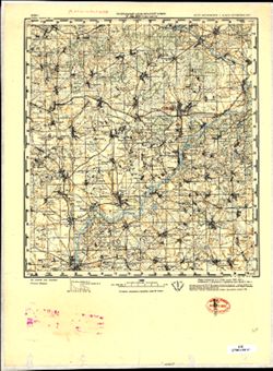
- Modern area represented: Samotevichi, Mogilev oblast, Belarus
- Call Number
- G7000 s100 .S7 sheet N-36-100
- City
- Самотевичи (Samotevichi)
- Copyright Owner
- No Copyright - United States
- Country
- СССР (USSR)
- Filename
- VAC9619-001976
- Subject
- Topical Subject: Maps
- Geographic Subject: Samotevichi
- Topical Subject: Soviet Union
- State/Region
- Орловская область (Oryol oblast)
- Белорусская ССР (Byelorussian Soviet Socialist Republic)
- РСФСР (RSFSR)
- Могилевская область (Mogilev oblast)
- Title
- N-36-100 Самотевичи
- Physical Description
- Scale: 1:100,000
- Language
- Russian
- Persistent Identifier
- Campus
- IU Bloomington
- Date Created
- 1941
- Provenance
- DMA Topographic Center, Army Map Service Library, OMAHA, Atlasblatt, Library of Congress Geography & Map Division
- Publisher
- Генеральный штаб Красной Армии
Relationships
Relaciones
- En Collection:
Items
Show Item Images
| Miniatura | Título | Fecha de subida | Visibilidad | Acciones |
|---|---|---|---|---|
|
VAC9619-001976.jp2 | 2024-01-08 | Público |
|
|
VAC9619-U-000364.jp2 | 2024-01-08 | Público |
|