
Image
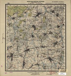
N-36-101-В Струговская Буда Public Deposited
- Original Publication Date
1928
- Genre
- Topographic Maps
- Military Maps
- Location
- Coordinates: 53, 32, 53.1667, 32.25
- Related URL
- Abstract
- Modern area represented: Strugovskaya Buda, Bryansk oblast, Russia
- Call Number
- G7000 s50 .S68 sheet N-36-101-В
- Caption
- Не подлежит оглашению
- City
- Струговская Буда (Strugovskaya Buda)
- Copyright Owner
- No Copyright - United States
- Country
- СССР (USSR)
- Filename
- VAC9619-001499
- Subject
- Geographic Subject: Strugovskaya Buda
- Topical Subject: Maps
- Topical Subject: Soviet Union
- State/Region
- Западная область (Western oblast)
- Белорусская ССР (Byelorussian Soviet Socialist Republic)
- РСФСР (RSFSR)
- Title
- N-36-101-В Струговская Буда
- Physical Description
- Scale: 1:50,000
- Language
- Russian
- Persistent Identifier
- Campus
- IU Bloomington
- Provenance
- Army Map Service Library, Library of Congress Geography & Map Division, OMAHA
- Publisher
- Военно-топографическое управление
Relationships
Relationships
- In Collection:
Items
Show Item Images
| Thumbnail | Title | Date Uploaded | Visibility | Actions |
|---|---|---|---|---|
|
VAC9619-001499.jp2 | 2024-02-27 | Public |
|
|
VAC9619-U-000406.jp2 | 2024-02-27 | Public |
|