
Image
State forests Public Deposited
- Genre
- Tourist maps
- Thematic maps
- Location
- Coordinates: W0880610 W0844655 N0393200 N0374600
- Related URL
- Abstract
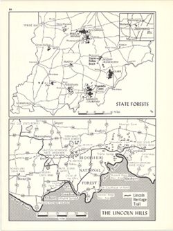
- 2 maps on 1 sheet, State Forests and The Lincoln Hills. Lincoln Hills map (1:690,000) shows Lincoln Heritage Trail, various Lincoln-related sites and other natural and cultural resources in Harrison, Crawford, Perry, and Spencer counties along the southern border of Indiana. Detached from: An atlas of Indiana / by Robert C. Kingsbury , with contributions from John M. Hollingsworth and others. Bloomington, Indiana : Department of Geography, Indiana University, [1970]. Page 84.
- Call Number
- G4091.K2 1970 .K56
- Caption
- Imprint: Bloomington, Indiana : Department of Geography, Indiana University, [1970]
- Filename
- VAC3073-M-00668
- Subject
- Topical Subject: Forest reserves
- Geographic Subject: Indiana
- Geographic Subject: Lincoln Hills Resource Conservation and Development Project Area (Ind.)
- Topical Subject: Outdoor recreation
- Title
- State forests
- Producer
- Hollingsworth, John M.
- Kingsbury, Robert C.
- Physical Description
- Scale: Approximately 1:1,600,000
- Dimensions: each 13 x 18 cm, on sheet 28 x 21 cm
- Item Identifiers
- Alternate ID: 317383IP
- Title Control Number: a15938315
- Persistent Identifier
- Campus
- IU Bloomington
- Date Created
- 1970
- Provenance
- An atlas of Indiana / by Robert C. Kingsbury [1970].
- Publisher
- Indiana University. Department of Geography
Relationships
Relationships
- In Collection:
Items
Show Item Images
| Thumbnail | Title | Date Uploaded | Visibility | Actions |
|---|---|---|---|---|
|
VAC3073-M-00668.jp2 | 2023-09-25 | Public |
|