
Image
N-34-19-A-а Бэреншлухт Öffentlichkeit Deposited
- Original Publication Date
1910
- Genre
- Military Maps
- Topographic Maps
- Location
- Coordinates: 55.583, 21, 55.667, 21.125
- Related URL
- Abstract
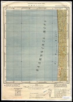
- Modern area represented: Meškų Dauba, Lithuania
- Call Number
- G7063.K2 s25 .S6 sheet N-34-19-A-a
- City
- Бэреншлухт (Berenshlukht)
- Copyright Owner
- No Copyright - United States
- Country
- Германия (Germany)
- Восточная Пруссия (East Prussia)
- Filename
- VAC9619-003574
- Subject
- Topical Subject: Soviet Union
- Geographic Subject: Meškų Dauba
- Topical Subject: Maps
- Title
- N-34-19-A-а Бэреншлухт
- Physical Description
- Scale: 1:25,000
- Language
- Russian
- Persistent Identifier
- Campus
- IU Bloomington
- Date Created
- 1940
- Provenance
- DMA Topographic Center, Army Map Service Library, Library of Congress Geography & Map Division
- Publisher
- Генеральный штаб Красной Армии
Relationships
Beziehungen
- In Collection:
Items
Show Item Images
| Miniaturansicht | Titel | Datum Hochgeladen | Sichtbarkeit | Aktionen |
|---|---|---|---|---|
|
VAC9619-003574.jp2 | 2024-02-08 | Öffentlichkeit |
|
|
VAC9619-U-003901.jp2 | 2024-02-08 | Öffentlichkeit |
|