
Image
Switzerland County [Indiana] preliminary land use map Public Deposited
- Genre
- Thematic maps
- Location
- Coordinates: W0851212 W0844704 N0385546 N0384114
- Related URL
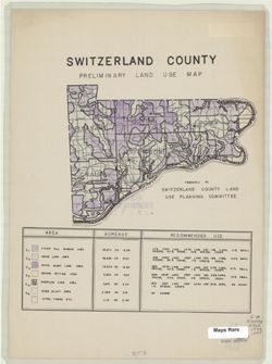
- Abstract
- Includes chart showing type of land use, acreage, and recommended use.
- Call Number
- G4093.S9 1940 .S95
- Caption
- Imprint: [Vevay, Ind.?] : The Committee, [1940?]
- Filename
- VAC3073-M-00661
- Subject
- Geographic Subject: Switzerland County (Ind.)
- Topical Subject: Land use
- Title
- Switzerland County [Indiana] preliminary land use map
- Producer
- Switzerland County (Ind.). Land Use Planning Committee
- Physical Description
- Dimensions: 21 x 16 cm, on sheet 39 x 28 cm
- Scale: Scale not given.
- Item Identifiers
- Title Control Number: a5126605
- Persistent Identifier
- Campus
- IU Bloomington
- Date Created
- 1940
- Publisher
- Switzerland County (Ind.). Land Use Planning Committee
Relationships
Relationships
- In Collection:
Items
Show Item Images
| Thumbnail | Title | Date Uploaded | Visibility | Actions |
|---|---|---|---|---|
|
VAC3073-M-00661.jp2 | 2023-09-25 | Public |
|