
Image
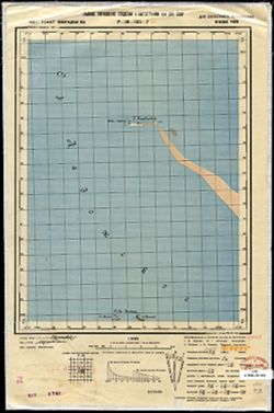
P-36-135-Г Público Deposited
- Original Publication Date
1939
- Genre
- Military Maps
- Topographic Maps
- Location
- Coordinates: 60, 31.25, 60.167, 31.5
- Related URL
- Abstract
- Modern area represented: остров Кареджи (ostrov Karedzhi)
- Call Number
- GM G7000 s50 .S68 sheet P-36-135-D
- Caption
- Для служебного пользования
- City
- остров Кареджский (ostrov Karedzhskiy)
- Copyright Owner
- No Copyright - United States
- Country
- СССР (USSR)
- Filename
- VAC9619-002952
- Subject
- Topical Subject: Soviet Union
- Geographic Subject: ostrov Karedzhi
- Topical Subject: Maps
- State/Region
- Ленинградская область (Leningrad oblast)
- РСФСР (RSFSR)
- Мгинский район (Mginsky district)
- Title
- P-36-135-Г
- Physical Description
- Scale: 1:50,000
- Language
- Russian
- Persistent Identifier
- Campus
- IU Bloomington
- Date Created
- 1941
- Provenance
- DMA Topographic Center, Army Map Service Library, OMAHA, Library of Congress Geography & Map Division
- Publisher
- Главное управление геодезии и картографии при СНК СССР
Relationships
Relaciones
- En Collection:
Items
Show Item Images
| Miniatura | Título | Fecha de subida | Visibilidad | Acciones |
|---|---|---|---|---|
|
VAC9619-002952.jp2 | 2024-01-23 | Público |
|
|
VAC9619-U-003125.jp2 | 2024-01-23 | Público |
|