
Image
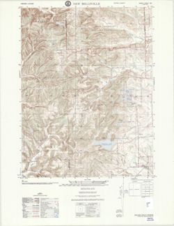
New Bellsville : Indiana 1:25,000 Public Deposited
- Genre
- Topographic maps
- 7.5 minute topographic maps
- Quadrangle maps
- Location
- Coordinates: W0860730 W0860000 N0391500 N0390730
- Related URL
- Abstract
- Printed with vegetation. Prepared by the Defense Mapping Agency Topographic Center. Variant title: Indiana 1:25,000. Filing title: New Bellsville, Indiana. Standard map series designation: AMS (Series) V851 Sheet 3762 II NE. Edition 3-DMATC. "D.M.A. Series V851" Transverse Mercator projection. Relief shown by contours and spot heights. Shows roads, railroads, boundaries, buildings, and natural features. "Contour interval 10 feet." Marginal maps: Index to boundaries.--Index to adjoining sheets. "Copied in 1975 from Indiana 1:24,000 U. S. G. S., New Bellsville, 1962. Scale changed and marginal data revised, 1975." "Stock No. V851X37622NE*03." "12-75."
- Call Number
- G4090 s25 .U5 New Bellsville 1975 V
- Caption
- Imprint: Washington, D.C. : Defense Mapping Agency Topographic Center, [1975]
- Filename
- VAC3073-M-01440
- Subject
- Geographic Subject: Bartholomew County (Ind.)
- Geographic Subject: Brown County (Ind.)
- Title
- New Bellsville : Indiana 1:25,000
- Producer
- United States. Defense Mapping Agency. Topographic Center
- Geological Survey (U.S.)
- Physical Description
- Dimensions: 56 x 45 cm or smaller
- Scale: 1:25,000
- Item Identifiers
- Title Control Number: a18376551
- Persistent Identifier
- Campus
- IU Bloomington
- Date Created
- 1975
- Provenance
- Part of United States. Army Map Service, Indiana 1:25,000.
- Publisher
- United States. Army Map Service
Relationships
Relationships
- In Collection:
Items
Show Item Images
| Thumbnail | Title | Date Uploaded | Visibility | Actions |
|---|---|---|---|---|
|
VAC3073-M-01440.jp2 | 2023-09-28 | Public |
|