
Image
Urban population change, 1910-1960 Público Deposited
- Genre
- Thematic maps
- Location
- Coordinates: W0880700 W0844500 N0414500 N0374600
- Related URL
- Abstract
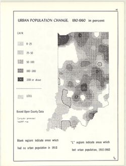
- Computer generated isopleth map obtained through use of the facilities of Indiana University's Research Computer Center. ASCII-art map created using SYMAP or similar technique. Detached from: An atlas of Indiana / by Robert C. Kingsbury , with contributions from John M. Hollingsworth and others. Bloomington, Indiana : Department of Geography, Indiana University, [1970]. Page 43.
- Call Number
- G4091.E2 1960 .K52
- Caption
- Imprint: Bloomington, Indiana : Department of Geography, Indiana University, [1970]
- Filename
- VAC3073-M-00926
- Subject
- Topical Subject: Population geography
- Topical Subject: Historical geography
- Topical Subject: SYMAP (Computer program language)
- Geographic Subject: Indiana
- Topical Subject: City dwellers
- Title
- Urban population change, 1910-1960
- Producer
- Hollingsworth, John M.
- Indiana University. Research Computing Center
- Kingsbury, Robert C.
- Physical Description
- Dimensions: 26 x 18 cm, on sheet 28 x 21 cm
- Scale: Approximately 1:2,500,000
- Item Identifiers
- Alternate ID: 317383IP
- Title Control Number: a15948261
- Persistent Identifier
- Campus
- IU Bloomington
- Date Created
- 1970
- Provenance
- An atlas of Indiana / by Robert C. Kingsbury [1970].
- Publisher
- Indiana University. Department of Geography
Relationships
Relaciones
- En Collection:
Items
Show Item Images
| Miniatura | Título | Fecha de subida | Visibilidad | Acciones |
|---|---|---|---|---|
|
VAC3073-M-00926.jp2 | 2023-09-27 | Público |
|