
Image
Indiana (Lake County) Toleston quadrangle [sic] [1925 reprint] Öffentlichkeit Deposited
- Genre
- Quadrangle maps
- 15 minute topographic maps
- Topographic maps
- Location
- Coordinates: W0873000 W0871500 N0414500 N0413000
- Related URL
- Abstract
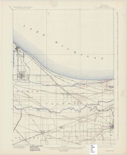
- United States, Department of the Interior, Geological Survey , Jno. H. Renshawe, geographer in charge , control by U.S. Lake Survey , topography by R. C. McKinney. Filing title: Tolleston, Ind. Edition of Oct. 1900. Polyconic projection. Relief shown by contours and spot heights, depths shown by isolines and soundings. Contour interval 10 feet. Surveyed in 1897. Reprinted Feb. 1909, 1916, 1925, 1939, and 1951. Correction of misspelling of "Toleston" to "Tolleston" in titles made by 1939 reprinting. "(Dyer) 1:24,000." "N4130-W8715/15."
- Call Number
- G4090 s62 .G4 Toleston 1900 rep1925
- Caption
- Imprint: Washington, D. C. : United States, Department of the Interior, Geological Survey, 1925
- Filename
- VAC3073-M-01399
- Subject
- Geographic Subject: Lake County (Ind.)
- Title
- Indiana (Lake County) Toleston quadrangle [sic] [1925 reprint]
- Producer
- Geological Survey (U.S.)
- U.S. Lake Survey
- Renshawe, John H.
- McKinney, R. C. (Robert C.)
- Physical Description
- Scale: 1:62,500
- Dimensions: 45 x 42 cm or smaller
- Item Identifiers
- Title Control Number: a18406229
- Persistent Identifier
- Campus
- IU Bloomington
- Date Created
- 1925
- Provenance
- Part of Geological Survey (U.S.). Indiana 1:62,500.
- Publisher
- Geological Survey (U.S.)
Relationships
Beziehungen
- In Collection:
Items
Show Item Images
| Miniaturansicht | Titel | Datum Hochgeladen | Sichtbarkeit | Aktionen |
|---|---|---|---|---|
|
VAC3073-M-01399.jp2 | 2023-09-28 | Öffentlichkeit |
|