
Image
Monroe County, Indiana, existing use of land. Sheet 1 [Index map] Pubblico Deposited
- Genre
- Index maps
- Location
- Coordinates: W0864100 W0861900 N0392100 N0390000
- Related URL
- Abstract
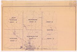
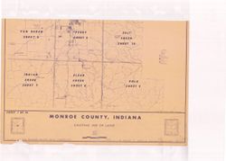
- Prepared for the Monroe County Plan Commission by Kenneth L. Schellie & Associates. "Land use survey taken June 1961". Includes locator and index maps. Sheet 1 of 14. Sheet 2. Bloomington -- Sheet 3. Perry -- Sheet 4. Bean Blossom -- Sheet 5. Richland -- Sheet 6. Van Buren -- Sheet 7. Indian Creek -- Sheet 8. Clear Creek -- Sheet 9. Polk -- Sheet 10. Salt Creek -- Sheet 11. Benton -- Sheet 12. Benton -- Sheet 13. Washington -- [Sheet 14. Unincorporated areas].
- Call Number
- G4093.M7A43 1987 .N38 sheet 1
- Caption
- Imprint: [Bloomington, Indiana] : Monroe County Plan Commission, 1961
- Filename
- VAC3073-M-01103
- Subject
- Topical Subject: Land use
- Geographic Subject: Monroe County (Ind.)
- Title
- Monroe County, Indiana, existing use of land. Sheet 1 [Index map]
- Producer
- Schellie Associates
- Physical Description
- Dimensions: 111 x 88 cm, on sheet 144 x 105 cm
- Scale: Approximately 1:36,864
- Item Identifiers
- Title Control Number: a18506950
- Persistent Identifier
- Campus
- IU Bloomington
- Date Created
- 1961
- Provenance
- Monroe County, Indiana, Existing Use of Land
- Publisher
- Schellie Associates
Relationships
Le relazioni
- In Collection:
Items
Show Item Images
| Thumbnail | Titolo | Data caricata | Visibilità | Azioni |
|---|---|---|---|---|
|
VAC3073-M-01103.jp2 | 2023-09-27 | Pubblico |
|
|
VAC3073-00399.jp2 | 2023-09-27 | Pubblico |
|