
Image
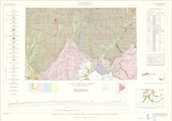
Geologic map of the 1° x 2° Cincinnati Quadrangle, Indiana and Ohio, showing bedrock and unconsolidated deposits Public Deposited
- Genre
- Geological maps
- Geological cross-sections
- Quadrangle maps
- Location
- Coordinates: W0860000 W0840000 N0400000 N0390000
- Related URL
- Abstract
- By Henry H. Gray, Jane L. Forsyth, Allan F. Schneider, and Ansel M. Gooding. Transverse Mercator projection. "Base map modified from Army Map Service, Map NJ 16-3, 1964." Includes text, cross section, columnar section, diagram, schematic section, ancillary map, and index map.
- Call Number
- G4091 .C5 1972 .G455
- Caption
- Imprint: [Bloomington, Ind.] : Indiana Geological Survey, 1972
- Filename
- VAC3073-M-01245
- Subject
- Geographic Subject: Indiana
- Topical Subject: Geology, Stratigraphic
- Geographic Subject: Ohio
- Topical Subject: Geology
- Title
- Geologic map of the 1° x 2° Cincinnati Quadrangle, Indiana and Ohio, showing bedrock and unconsolidated deposits
- Producer
- Schneider, Allan F. (Allan Frank), 1926-
- Gooding, Ansel Miller
- Forsyth, Jane L. (Jane Louise), 1921-
- Gray, Henry Hamilton, 1922-
- Indiana. Geological Survey
- Physical Description
- Dimensions: 73 x 66 cm
- Scale: 1:250,000
- Item Identifiers
- Title Control Number: a16799790
- Persistent Identifier
- Campus
- IU Bloomington
- Date Created
- 1972
- Provenance
- Indiana. Geological Survey. Regional geologic map , no. 7.
- Publisher
- Indiana. Geological Survey
Relationships
Des relations
- Dans Collection:
Items
Show Item Images
| La vignette | Titre | Date de téléchargement | Visibilité | actes |
|---|---|---|---|---|
|
VAC3073-M-01245.jp2 | 2023-09-28 | Public |
|