
Image
Map of flood-prone areas, Middletown quadrangle, Indiana : 7.5 minute series (topographic) 公开 Deposited
- Genre
- Topographic maps
- Quadrangle maps
- 7.5 minute topographic maps
- Location
- Coordinates: W0855230 W0854500 N0403730 N0403000
- Related URL
- Abstract
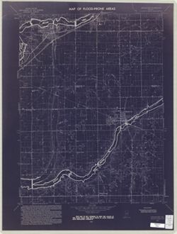
- Filing title: Middletown, Ind. Relief shown by contours and spot heights. Contour interval 10 feet. Includes quadrangle location map. Shows portion of Henry, Delaware, and Madison counties, including the regions of Chesterfield, Daleville, and Middletown, in Indiana. Scan of blueprint map. Flood prone areas and occasional flood information overprinted on U.S.G.S. 7.5 minute topographic quadrangle. "Base by U.S. Geological Survey, 1960." "The purpose of the flood-prone area maps is to show administrators, planners, and engineers concerned with future land developments those areas that are subject to flooding. The U.S. Geological Survey was requested by the 89th Congress to prepare these maps as expressed in House Document 465." "This map is not intended to show the limits of the flood plain over which state or local agencies have regulatory authority." For guide to all see Index to maps of flood-prone areas in Indiana prepared by William G. Weist. Indianapolis, Ind. : U.S. Geological Survey Water-resources investigations , 48-74, 1975. GB1399.I6 W4 (I 19.42/4:48-74)
- Call Number
- G4091.C32 s24 .G4 Middletown, Ind. 1970
- Caption
- Imprint: Washington, D.C. : Interior--Geological Survey, [1970]
- Filename
- VAC3073-M-00235
- Subject
- Topical Subject: Flood forecasting
- Topical Subject: Floodplains
- Geographic Subject: Delaware County (Ind.)
- Topical Subject: Floods
- Geographic Subject: Madison County (Ind.)
- Geographic Subject: Henry County (Ind.)
- Title
- Map of flood-prone areas, Middletown quadrangle, Indiana : 7.5 minute series (topographic)
- Producer
- United States. Federal Insurance Administration
- Geological Survey (U.S.)
- Physical Description
- Dimensions: 59 x 45 or smaller
- Scale: 1:24,000
- Item Identifiers
- Title Control Number: a18416331
- Alternate ID: CAW5372BB
- Persistent Identifier
- Campus
- IU Bloomington
- Date Created
- 1970
- Provenance
- Map of Flood-Prone Areas: Middletown Quadrangle, Indiana.
- Publisher
- Geological Survey (U.S.)
Relationships
关联
- 属于 Collection:
Items
Show Item Images
| 缩略图 | 标题 | 上传日期 | 公开度 | 行动 |
|---|---|---|---|---|
|
VAC3073-M-00235.jp2 | 2023-09-22 | 公开 |
|
|
VAC3073-00463.jp2 | 2023-09-22 | 公开 |
|