
Image
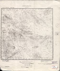
L-43-3 Public Deposited
- Original Publication Date
1937
- Genre
- Military Maps
- Topographic Maps
- Location
- Coordinates: 47.667, 73, 48, 73.5
- Related URL
- Abstract
- Modern area represented: Shet district, Kazakhstan
- Call Number
- G7000 s100 .S7 sheet L-43-3
- Caption
- Издание первое
- Copyright Owner
- No Copyright - United States
- Country
- СССР (USSR)
- Filename
- VAC9619-002535
- Subject
- Topical Subject: Maps
- Geographic Subject: Shet district
- Topical Subject: Soviet Union
- State/Region
- Казахская ССР (Kazakh Soviet Socialist Republic)
- Карагандинская область (Karaganda oblast)
- Четский район (Shet district)
- Title
- L-43-3
- Physical Description
- Scale: 1:100,000
- Language
- Russian
- Persistent Identifier
- Campus
- IU Bloomington
- Provenance
- DMA Topographic Center, Library of Congress G & M Division, Army Map Service Library
- Publisher
- Казахский Геологический Трест
Relationships
Relationships
- In Collection:
Items
Show Item Images
| Thumbnail | Title | Date Uploaded | Visibility | Actions |
|---|---|---|---|---|
|
VAC9619-002535.jp2 | 2024-01-18 | Public |
|
|
VAC9619-U-002252.jp2 | 2024-01-18 | Public |
|