
Image
Lumber, furniture, and other wood products industries, 1967 Public Deposited
- Genre
- Thematic maps
- Statistical maps
- Location
- Coordinates: W0880700 W0844500 N0414500 N0374600
- Related URL
- Abstract
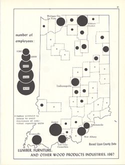
- Choropleth map with graduated circles showing the number of employees in each county employed by wood product industries in 1967. "Based upon county data." Detached from: An atlas of Indiana / by Robert C. Kingsbury , with contributions from John M. Hollingsworth and others. Bloomington, Indiana : Department of Geography, Indiana University, [1970]. Page 51.
- Call Number
- G4091.G8 1967 .K55
- Caption
- Imprint: [Bloomington, Indiana] : [Department of Geography, Indiana University], [1970]
- Filename
- VAC3073-M-00174
- Subject
- Geographic Subject: Indiana
- Topical Subject: Furniture industry and trade
- Topical Subject: Labor supply
- Topical Subject: Forest products industry
- Topical Subject: Statistics
- Title
- Lumber, furniture, and other wood products industries, 1967
- Producer
- Kingsbury, Robert C.
- Hollingsworth, John M.
- Physical Description
- Scale: Scale not given.
- Dimensions: 26 x 18 cm
- Item Identifiers
- Alternate ID: 317383IP
- Title Control Number: a18452119
- Persistent Identifier
- Campus
- IU Bloomington
- Date Created
- 1970
- Provenance
- An atlas of Indiana / by Robert C. Kingsbury [1970].
- Publisher
- Indiana University, Bloomington. Department of Geography
Relationships
Relationships
- In Collection:
Items
Show Item Images
| Thumbnail | Title | Date Uploaded | Visibility | Actions |
|---|---|---|---|---|
|
VAC3073-M-00174.jp2 | 2023-09-22 | Public |
|