
Image
Geologic map of Bean Blossom Valley, Monroe and Brown Counties, Indiana 公开 Deposited
- Genre
- Geological maps
- Location
- Coordinates: W0864107 W0860733 N0392122 N0391123
- Related URL
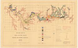
- Abstract
- Relief shown by spot heights. Includes index map. Shows sediments by glacial epoch as well as recent alluvium and colluvium deposits and Meramecian and Osagian bedrock. Also shows water reservoirs, Illinoian and Kansan glacial boundaries, edge of Upland areas, and other geological features. Base modified from Indiana Geological Survey Base Maps nos. 53 (Monroe County) and 7 (Brown County), Corrected to August, 1953. Glacial boundaries modified from Wayne, 1958b, Glacial Geology of Indiana. "Plate No. I."
- Call Number
- G4093.M7C5 1958 .P7
- Caption
- Imprint: [Bloomington, Indiana?] : [Alan Pratt], 1960.
- Filename
- VAC3073-M-01259
- Subject
- Geographic Subject: Monroe County (Ind.)
- Geographic Subject: Indiana
- Geographic Subject: Brown County (Ind.)
- Topical Subject: Glaciology
- Topical Subject: Geology
- Geographic Subject: Bean Blossom Valley (Ind. : Valley)
- Title
- Geologic map of Bean Blossom Valley, Monroe and Brown Counties, Indiana
- Producer
- Pratt, Alan (Geologist)
- Physical Description
- Dimensions: 32 x 77 cm, on sheet 52 x 82 cm
- Scale: 1:63,360
- Item Identifiers
- Title Control Number: a18455593
- Persistent Identifier
- Campus
- IU Bloomington
- Date Created
- 1960
- Provenance
- The geomorphology and geomorphic history of Bean Blossom Valley, Monroe and Brown Counties, Indiana / Alan R. Pratt. Thesis (A.M.)--Indiana University, 1960.
Relationships
关联
- 属于 Collection:
Items
Show Item Images
| 缩略图 | 标题 | 上传日期 | 公开度 | 行动 |
|---|---|---|---|---|
|
VAC3073-M-01259.jp2 | 2023-09-28 | 公开 |
|