
Image
Richland Township of Monroe County Public Deposited
- Genre
- Cadastral maps
- Location
- Coordinates: W0864102 W0863423 N0391509 N0390951
- Related URL
- Abstract
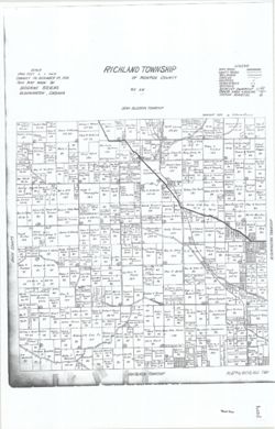
- Made by Katherine Stevens. Title in lower right corner: Plat #4, Richland Twp. Shows roads, creeks, railroads, churches, cemeteries, schools, and owner names with acreage. 9N 2W. Correct to December 29, 1938.
- Call Number
- G4093.M7G46 1939 .S74 Richland
- Caption
- Imprint: Bloomington, Indiana : Katherine Stevens, [1939]
- Filename
- VAC3073-M-01518
- Subject
- Geographic Subject: Richland (Monroe County, Ind. : Township)
- Topical Subject: Real property
- Topical Subject: Landowners
- Title
- Richland Township of Monroe County
- Producer
- Stevens, Katherine (Mapmaker)
- Physical Description
- Dimensions: on sheet 92 x 59 cm
- Scale: Approximately 1:18,000. 1,500 feet = 1 inch
- Item Identifiers
- Title Control Number: a18409340
- Persistent Identifier
- Campus
- IU Bloomington
- Date Created
- 1939
- Provenance
- Katherine Stevens. Township maps of Monroe County, Indiana, [1939]
- Publisher
- Stevens, Katherine (Mapmaker)
Relationships
Relationships
- In Collection:
Items
Show Item Images
| Thumbnail | Title | Date Uploaded | Visibility | Actions |
|---|---|---|---|---|
|
VAC3073-M-01518.jp2 | 2023-09-28 | Public |
|