
Image
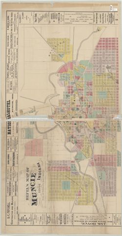
Hefel's map of Muncie Indiana Público Deposited
- Genre
- Maps
- Location
- Coordinates: W0852716 W0851914 N0401426 N0400856
- Related URL
- Abstract
- Includes advertisements from local businesses. Includes "Fire alarm boxes" locations.
- Call Number
- G4094 .M9 1891 .H44
- Caption
- Imprint: Philadelphia [Pa.] : E. P. Noll & Co., 1891.
- Filename
- VAC3073-M-00701
- Subject
- Geographic Subject: Muncie (Ind.)
- Title
- Hefel's map of Muncie Indiana
- Producer
- Hefel, Toney C.
- Physical Description
- Dimensions: 107 x 137 cm, on sheet 128 x 166 cm
- Scale: 1:4,800
- Item Identifiers
- Title Control Number: CAF2474BB
- Persistent Identifier
- Campus
- IU Bloomington
- Date Created
- 1891
- Publisher
- E.P. Noll & Co.
Relationships
Relaciones
- En Collection:
Items
Show Item Images
| Miniatura | Título | Fecha de subida | Visibilidad | Acciones |
|---|---|---|---|---|
|
VAC3073-M-00701.jp2 | 2023-10-17 | Público |
|
|
VAC3073-00490.jp2 | 2023-10-17 | Público |
|