
Image
Hoosier National Forest Public Deposited
- Genre
- Tourist maps
- Location
- Coordinates: W0865130 W0861800 N0385800 N0375000
- Related URL
- Abstract
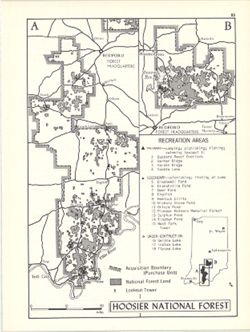
- Shows primary and secondary recreation areas, recreation areas under construction, lookout towers, acquisition boundary (purchase unit), and Hoosier National Forest land. Includes index of recreation areas. Includes ancillary map of the northern portion of Hoosier State Forest and location map. Detached from: An atlas of Indiana / by Robert C. Kingsbury , with contributions from John M. Hollingsworth and others. Bloomington, Indiana : Department of Geography, Indiana University, [1970]. Page 85.
- Call Number
- G1400 .K53 1970
- Caption
- Imprint: Bloomington, Indiana : Department of Geography, Indiana University, [1970]
- Filename
- VAC3073-M-00211
- Subject
- Topical Subject: Public lands
- Geographic Subject: Hoosier National Forest (Ind.)
- Topical Subject: Forest reserves
- Topical Subject: Outdoor recreation
- Title
- Hoosier National Forest
- Producer
- Hollingsworth, John M.
- Kingsbury, Robert C.
- Physical Description
- Scale: Approximately 1:550,000
- Dimensions: 26 x 18 cm, on sheet 28 x 21 cm
- Item Identifiers
- Alternate ID: 317383IP
- Title Control Number: a15938174
- Persistent Identifier
- Campus
- IU Bloomington
- Date Created
- 1970
- Provenance
- An atlas of Indiana / by Robert C. Kingsbury [1970].
- Publisher
- Indiana University. Department of Geography
Relationships
Relationships
- In Collection:
Items
Show Item Images
| Thumbnail | Title | Date Uploaded | Visibility | Actions |
|---|---|---|---|---|
|
VAC3073-M-00211.jp2 | 2023-09-22 | Public |
|