
Image
Bedford and vicinity Public Deposited
- Genre
- Road maps
- Thematic maps
- Location
- Coordinates: W0863134 W0862736 N0385324 N0385042
- Related URL
- Abstract
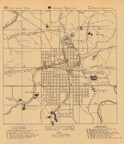
- "The 15 etching maps of the individual quarries or quarry districts, have been written and prepared by Raymond S. Blatchley from data gathered by him personally during the summer months of 1907"--32nd Annual report, page 302. Shows locations of stone companies in Bedford, Indiana. Detached from: The Indiana oolitic limestone industry in 1907 / Raymond S. Blatchley. In Indiana Department of Geology and Natural Resources thirty-second annual report ... 1907. Indianapolis : Wm. B. Burford, 1908. Page 438.
- Call Number
- G4094.B3M2 1907 .B53
- Caption
- Imprint: [Indianapolis] : [Indiana Department of Geology and Natural Resources], [1908]
- Filename
- VAC3073-M-00628
- Subject
- Geographic Subject: Lawrence County (Ind.)
- Topical Subject: Stone-cutting
- Topical Subject: Limestone industry
- Geographic Subject: Bedford (Ind.)
- Topical Subject: IGS Annual Reports
- Title
- Bedford and vicinity
- Producer
- Blatchley, Raymond S. (Raymond Sillliman)
- Physical Description
- Dimensions: 23 x 20 cm
- Scale: Scale not given.
- Item Identifiers
- Alternate ID: 390726IP
- Title Control Number: a18299189
- Persistent Identifier
- Campus
- IU Bloomington
- Date Created
- 1908
- Provenance
- 32nd Annual Report (1907) / Indiana. Department of Geology and Natural Resources.
- Publisher
- Indiana. Department of Geology and Natural Resources
Relationships
Relationships
- In Collection:
Items
Show Item Images
| Thumbnail | Title | Date Uploaded | Visibility | Actions |
|---|---|---|---|---|
|
VAC3073-00016.jp2 | 2023-09-25 | Public |
|