
Search Constraints
« Previous |
1 - 10 of 30
|
Next »
Search Results
-
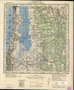
- Description:
- 1899
- Subject:
- Topical Subject: Maps, Topical Subject: Soviet Union, and Geographic Subject: Bernāti
- Publisher:
- Генеральный штаб РККА
- Language:
- Russian
- Date Created:
- 1907
- Identifier:
- VAC9619-001736
- Genre:
- Topographic Maps and Military Maps
- Geographic Location:
- Coordinates: 56.333, 20.967, 56.5, 21.25
- Related URL:
- DataCORE Dataset Download: https://datacore.iu.edu/concern/data_sets/2v23vv147
- Abstract:
- Modern area represented: Bernāti, Latvia
- Call Number:
- G7000 s50 .S68 sheet O-34-126-D
- City:
- Бернати (Bernāti)
- Copyright Holder:
- No Copyright - United States
- Country:
- Латвия (Latvia)
- Physical Description:
- Scale: 1:50,000
- Persistent URL:
- http://purl.dlib.indiana.edu/iudl/images/VAC9619/VAC9619-001736
- Provenance:
- CIA Map Branch -- Received
-
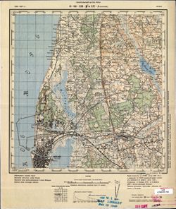
- Description:
- 1905
- Subject:
- Geographic Subject: Liepāja, Topical Subject: Maps, and Topical Subject: Soviet Union
- Publisher:
- Генеральный штаб РККА
- Language:
- Russian
- Date Created:
- 1907
- Identifier:
- VAC9619-001735
- Genre:
- Military Maps and Topographic Maps
- Geographic Location:
- Coordinates: 56.5, 20.959, 56.667, 21.25
- Related URL:
- DataCORE Dataset Download: https://datacore.iu.edu/concern/data_sets/bz60cx036
- Abstract:
- Modern area represented: Liepāja, Latvia
- Call Number:
- G7000 s50 .S68 sheet O-34-126-B
- City:
- Лиэпайя (Liepāja)
- Copyright Holder:
- No Copyright - United States
- Country:
- Латвия (Latvia)
- Physical Description:
- Scale: 1:50,000
- Persistent URL:
- http://purl.dlib.indiana.edu/iudl/images/VAC9619/VAC9619-001735
- Provenance:
- M. I. Map Library, GS, RA
-
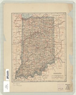
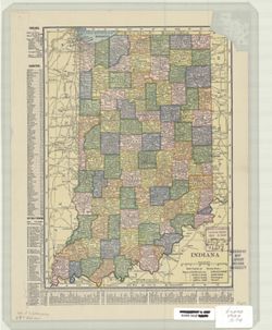
- Subject:
- Geographic Subject: Indiana
- Creator:
- L.L. Poates Engr'g Co.
- Publisher:
- Dodd, Mead & Company
- Date Created:
- 1907
- Identifier:
- VAC3073-M-00956
- Genre:
- Maps
- Geographic Location:
- Coordinates: W0880700 W0840000 N0414500 N0375200
- Related URL:
- Catalog URL: https://iucat.iu.edu/catalog/5163998
- Abstract:
- Relief shown by hachures. Shows counties, county seats, railroads, and canals.
- Call Number:
- G4090 1907 .L57
- Caption:
- Imprint: [New York] : Dodd, Mead & Co., [1907]
- Physical Description:
- Dimensions: 26 x 21 cm and Scale: 1:1,750,000
- Alternate Identifier:
- Title Control Number: a5163998
- Persistent URL:
- https://purl.dlib.indiana.edu/iudl/images/VAC3073/VAC3073-M-00956
-
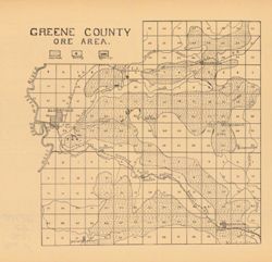
- Subject:
- Geographic Subject: Greene County (Ind.), Topical Subject: Iron ores, and Topical Subject: IGS Annual Reports
- Publisher:
- Indiana. Department of Geology and Natural Resources
- Date Created:
- 1907
- Identifier:
- VAC3073-M-00949
- Genre:
- Geological maps
- Geographic Location:
- Coordinates: W0871431 W0864053 N0391018 N0385418
- Related URL:
- Catalog URL: https://iucat.iu.edu/catalog/18299136
- Abstract:
- Detached from: The iron ore deposits of Indiana / Charles W. Shannon. In Indiana Dept. of Geology and Natural Resources thirty-first annual report, 1906. Ind...
- Call Number:
- G4093.G7H2 1907 .G7
- Caption:
- Imprint: [Indianapolis] : [Indiana Dept. of Geology and Natural Resources], [1907] and Imprint: [Indianapolis] : [Wm. B. Burford], [1907]
- Physical Description:
- Dimensions: on sheet 23 x 24 cm and Scale: Approximately 1:130,000
- Alternate Identifier:
- Alternate ID: 390726IP and Title Control Number: a18299136
- Persistent URL:
- https://purl.dlib.indiana.edu/iudl/images/VAC3073/VAC3073-M-00949
- Provenance:
- 31st Annual Report (1906) / Indiana. Department of Geology and Natural Resources.
-
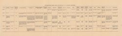
- Subject:
- Geographic Subject: Indiana and Topical Subject: IGS Annual Reports
- Publisher:
- Indiana. Department of Geology and Natural Resources
- Date Created:
- 1907
- Identifier:
- VAC3073-M-00929
- Genre:
- Charts
- Related URL:
- Catalog URL: https://iucat.iu.edu/catalog/4022271
- Abstract:
- From page 290 of 31st Annual Report.
- Call Number:
- QE109 .A2 1906
- Caption:
- Imprint: Indianapolis : 1907
- Physical Description:
- Dimensions: 19 x 63 cm
- Alternate Identifier:
- Title Control Number: 390726IP
- Persistent URL:
- https://purl.dlib.indiana.edu/iudl/images/VAC3073/VAC3073-M-00929
- Provenance:
- 31st Annual Report (1906) / Indiana. Department of Geology and Natural Resources.
-
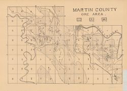
- Subject:
- Geographic Subject: Martin County (Ind.), Topical Subject: IGS Annual Reports, and Topical Subject: Iron ores
- Publisher:
- Indiana. Department of Geology and Natural Resources
- Date Created:
- 1907
- Identifier:
- VAC3073-M-00898
- Genre:
- Geological maps
- Geographic Location:
- Coordinates: W0865526 W0864056 N0385428 N0382940
- Related URL:
- Catalog URL: https://iucat.iu.edu/catalog/18299172
- Abstract:
- Detached from: The iron ore deposits of Indiana / Charles W. Shannon. In Indiana Dept. of Geology and Natural Resources thirty-first annual report, 1906. Ind...
- Call Number:
- G4093.M5H2 1907 .M3
- Caption:
- Imprint: [Indianapolis] : [Indiana Dept. of Geology and Natural Resources], [1907] and Imprint: [Indianapolis] : [Wm. B. Burford], [1907]
- Physical Description:
- Scale: Approximately 1:59,000 and Dimensions: on sheet 27 x 37 cm
- Alternate Identifier:
- Alternate ID: 390726IP and Title Control Number: a18299172
- Persistent URL:
- https://purl.dlib.indiana.edu/iudl/images/VAC3073/VAC3073-M-00898
- Provenance:
- 31st Annual Report (1906) / Indiana. Department of Geology and Natural Resources.
-
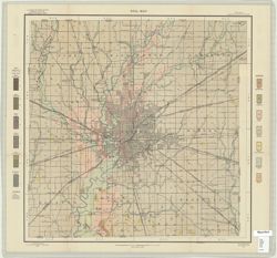
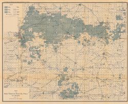
- Subject:
- Topical Subject: Soils, Topical Subject: Classification, and Geographic Subject: Marion County (Ind.)
- Publisher:
- United States. Bureau of Soils
- Date Created:
- 1907
- Identifier:
- VAC3073-M-00876
- Genre:
- Thematic maps
- Geographic Location:
- Coordinates: W0862000 W0855700 N0395600 N0393800
- Related URL:
- Catalog URL: https://iucat.iu.edu/catalog/2872554
- Abstract:
- Soils surveyed by W. J. Geib and Frank C. Schroeder. Shows soil types classification by colors and symbols.
- Call Number:
- G4093 .M3J3 1907 .G45
- Caption:
- Imprint: Washington, D.C.: Bureau of Soils. [1907?]
- Physical Description:
- Dimensions: 51 x 50 cm and Scale: 1:63,360
- Alternate Identifier:
- Title Control Number: CAY7156BB
- Persistent URL:
- https://purl.dlib.indiana.edu/iudl/images/VAC3073/VAC3073-M-00876
- Provenance:
- Soil Map, Indiana, Marion County Sheet.
-
- Subject:
- Geographic Subject: Indiana
- Creator:
- C.S. Hammond & Company
- Publisher:
- C.S. Hammond & Company
- Date Created:
- 1907
- Identifier:
- VAC3073-M-00851
- Genre:
- Maps
- Geographic Location:
- Coordinates: W0880700 W0844500 N0414500 N0375200
- Related URL:
- Catalog URL: https://iucat.iu.edu/catalog/5166890
- Abstract:
- Shows counties, cities and towns by population, and railroads. Includes area and populations statistics and indexes to counties and cities and towns.
- Call Number:
- G4090 1907 .C74
- Caption:
- Imprint: New York : Hammond, [1907]
- Physical Description:
- Dimensions: 27 x 20 cm and Scale: 1:1,600,000
- Alternate Identifier:
- Title Control Number: a5166890
- Persistent URL:
- https://purl.dlib.indiana.edu/iudl/images/VAC3073/VAC3073-M-00851
-
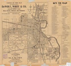
- Subject:
- Geographic Subject: Marion (Ind.), Topical Subject: Real property, and Topical Subject: Landowners
- Creator:
- White, Frank W., C.E.
- Publisher:
- DeWolf, White & Co.
- Date Created:
- 1907
- Identifier:
- VAC3073-M-00831
- Genre:
- Cadastral maps
- Geographic Location:
- Coordinates: W0854353 W0853222 N0403527 N0402844
- Related URL:
- Catalog URL: https://iucat.iu.edu/catalog/6083219
- Abstract:
- Partial cadastral map showing landowners. Shows radial distances. Includes indexes.
- Call Number:
- G4094.M3 G46 1907 .W45
- Caption:
- Imprint: Marion, Ind. : DeWolf, White & Co., [1907]
- Physical Description:
- Scale: Scale not given. and Dimensions: 41 x 39 cm, on sheet 43 x 46 cm
- Alternate Identifier:
- Title Control Number: a6083219
- Persistent URL:
- https://purl.dlib.indiana.edu/iudl/images/VAC3073/VAC3073-M-00831
-
- Subject:
- Topical Subject: Oil fields and Geographic Subject: Indiana
- Creator:
- Blatchley, W. S. (Willis Stanley), 1859-1940
- Publisher:
- Indiana. Department of Geology and Natural Resources
- Date Created:
- 1907
- Identifier:
- VAC3073-M-00778
- Genre:
- Geological maps
- Geographic Location:
- Coordinates: W0854720 W0844820 N0404500 N0400900
- Related URL:
- Catalog URL: https://iucat.iu.edu/catalog/16077853
- Abstract:
- In 31st Annual report of the Department of Geology and Natural Resources of Indiana, 1906. "January 1, 1907." Shows good, fair, and light oil terri...
- Call Number:
- G4091.H8 1906 .B5
- Caption:
- Imprint: Indianapolis, Ind. : Wm. B. Burford, [1907]
- Physical Description:
- Scale: Approximately 1:126,720. 2 miles = 1 inch and Dimensions: 53 x 67 cm
- Alternate Identifier:
- Alternate ID: 390726IP and Title Control Number: a16077853
- Persistent URL:
- https://purl.dlib.indiana.edu/iudl/images/VAC3073/VAC3073-M-00778
- Provenance:
- 31st Annual Report (1906) / Indiana. Department of Geology and Natural Resources.

- « Previous
- Next »
- 1
- 2
- 3