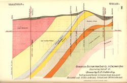
Geological cross section showing stratigraphy of mineral resources, including various coal, limestone, and shale layers. Relative relief in relation to sea l...
Call Number:
QE109 .A2
Caption:
Imprint: [Indianapolis] : [Indiana, Dept. of Geology and Natural Resources], [1894] and Imprint: Indpls : lithographed by William B. Burford, [1894]
Physical Description:
Scale: Approximately 1:1,900,800. 30 miles to the inch. Vertical scale approximately 1:6,000. 500 feet to the inch and Dimensions: 15 x 23 cm
Alternate Identifier:
Title Control Number: a18188969 and Alternate ID: 390726IP
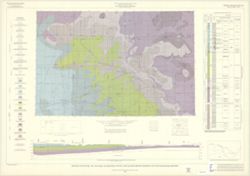
By Allan F. Schneider and Stanley J. Keller. Transverse Mercator projection. "Indiana Geological Survey in cooperation with Illinois State Geological Su...
Gray, Henry Hamilton, 1922-, Wier, Charles E. (Charles Eugene), 1921-, Indiana. Geological Survey, Wayne, William J. (William John), 1922-, and Illinois Stat...
Publisher:
Indiana. Geological Survey
Date Created:
1970
Identifier:
VAC3073-M-01257
Genre:
Quadrangle maps, Geological maps, and Geological cross-sections
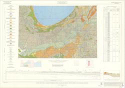
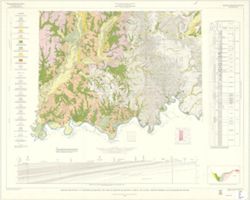
By Henry H. Gray, William J. Wayne, and Charles E. Wier , Indiana Geological Survey, in cooperation with Illinois State Geological Survey. Transverse Mercato...
By Henry H. Gray, William J. Wayne, and Charles E. Wier , Indiana Geological Survey, in cooperation with Illinois State Geological Survey. Transverse Mercato...
Call Number:
G4091.C5 s250 .I5 Vincennes
Caption:
Imprint: [Bloomington, Ind.] : The Survey, 1970
Physical Description:
Dimensions: 76 x 102 cm and Scale: 1:250,000. Vertical scale approximately 1:11,500
Indiana. Geological Survey, Bleuer, N. K. (Ned Kermit), 1943-, Lineback, Jerry A. (Jerry Alvin), Hill, John R,, Gray, Henry Hamilton, 1922-, and Illinois Sta...
Publisher:
Indiana. Geological Survey
Date Created:
1979
Identifier:
VAC3073-M-01251
Genre:
Quadrangle maps, Geological maps, and Geological cross-sections
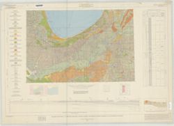
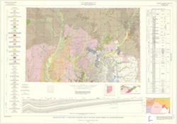
Indianapolis sheet. 1979 edition. Transverse Mercator projection. Geology compiled by H. H. Gray (Indiana) and J. A. Lineback (Illinois) from published and o...
By Charles E. Wier and Henry H. Gray. Geology by H.H. Gray [and others]. Drafted by R. E. Judah and W. H. Moran. Base modified from Army Map Service map NJ 1...
Keller, Stanley J., Indiana. Geological Survey, Illinois State Geological Survey, Johnson, Gerald H., Wayne, William J. (William John), 1922-, and Atherton, ...
Publisher:
Indiana. Geological Survey
Date Created:
1962
Identifier:
VAC3073-M-01248
Genre:
Geological maps, Quadrangle maps, and Geological cross-sections
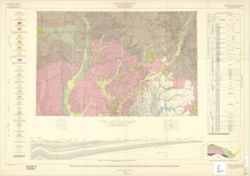
By William J. Wayne, Gerald H. Johnson, and Stanley J. Keller. Indiana Geological Survey in cooperation with Illinois State Geological Survey. Base modified ...
By Prof. E. T. Cox, Prof Leo Lesquereux. Title derived from caption titles. Includes 3 sections showing coal measures. No. 3. Connected section of coal measu...
Call Number:
G4091.H9 1870 .C69
Caption:
Imprint: [Indianapolis] : [Geological Survey of Indiana], [1871]
Physical Description:
Dimensions: 21 x 23 cm and Scale: Scale not given.
Alternate Identifier:
Title Control Number: a18308391 and Alternate ID: 390721IP
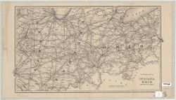
Prime meridians: Greenwich, Washington."Entered according to Act of Congress in the year 1875 by G. W. and C. B. Colton & Co in the Office of the Li...
Call Number:
G4901.P3 1875 .G8
Caption:
Imprint: [New York] : G. W. and C. B. Colton and Co., 1875.


![[Coal measure sections in Indiana, Southern Illinois, and Western Kentucky]](https://iiif.uits.iu.edu/iiif/2/bz60f023f%2Ffiles%2F64b4d7e0-2da2-4574-93ae-d19cd0523815/full/250,/0/default.jpg)