
Search Constraints
You searched for:
Date Created
1931
Remove constraint Date Created: 1931
Holding Location
B-WELLS
Remove constraint Holding Location: B-WELLS
State/Province
РСФСР (RSFSR)
Remove constraint State/Province: РСФСР (RSFSR)
« Previous |
1 - 10 of 13
|
Next »
Search Results
-
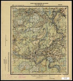
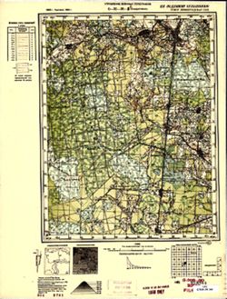
- Description:
- 1929
- Subject:
- Geographic Subject: Kholm, Topical Subject: Soviet Union, and Topical Subject: Maps
- Publisher:
- Военно-топографическое управление
- Language:
- Russian
- Date Created:
- 1931
- Identifier:
- VAC9619-003546
- Genre:
- Topographic Maps and Military Maps
- Geographic Location:
- Coordinates: 57, 31, 57.167, 31.25
- Related URL:
- DataCORE Dataset Download: https://datacore.iu.edu/concern/data_sets/8p58pd72f
- Abstract:
- Modern area represented: Холм (Kholm), Novgorodskaya oblast, Russia
- Call Number:
- GM G7000 s50 .S68 sheet O-36-99-C
- Caption:
- Не подлежит оглашению and Captured map
- City:
- Холм (Kholm)
- Copyright Holder:
- No Copyright - United States
- Country:
- СССР (USSR)
- State/Province:
- Западная область (Western oblast) and РСФСР (RSFSR)
- Physical Description:
- Scale: 1:50,000
- Persistent URL:
- http://purl.dlib.indiana.edu/iudl/images/VAC9619/VAC9619-003546
- Provenance:
- DMA Topographic Center, Army Map Service Library, Library of Congress Geography & Map Division
-
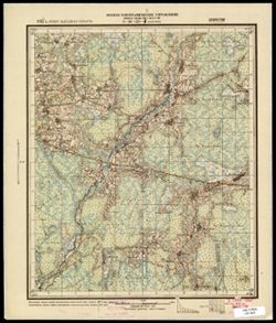
- Description:
- 1929
- Subject:
- Topical Subject: Maps, Geographic Subject: Grukhovka, and Topical Subject: Soviet Union
- Publisher:
- Военно-топографическое управление
- Language:
- Russian
- Date Created:
- 1931
- Identifier:
- VAC9619-003543
- Genre:
- Military Maps and Topographic Maps
- Geographic Location:
- Coordinates: 57, 30.75, 57.167, 31
- Related URL:
- DataCORE Dataset Download: https://datacore.iu.edu/concern/data_sets/hh63sw71w
- Abstract:
- Modern area represented: Груховка (Grukhovka), Novgorodskaya oblast, Russia
- Call Number:
- GM G7000 s50 .S68 sheet O-36-98-D
- Caption:
- Captured map and Не подлежит оглашению
- City:
- Груховка (Grukhovka)
- Copyright Holder:
- No Copyright - United States
- Country:
- СССР (USSR)
- State/Province:
- РСФСР (RSFSR) and Западная область (Western oblast)
- Physical Description:
- Scale: 1:50,000
- Persistent URL:
- http://purl.dlib.indiana.edu/iudl/images/VAC9619/VAC9619-003543
- Provenance:
- Army Map Service Library, OMAHA, Library of Congress Geography & Map Division
-
- Description:
- 1927
- Subject:
- Topical Subject: Soviet Union, Topical Subject: Maps, and Geographic Subject: Rudnya
- Publisher:
- Военно-топографическое управление
- Language:
- Russian
- Date Created:
- 1931
- Identifier:
- VAC9619-003497
- Genre:
- Military Maps and Topographic Maps
- Geographic Location:
- Coordinates: 56.0, 32.0, 56.16667, 32.25
- Related URL:
- DataCORE Dataset Download: https://datacore.iu.edu/concern/data_sets/pc289j90s
- Abstract:
- Modern area represented: Рудня (Rudnya), Tverskaya oblast, Russia
- Call Number:
- G7000 s50 .S68 sheet O-36-137-C
- Caption:
- Секретно
- City:
- Рудня (Rudnya)
- Copyright Holder:
- No Copyright - United States
- Country:
- СССР (USSR)
- State/Province:
- Западная область (Western oblast) and РСФСР (RSFSR)
- Physical Description:
- Scale: 1:50,000
- Persistent URL:
- http://purl.dlib.indiana.edu/iudl/images/VAC9619/VAC9619-003497
- Provenance:
- CIA Map Branch -- Received
-
- Description:
- 1927
- Subject:
- Topical Subject: Maps, Geographic Subject: Kostino, and Topical Subject: Soviet Union
- Publisher:
- Военно-топографическое управление
- Language:
- Russian
- Date Created:
- 1931
- Identifier:
- VAC9619-003496
- Genre:
- Military Maps and Topographic Maps
- Geographic Location:
- Coordinates: 56.16667, 32.25, 56.3333, 32.5
- Related URL:
- DataCORE Dataset Download: https://datacore.iu.edu/concern/data_sets/zg64tm67b
- Abstract:
- Modern area represented: Костино (Kostino), Tverskaya oblast, Russia
- Call Number:
- G7000 s50 .S68 sheet O-36-137-B
- Caption:
- Секретно
- City:
- Костино (Kostino)
- Copyright Holder:
- No Copyright - United States
- Country:
- СССР (USSR)
- State/Province:
- Западная область (Western oblast) and РСФСР (RSFSR)
- Physical Description:
- Scale: 1:50,000
- Persistent URL:
- http://purl.dlib.indiana.edu/iudl/images/VAC9619/VAC9619-003496
- Provenance:
- CIA Map Branch -- Received
-
- Description:
- 1927
- Subject:
- Geographic Subject: Sutrimino, Topical Subject: Maps, and Topical Subject: Soviet Union
- Publisher:
- Военно-топографическое управление
- Language:
- Russian
- Date Created:
- 1931
- Identifier:
- VAC9619-003493
- Genre:
- Military Maps and Topographic Maps
- Geographic Location:
- Coordinates: 56, 31.5, 56.167, 31.75
- Related URL:
- DataCORE Dataset Download: https://datacore.iu.edu/concern/data_sets/xp68kh09j
- Abstract:
- Modern area represented: Сутрмино (Sutrimino), Tverskaya oblast, Russia
- Call Number:
- G7000 s50 .S68 sheet O-36-136-C
- Caption:
- Captured map and Секретно
- City:
- Сутрмино (Sutrimino)
- Copyright Holder:
- No Copyright - United States
- Country:
- СССР (USSR)
- State/Province:
- РСФСР (RSFSR) and Западная область (Western oblast)
- Physical Description:
- Scale: 1:50,000
- Persistent URL:
- http://purl.dlib.indiana.edu/iudl/images/VAC9619/VAC9619-003493
- Provenance:
- Army Map Service Library, OMAHA, Library of Congress Geography & Map Division
-

- Subject:
- Topical Subject: Soviet Union, Geographic Subject: Trushkovo, and Topical Subject: Maps
- Publisher:
- Управление военных топографов
- Language:
- Russian
- Date Created:
- 1931
- Identifier:
- VAC9619-003483
- Genre:
- Military Maps and Topographic Maps
- Geographic Location:
- Coordinates: 56, 30, 56.167, 30.25
- Related URL:
- DataCORE Dataset Download: https://datacore.iu.edu/concern/data_sets/mk61rh73z
- Abstract:
- Modern area represented: Трушково (Trushkovo), Pskovskaya oblast, Russia
- Call Number:
- G7000 s50 .S68 sheet O-36-133-C
- Caption:
- Не подлежит оглашению
- City:
- Трушкова (Trushkova)
- Copyright Holder:
- No Copyright - United States
- Country:
- СССР (USSR)
- State/Province:
- Западная область (Western oblast) and РСФСР (RSFSR)
- Physical Description:
- Scale: 1:50,000
- Persistent URL:
- http://purl.dlib.indiana.edu/iudl/images/VAC9619/VAC9619-003483
- Provenance:
- M. I. Map Library
-
- Description:
- 1925
- Subject:
- Topical Subject: Soviet Union, Topical Subject: Maps, and Geographic Subject: Vysotsko
- Publisher:
- Управление военных топографов РККА
- Language:
- Russian
- Date Created:
- 1931
- Identifier:
- VAC9619-002808
- Genre:
- Military Maps and Topographic Maps
- Geographic Location:
- Coordinates: 57.667, 28.75, 57.833, 29
- Related URL:
- DataCORE Dataset Download: https://datacore.iu.edu/concern/data_sets/0p0967819
- Abstract:
- Modern area represented: Высоцко (Vysotsko), Псковская область (Pskovskaya oblast), Russia
- Call Number:
- GM G7000 s50 .S68 sheet O-35-82-D
- Caption:
- Не подлежит оглашению
- City:
- Высоцкая (Vysotsko)
- Copyright Holder:
- No Copyright - United States
- Country:
- СССР (USSR)
- State/Province:
- Ленинградская область (Leningrad oblast) and РСФСР (RSFSR)
- Physical Description:
- Scale: 1:50,000
- Persistent URL:
- http://purl.dlib.indiana.edu/iudl/images/VAC9619/VAC9619-002808
- Provenance:
- M. I. Map Library, Reichsamt für Landesaufnahme, Kartensammlung
-
- Description:
- 1892
- Subject:
- Topical Subject: Maps, Topical Subject: Soviet Union, and Geographic Subject: Rozhdestveno
- Publisher:
- Управление военных топографов
- Language:
- Russian
- Date Created:
- 1931
- Identifier:
- VAC9619-001848
- Genre:
- Topographic Maps and Military Maps
- Geographic Location:
- Coordinates: 59.167, 29.75, 59.333, 30
- Related URL:
- DataCORE Dataset Download: https://datacore.iu.edu/concern/data_sets/hq37vp337
- Abstract:
- Modern area represented: Rozhdestveno, Russia
- Call Number:
- G7000 s50 .S68 sheet O-35-36-B
- Caption:
- Не подлежит оглашению
- City:
- Рождествено (Rozhdestveno)
- Copyright Holder:
- No Copyright - United States
- Country:
- СССР (USSR)
- State/Province:
- Ленинградская область (Leningrad oblast) and РСФСР (RSFSR)
- Physical Description:
- Scale: 1:50,000
- Persistent URL:
- http://purl.dlib.indiana.edu/iudl/images/VAC9619/VAC9619-001848
- Provenance:
- G000-30, CIA Map Branch -- Received
-
- Description:
- 1892
- Subject:
- Topical Subject: Soviet Union, Topical Subject: Maps, and Geographic Subject: Nikolskoye
- Publisher:
- Управление военных топографов
- Language:
- Russian
- Date Created:
- 1931
- Identifier:
- VAC9619-001817
- Genre:
- Military Maps and Topographic Maps
- Geographic Location:
- Coordinates: 59.333, 29.75, 59.5, 30
- Related URL:
- DataCORE Dataset Download: https://datacore.iu.edu/concern/data_sets/x059c830z
- Abstract:
- Modern area represented: Nikolskoye, Leningrad oblast, Russia
- Call Number:
- G7000 s50 .S68 sheet O-35-24-Г
- Caption:
- Не подлежит оглашению
- City:
- Сиворицы (Sivoritsy)
- Copyright Holder:
- No Copyright - United States
- Country:
- СССР (USSR)
- State/Province:
- Ленинградская область (Leningrad oblast) and РСФСР (RSFSR)
- Physical Description:
- Scale: 1:50,000
- Persistent URL:
- http://purl.dlib.indiana.edu/iudl/images/VAC9619/VAC9619-001817
- Provenance:
- Army Map Service Library, Library of Congress Geography & Map Division, OMAHA
-
- Description:
- 1888
- Subject:
- Geographic Subject: Voyskovitsy, Topical Subject: Maps, and Topical Subject: Soviet Union
- Publisher:
- Управление военных топографов
- Language:
- Russian
- Date Created:
- 1931
- Identifier:
- VAC9619-001815
- Genre:
- Topographic Maps and Military Maps
- Geographic Location:
- Coordinates: 59.5, 29.75, 59.667, 30
- Related URL:
- DataCORE Dataset Download: https://datacore.iu.edu/concern/data_sets/2801ph077
- Abstract:
- Modern area represented: Voyskovitsy, Leningrad oblast, Russia
- Call Number:
- G7000 s50 .S68 sheet O-35-24-B
- Caption:
- Не подлежит оглашению
- City:
- Ст. Войсковицы (Voyskovitsy)
- Copyright Holder:
- No Copyright - United States
- Country:
- СССР (USSR)
- State/Province:
- РСФСР (RSFSR) and Ленинградская область (Leningrad oblast)
- Physical Description:
- Scale: 1:50,000
- Persistent URL:
- http://purl.dlib.indiana.edu/iudl/images/VAC9619/VAC9619-001815
- Provenance:
- DMA Topographic Center, Army Map Service Library, OMAHA, Library of Congress Geography & Map Division
