
Search Constraints
You searched for:
Publisher
Главное Управление Геодезии и Картографии при СНК СССР
Remove constraint Publisher: Главное Управление Геодезии и Картографии при СНК СССР
« Previous |
1 - 50 of 127
|
Next »
Search Results
-
- Description:
- 1939
- Subject:
- Geographic Subject: Lushchikovo, Topical Subject: Soviet Union, and Topical Subject: Maps
- Publisher:
- Главное Управление Геодезии и Картографии при СНК СССР
- Language:
- Russian
- Date Created:
- 1941
- Identifier:
- VAC9619-001316
- Genre:
- Topographic Maps and Military Maps
- Geographic Location:
- Coordinates: 54.667, 33.5, 54.833, 33.75
- Related URL:
- Download GeoTIFF: https://drive.google.com/open?id=1QqwkbeqMxBP_h4g_YQjctsz1Sdi9nkJC and Catalog URL: http://iucat.iu.edu/catalog/5020131
- Abstract:
- Modern area represented: Lushchikovo, Smolensk oblast, Russia
- Call Number:
- GM G7000 S50 .S68 N-36-44-C
- Copyright Holder:
- No Copyright - United States
- Country:
- СССР (USSR)
- State/Province:
- РСФСР (RSFSR) and Смоленская область (Smolensk oblast)
- Physical Description:
- Scale: 1:50,000
- Persistent URL:
- http://purl.dlib.indiana.edu/iudl/images/VAC9619/VAC9619-001316
- Provenance:
- M. I. Map Library, G000-30, CIA Map Library
-
- Description:
- 1938
- Subject:
- Topical Subject: Maps, Geographic Subject: Vasilyevo, and Topical Subject: Soviet Union
- Publisher:
- Главное Управление Геодезии и Картографии при СНК СССР
- Language:
- Russian
- Date Created:
- 1941
- Identifier:
- VAC9619-001873
- Genre:
- Military Maps and Topographic Maps
- Geographic Location:
- Coordinates: 55.1667, 36, 55.3333, 36.25
- Related URL:
- Download GeoTIFF: https://drive.google.com/open?id=1K6w6CW9dTrPwudpPrBYVpbWjdNeeC133 and Catalog URL: http://iucat.iu.edu/catalog/5020131
- Abstract:
- Modern area represented: Vasilyevo, Russia
- Call Number:
- G7000 s50 .S68 sheet N-37-25-A
- City:
- Васильево (Vasilyevo)
- Copyright Holder:
- No Copyright - United States
- Country:
- СССР (USSR)
- State/Province:
- Московская область (Moscow oblast), РСФСР (RSFSR), and Смоленская область (Smolensk oblast)
- Physical Description:
- Scale: 1:50,000
- Persistent URL:
- http://purl.dlib.indiana.edu/iudl/images/VAC9619/VAC9619-001873
- Provenance:
- DMA Topographic Center, Army Map Service Library, OMAHA, Library of Congress Geography & Map Division
-

- Description:
- 1938
- Subject:
- Geographic Subject: Novhorod-Siverskyy, Topical Subject: Maps, and Topical Subject: Soviet Union
- Publisher:
- Главное Управление Геодезии и Картографии при СНК СССР
- Language:
- Russian
- Date Created:
- 1941
- Identifier:
- VAC9619-004216
- Genre:
- Military Maps and Topographic Maps
- Geographic Location:
- Coordinates: 52, 33, 52.333, 33.5
- Related URL:
- Download GeoTIFF: https://drive.google.com/file/d/1kaJZgYyUS6Hj_BGfB5UeL-vO4ElM_lO7/view?usp=sharing and Catalog URL: https://iucat.iu.edu/catalog/5020129
- Abstract:
- Modern area represented: Novhorod-Siverskyy, Chernihiv oblast, Ukraine
- Call Number:
- G7000 s100 .S7 sheet N-36-139
- Caption:
- Для служебного пользования
- City:
- Новгород-Северский (Novhorod-Siverskyy)
- Copyright Holder:
- No Copyright - United States
- Country:
- СССР (USSR)
- State/Province:
- Черниговская область (Chernihiv oblast), Украинская ССР (Ukrainian Soviet Socialist Republic), Сумская область (Sumy oblast), РСФСР (RSFSR), and Орловская об...
- Physical Description:
- Scale: 1:100,000
- Persistent URL:
- http://purl.dlib.indiana.edu/iudl/images/VAC9619/VAC9619-004216
- Provenance:
- DMA Topographic Center, Army Map Service Library, OMAHA, Library of Congress Geography & Map Division
-
- Description:
- 1938
- Subject:
- Topical Subject: Maps, Topical Subject: Soviet Union, and Geographic Subject: Rydelovo
- Publisher:
- Главное Управление Геодезии и Картографии при СНК СССР
- Language:
- Russian
- Date Created:
- 1941
- Identifier:
- VAC9619-001205
- Genre:
- Military Maps and Topographic Maps
- Geographic Location:
- Coordinates: 55.8333, 33.25, 56, 33.5
- Related URL:
- Download GeoTIFF: https://drive.google.com/open?id=1QB4vYv8ua3rj35GjIUhueXlyBl0DdP-y and Catalog URL: http://iucat.iu.edu/catalog/5020131
- Abstract:
- Modern area represented: Rydelovo, Tver oblast, Russia
- Call Number:
- GM G7000 S50 .S68 N-36-7-Б
- Copyright Holder:
- No Copyright - United States
- Country:
- СССР (USSR)
- State/Province:
- РСФСР (RSFSR), Калининская область (Kalinin oblast), and Смоленская область (Smolensk oblast)
- Physical Description:
- Scale: 1:50,000
- Persistent URL:
- http://purl.dlib.indiana.edu/iudl/images/VAC9619/VAC9619-001205
- Provenance:
- DMA Topographic Center, Army Map Service Library, Library of Congress Geography & Map Division
-

- Description:
- 1939
- Subject:
- Topical Subject: Maps, Geographic Subject: Mezhetchina, and Topical Subject: Soviet Union
- Publisher:
- Главное Управление Геодезии и Картографии при СНК СССР
- Language:
- Russian
- Identifier:
- VAC9619-001287
- Genre:
- Topographic Maps and Military Maps
- Geographic Location:
- Coordinates: 55.1667, 35.25, 55.3333, 35.5
- Related URL:
- Download GeoTIFF: https://drive.google.com/open?id=1VS_zfoXjVOcxrcy_I8gzTCE8syzPyL3N and Catalog URL: http://iucat.iu.edu/catalog/5020131
- Abstract:
- Modern area represented: Mezhetchina, Kaluga oblast, Russia
- Call Number:
- GM G7000 S50 .S68 N-36-35-Б
- City:
- Межетчина (Mezhetchina)
- Copyright Holder:
- No Copyright - United States
- Country:
- СССР (USSR)
- State/Province:
- Смоленская область (Smolensk oblast), Московская область (Moscow oblast), and РСФСР (RSFSR)
- Physical Description:
- Scale: 1:50,000
- Persistent URL:
- http://purl.dlib.indiana.edu/iudl/images/VAC9619/VAC9619-001287
- Provenance:
- DMA Topographic Center, Army Map Service Library, OMAHA, Library of Congress Geography & Map Division
-
- Description:
- 1940
- Subject:
- Geographic Subject: Uspenskoye, Topical Subject: Maps, and Topical Subject: Soviet Union
- Publisher:
- Главное Управление Геодезии и Картографии при СНК СССР
- Language:
- Russian
- Date Created:
- 1941
- Identifier:
- VAC9619-003269
- Genre:
- Military Maps and Topographic Maps
- Geographic Location:
- Coordinates: 51.333, 35.5, 51.667, 36
- Related URL:
- Catalog URL: https://iucat.iu.edu/catalog/5020129 and Download GeoTIFF: https://drive.google.com/file/d/13H2_z6iANzkTqQ8UbHlKPgALvELxyv5l/view?usp=sharing
- Abstract:
- Modern area represented: Uspenskoye, Kursk oblast, Russia
- Call Number:
- G7000 s100 .S7 sheet M-36-24
- Caption:
- Для служебного пользования
- City:
- Успенское (Uspenskoye)
- Copyright Holder:
- No Copyright - United States
- Country:
- СССР (USSR)
- State/Province:
- Курская область (Kursk oblast) and РСФСР (RSFSR)
- Physical Description:
- Scale: 1:100,000
- Persistent URL:
- http://purl.dlib.indiana.edu/iudl/images/VAC9619/VAC9619-003269
- Provenance:
- DMA Topographic Center, Army Map Service Library, OMAHA, Library of Congress Geography & Map Division
-
- Description:
- 1940
- Subject:
- Topical Subject: Maps, Geographic Subject: Khomutovo, and Topical Subject: Soviet Union
- Publisher:
- Главное Управление Геодезии и Картографии при СНК СССР
- Language:
- Russian
- Date Created:
- 1941
- Identifier:
- VAC9619-001628
- Genre:
- Military Maps and Topographic Maps
- Geographic Location:
- Coordinates: 52.833, 37.25, 53, 37.5
- Related URL:
- Download GeoTIFF: https://drive.google.com/open?id=1SIcg4a5irHJ_MFTIR7u4EicOX4Ws3Awe and Catalog URL: http://iucat.iu.edu/catalog/5020131
- Abstract:
- Modern area represented: Khomutovo, Oryol oblast, Russia
- Call Number:
- G7000 s50 .S68 sheet N-37-111-B
- Caption:
- Для служебного пользования
- City:
- Хомутово (Khomutovo)
- Copyright Holder:
- No Copyright - United States
- Country:
- СССР (USSR)
- State/Province:
- Орловская область (Oryol oblast) and РСФСР (RSFSR)
- Physical Description:
- Scale: 1:50,000
- Persistent URL:
- http://purl.dlib.indiana.edu/iudl/images/VAC9619/VAC9619-001628
- Provenance:
- DMA Topographic Center, Army Map Service Library, OMAHA, Library of Congress Geography & Map Division
-
- Description:
- 1939
- Subject:
- Topical Subject: Maps, Geographic Subject: Stomna, and Topical Subject: Soviet Union
- Publisher:
- Главное Управление Геодезии и Картографии при СНК СССР
- Language:
- Russian
- Date Created:
- 1941
- Identifier:
- VAC9619-001603
- Genre:
- Topographic Maps and Military Maps
- Geographic Location:
- Coordinates: 54.5, 38, 54.6667, 38.25
- Related URL:
- Catalog URL: http://iucat.iu.edu/catalog/5020131 and Download GeoTIFF: https://drive.google.com/open?id=1fs2-EGb5ger0tLjvx8GzSczBiLrnBpJ-
- Abstract:
- Modern area represented: Stomna, Tula oblast, Russia
- Call Number:
- G7000 s50 .S68 sheet N-37-53-A
- Caption:
- Для служебного пользования
- Copyright Holder:
- No Copyright - United States
- Country:
- СССР (USSR)
- State/Province:
- Тульская область (Tula oblast) and РСФСР (RSFSR)
- Physical Description:
- Scale: 1:50,000
- Persistent URL:
- http://purl.dlib.indiana.edu/iudl/images/VAC9619/VAC9619-001603
- Provenance:
- M. I. Map Library, Atlasblatt, Library of Congress Geography & Map Division
-
- Description:
- 1940
- Subject:
- Geographic Subject: Belaya, Topical Subject: Maps, and Topical Subject: Soviet Union
- Publisher:
- Главное Управление Геодезии и Картографии при СНК СССР
- Language:
- Russian
- Date Created:
- 1941
- Identifier:
- VAC9619-003279
- Genre:
- Military Maps and Topographic Maps
- Geographic Location:
- Coordinates: 51, 35.5, 51.333, 36
- Related URL:
- Catalog URL: https://iucat.iu.edu/catalog/5020129 and Download GeoTIFF: https://drive.google.com/file/d/1jm7cTC_vuDxY7J3Zj73fN0OM11gGtUh1/view?usp=sharing
- Abstract:
- Modern area represented: Belaya, Kursk oblast, Russia
- Call Number:
- G7000 s100 .S7 sheet M-36-36
- City:
- Белая (Belaya)
- Copyright Holder:
- No Copyright - United States
- Country:
- СССР (USSR)
- State/Province:
- Курская область (Kursk oblast) and РСФСР (RSFSR)
- Physical Description:
- Scale: 1:100,000
- Persistent URL:
- http://purl.dlib.indiana.edu/iudl/images/VAC9619/VAC9619-003279
- Provenance:
- DMA Topographic Center, Army Map Service Library
-
- Description:
- 1939
- Subject:
- Topical Subject: Maps, Topical Subject: Soviet Union, and Geographic Subject: Tatsinskiy
- Publisher:
- Главное Управление Геодезии и Картографии при СНК СССР
- Language:
- Russian
- Date Created:
- 1941
- Identifier:
- VAC9619-003408
- Genre:
- Military Maps and Topographic Maps
- Geographic Location:
- Coordinates: 48, 41, 48.333, 41.5
- Related URL:
- Catalog URL: https://iucat.iu.edu/catalog/5020129 and Download GeoTIFF: https://drive.google.com/file/d/16sJ87dk6cJmyQcbnRcpo1txf2qyiq9mY/view?usp=sharing
- Abstract:
- Modern area represented: Tatsinskiy, Rostov oblast, Russia
- Call Number:
- G7000 s100 .S7 sheet M-37-143
- City:
- Тацинская (Tatsinskiya)
- Copyright Holder:
- No Copyright - United States
- Country:
- СССР (USSR)
- State/Province:
- Ростовская область (Rostov oblast) and РСФСР (RSFSR)
- Physical Description:
- Scale: 1:100,000
- Persistent URL:
- http://purl.dlib.indiana.edu/iudl/images/VAC9619/VAC9619-003408
- Provenance:
- DMA Topographic Center, Army Map Service Library, Atlasblatt
-
- Description:
- 1939
- Subject:
- Topical Subject: Soviet Union, Topical Subject: Maps, and Geographic Subject: Izdeshkovo
- Publisher:
- Главное Управление Геодезии и Картографии при СНК СССР
- Language:
- Russian
- Date Created:
- 1941
- Identifier:
- VAC9619-001279
- Genre:
- Topographic Maps and Military Maps
- Geographic Location:
- Coordinates: 55, 33.5, 55.1667, 33.75
- Related URL:
- Catalog URL: http://iucat.iu.edu/catalog/5020131 and Download GeoTIFF: https://drive.google.com/open?id=1faYxK24tGSL97hddlLxmt0CZjGIxZEcN
- Abstract:
- Modern area represented: Izdeshkovo, Smolensk oblast, Russia
- Call Number:
- GM G7000 S50 .S68 N-36-32-B
- Copyright Holder:
- No Copyright - United States
- Country:
- СССР (USSR)
- State/Province:
- РСФСР (RSFSR) and Смоленская область (Smolensk oblast)
- Physical Description:
- Scale: 1:50,000
- Persistent URL:
- http://purl.dlib.indiana.edu/iudl/images/VAC9619/VAC9619-001279
- Provenance:
- M. I. Map Library, G000-30, CIA Map Library
-
- Description:
- 1940
- Subject:
- Geographic Subject: Verkhniy Putimets, Topical Subject: Soviet Union, and Topical Subject: Maps
- Publisher:
- Главное Управление Геодезии и Картографии при СНК СССР
- Language:
- Russian
- Date Created:
- 1941
- Identifier:
- VAC9619-001626
- Genre:
- Topographic Maps and Military Maps
- Geographic Location:
- Coordinates: 52.667, 36, 52.833, 36.25
- Related URL:
- Download GeoTIFF: https://drive.google.com/open?id=1aVdwKqdSBEslZybbOLXcYgSdGSdInumP and Catalog URL: http://iucat.iu.edu/catalog/5020131
- Abstract:
- Modern area represented: Putimets, Oryol oblast, Russia
- Call Number:
- G7000 s50 .S68 sheet N-37-109-C
- City:
- Верх. Путимец (Verkhniy Putimets)
- Copyright Holder:
- No Copyright - United States
- Country:
- СССР (USSR)
- State/Province:
- Орловская область (Oryol oblast) and РСФСР (RSFSR)
- Physical Description:
- Scale: 1:50,000
- Persistent URL:
- http://purl.dlib.indiana.edu/iudl/images/VAC9619/VAC9619-001626
- Provenance:
- DMA Topographic Center, Army Map Service Library, OMAHA, Library of Congress Geography & Map Division
-

- Description:
- 1939
- Subject:
- Topical Subject: Soviet Union, Topical Subject: Maps, and Geographic Subject: Kasnya
- Publisher:
- Главное Управление Геодезии и Картографии при СНК СССР
- Language:
- Russian
- Date Created:
- 1941
- Identifier:
- VAC9619-001247
- Genre:
- Topographic Maps and Military Maps
- Geographic Location:
- Coordinates: 55.333, 34.5, 55.5, 34.75
- Related URL:
- Catalog URL: http://iucat.iu.edu/catalog/5020131 and Download GeoTIFF: https://drive.google.com/open?id=1T4Z_0CTkyYasZceByk0mvDrmdirCipvA
- Abstract:
- Modern area represented: Kasnya, Smolensk oblast, Russia
- Call Number:
- GM G7000 S50 .S68 N-36-21-Г
- Copyright Holder:
- No Copyright - United States
- Country:
- СССР (USSR)
- State/Province:
- Смоленская область (Smolensk oblast) and РСФСР (RSFSR)
- Physical Description:
- Scale: 1:50,000
- Persistent URL:
- http://purl.dlib.indiana.edu/iudl/images/VAC9619/VAC9619-001247
- Provenance:
- DMA Topographic Center, Army Map Service Library, OMAHA, Library of Congress Geography & Map Division
-

- Description:
- 1939
- Subject:
- Geographic Subject: Zamoshye, Topical Subject: Soviet Union, and Topical Subject: Maps
- Publisher:
- Главное Управление Геодезии и Картографии при СНК СССР
- Language:
- Russian
- Date Created:
- 1941
- Identifier:
- VAC9619-001245
- Genre:
- Military Maps and Topographic Maps
- Geographic Location:
- Coordinates: 55.5, 34, 55.667, 34.25
- Related URL:
- Download GeoTIFF: https://drive.google.com/open?id=1g4GF5ZtfqSheiaGoV7iuraZb5GGKbrp8 and Catalog URL: http://iucat.iu.edu/catalog/5020131
- Abstract:
- Modern area represented: Zamoshye, Smolensk oblast, Russia
- Call Number:
- GM G7000 S50 .S68 N-36-21-A
- Copyright Holder:
- No Copyright - United States
- Country:
- СССР (USSR)
- State/Province:
- РСФСР (RSFSR) and Смоленская область (Smolensk oblast)
- Physical Description:
- Scale: 1:50,000
- Persistent URL:
- http://purl.dlib.indiana.edu/iudl/images/VAC9619/VAC9619-001245
- Provenance:
- DMA Topographic Center, Army Map Service Library, OMAHA, Library of Congress Geography & Map Division
-
- Description:
- 1938
- Subject:
- Geographic Subject: Khotin, Topical Subject: Soviet Union, and Topical Subject: Maps
- Publisher:
- Главное Управление Геодезии и Картографии при СНК СССР
- Language:
- Russian
- Date Created:
- 1941
- Identifier:
- VAC9619-003277
- Genre:
- Military Maps and Topographic Maps
- Geographic Location:
- Coordinates: 51, 34.5, 51.333, 35
- Related URL:
- Download GeoTIFF: https://drive.google.com/file/d/13__g-nTLeVPp1DfWoC52MRNrfC4Ny2Q1/view?usp=sharing and Catalog URL: https://iucat.iu.edu/catalog/5020129
- Abstract:
- Modern area represented: Khotin, Sumy oblast, Ukraine
- Call Number:
- G7000 s100 .S7 sheet M-36-34
- City:
- Хотень (Khotin)
- Copyright Holder:
- No Copyright - United States
- Country:
- СССР (USSR)
- State/Province:
- Сумская область (Sumy oblast), Курская область (Kursk oblast), Украинская ССР (Ukrainian Soviet Socialist Republic), and РСФСР (RSFSR)
- Physical Description:
- Scale: 1:100,000
- Persistent URL:
- http://purl.dlib.indiana.edu/iudl/images/VAC9619/VAC9619-003277
- Provenance:
- DMA Topographic Center, Army Map Service Library
-
- Description:
- 1939
- Subject:
- Topical Subject: Maps, Topical Subject: Soviet Union, and Geographic Subject: Gagarin
- Publisher:
- Главное Управление Геодезии и Картографии при СНК СССР
- Language:
- Russian
- Identifier:
- VAC9619-001250
- Genre:
- Military Maps and Topographic Maps
- Geographic Location:
- Coordinates: 55.5, 35, 55.667, 35.25
- Related URL:
- Catalog URL: http://iucat.iu.edu/catalog/5020131 and Download GeoTIFF: https://drive.google.com/open?id=14xt8ZsLjrbcMlLXbp_0N2WGRru2MAmmh
- Abstract:
- Modern area represented: Gagarin, Smolensk oblast, Russia
- Call Number:
- GM G7000 S50 .S68 N-36-23-A
- Copyright Holder:
- No Copyright - United States
- Country:
- СССР (USSR)
- State/Province:
- РСФСР (RSFSR) and Смоленская область (Smolensk oblast)
- Physical Description:
- Scale: 1:50,000
- Persistent URL:
- http://purl.dlib.indiana.edu/iudl/images/VAC9619/VAC9619-001250
- Provenance:
- CIA Map Branch -- Received
-
- Description:
- 1939
- Subject:
- Topical Subject: Soviet Union, Geographic Subject: Simanovo, and Topical Subject: Maps
- Publisher:
- Главное Управление Геодезии и Картографии при СНК СССР
- Language:
- Russian
- Date Created:
- 1941
- Identifier:
- VAC9619-001243
- Genre:
- Topographic Maps and Military Maps
- Geographic Location:
- Coordinates: 55.333, 33.5, 55.5, 33.75
- Related URL:
- Catalog URL: http://iucat.iu.edu/catalog/5020131 and Download GeoTIFF: https://drive.google.com/open?id=1wLkVfHFalcUDBetPId-PfwBVqSSedOiW
- Abstract:
- Modern area represented: Simanovo, Smolensk oblast, Russia
- Call Number:
- GM G7000 S50 .S68 N-36-20-B
- Copyright Holder:
- No Copyright - United States
- Country:
- СССР (USSR)
- State/Province:
- Смоленская область (Smolensk oblast) and РСФСР (RSFSR)
- Physical Description:
- Scale: 1:50,000
- Persistent URL:
- http://purl.dlib.indiana.edu/iudl/images/VAC9619/VAC9619-001243
- Provenance:
- DMA Topographic Center, Army Map Service Library, OMAHA, Library of Congress Geography & Map Division
-
- Description:
- 1939
- Subject:
- Geographic Subject: Drozhzhino, Topical Subject: Soviet Union, and Topical Subject: Maps
- Publisher:
- Главное Управление Геодезии и Картографии при СНК СССР
- Language:
- Russian
- Identifier:
- VAC9619-001285
- Genre:
- Topographic Maps and Military Maps
- Geographic Location:
- Coordinates: 55, 34.5, 55.1667, 34.75
- Related URL:
- Catalog URL: http://iucat.iu.edu/catalog/5020131 and Download GeoTIFF: https://drive.google.com/open?id=1n9s3Z9UbQa1WypBFVOLth2cfti6w41Hu
- Abstract:
- Modern area represented: Drozhzhino, Smolensk oblast, Russia
- Call Number:
- GM G7000 S50 .S68 N-36-34-B
- Copyright Holder:
- No Copyright - United States
- Country:
- СССР (USSR)
- State/Province:
- Смоленская область (Smolensk oblast) and РСФСР (RSFSR)
- Physical Description:
- Scale: 1:50,000
- Persistent URL:
- http://purl.dlib.indiana.edu/iudl/images/VAC9619/VAC9619-001285
- Provenance:
- DMA Topographic Center, Army Map Service Library, OMAHA, Library of Congress Geography & Map Division
-
- Description:
- 1938
- Subject:
- Topical Subject: Maps, Geographic Subject: Sloboda, and Topical Subject: Soviet Union
- Publisher:
- Главное Управление Геодезии и Картографии при СНК СССР
- Language:
- Russian
- Date Created:
- 1941
- Identifier:
- VAC9619-001609
- Genre:
- Military Maps and Topographic Maps
- Geographic Location:
- Coordinates: 54, 37, 54.1667, 37.25
- Related URL:
- Download GeoTIFF: https://drive.google.com/open?id=1cZAhz5-Aj9s4fYOpTU40FXCRGHdwEp4S and Catalog URL: http://iucat.iu.edu/catalog/5020131
- Abstract:
- Modern area represented: Sloboda, Tula oblast, Russia
- Call Number:
- G7000 s50 .S68 sheet N-37-63-C
- City:
- Слобода (Sloboda)
- Copyright Holder:
- No Copyright - United States
- Country:
- СССР (USSR)
- State/Province:
- Тульская область (Tula oblast) and РСФСР (RSFSR)
- Physical Description:
- Scale: 1:50,000
- Persistent URL:
- http://purl.dlib.indiana.edu/iudl/images/VAC9619/VAC9619-001609
- Provenance:
- DMA Topographic Center, Army Map Service Library, Library of Congress Geography & Map Division
-
- Description:
- 1934
- Subject:
- Topical Subject: Maps, Geographic Subject: Okhrimivka, and Topical Subject: Soviet Union
- Publisher:
- Главное Управление Геодезии и Картографии при СНК СССР
- Language:
- Russian
- Date Created:
- 1941
- Identifier:
- VAC9619-001913
- Genre:
- Military Maps and Topographic Maps
- Geographic Location:
- Coordinates: 46.3333, 35, 46.6667, 35.5
- Related URL:
- Catalog URL: https://iucat.iu.edu/catalog/5020129 and Download GeoTIFF: https://drive.google.com/open?id=1eqKwauRt9y66nxYzOrAKEMy6XqSJedsf
- Abstract:
- Modern area represented: Okhrimivka, Zaporizhia oblast, Ukraine
- Call Number:
- G7000 s100 .S7 sheet L-36-59
- Caption:
- Для служебного пользования
- City:
- Ефремовка (Yefremovka)
- Copyright Holder:
- No Copyright - United States
- Country:
- СССР (USSR)
- State/Province:
- Запорожская область (Zaporizhia oblast), Украинская ССР (Ukrainian Soviet Socialist Republic), Приазовский район (Pryazovsky district), Генический район (Hen...
- Physical Description:
- Scale: 1:100,000
- Persistent URL:
- http://purl.dlib.indiana.edu/iudl/images/VAC9619/VAC9619-001913
- Provenance:
- DMA Topographic Center, Army Map Service Library, OMAHA
-
- Description:
- 1940
- Subject:
- Geographic Subject: Pankovo, Topical Subject: Maps, and Topical Subject: Soviet Union
- Publisher:
- Главное Управление Геодезии и Картографии при СНК СССР
- Language:
- Russian
- Date Created:
- 1941
- Identifier:
- VAC9619-001620
- Genre:
- Topographic Maps and Military Maps
- Geographic Location:
- Coordinates: 53, 37.5, 53.167, 37.75
- Related URL:
- Download GeoTIFF: https://drive.google.com/open?id=1oJCNDBnDTJINV4RcXth6Fv36Wd5D4cHx and Catalog URL: http://iucat.iu.edu/catalog/5020131
- Abstract:
- Modern area represented: Pankovo, Oryol oblast, Russia
- Call Number:
- G7000 s50 .S68 sheet N-37-100-C
- Caption:
- Для служебного пользования
- City:
- Паньково (Pankovo)
- Copyright Holder:
- No Copyright - United States
- Country:
- СССР (USSR)
- State/Province:
- Тульская область (Tula oblast), Орловская область (Oryol oblast), and РСФСР (RSFSR)
- Physical Description:
- Scale: 1:50,000
- Persistent URL:
- http://purl.dlib.indiana.edu/iudl/images/VAC9619/VAC9619-001620
- Provenance:
- DMA Topographic Center, Army Map Service Library, OMAHA, Library of Congress Geography & Map Division, Archivstuck, Hauptarchiv
-
- Description:
- 1939
- Subject:
- Topical Subject: Soviet Union, Geographic Subject: Povetkino, and Topical Subject: Maps
- Publisher:
- Главное Управление Геодезии и Картографии при СНК СССР
- Language:
- Russian
- Identifier:
- VAC9619-001611
- Genre:
- Military Maps and Topographic Maps
- Geographic Location:
- Coordinates: 54.1667, 38.25, 54.3333, 38.5
- Related URL:
- Download GeoTIFF: https://drive.google.com/open?id=13nWVQiXLMNySMz02582kJh_gFmnB6Vzj and Catalog URL: http://iucat.iu.edu/catalog/5020131
- Abstract:
- Modern area represented: Povetkino, Tula oblast, Russia
- Call Number:
- G7000 s50 .S68 sheet N-37-65-Б
- Copyright Holder:
- No Copyright - United States
- Country:
- СССР (USSR)
- State/Province:
- Тульская область (Tula oblast) and РСФСР (RSFSR)
- Physical Description:
- Scale: 1:50,000
- Persistent URL:
- http://purl.dlib.indiana.edu/iudl/images/VAC9619/VAC9619-001611
- Provenance:
- DMA Topographic Center, Army Map Service Library, OMAHA, Library of Congress Geography & Map Division
-
- Description:
- 1939
- Subject:
- Geographic Subject: Shanskiy Zavod, Topical Subject: Maps, and Topical Subject: Soviet Union
- Publisher:
- Главное Управление Геодезии и Картографии при СНК СССР
- Language:
- Russian
- Identifier:
- VAC9619-001289
- Genre:
- Military Maps and Topographic Maps
- Geographic Location:
- Coordinates: 55, 35.5, 55.1667, 35.75
- Related URL:
- Catalog URL: http://iucat.iu.edu/catalog/5020131 and Download GeoTIFF: https://drive.google.com/open?id=1XZhoFfR5VzYf2lV4xmGy_ZSZycmMjjE7
- Abstract:
- Modern area represented: Shanskiy Zavod, Kaluga oblast, Russia
- Call Number:
- GM G7000 S50 .S68 N-36-36-B
- City:
- Шанский Завод (Shanskiy Zavod)
- Copyright Holder:
- No Copyright - United States
- Country:
- СССР (USSR)
- State/Province:
- РСФСР (RSFSR) and Смоленская область (Smolensk oblast)
- Physical Description:
- Scale: 1:50,000
- Persistent URL:
- http://purl.dlib.indiana.edu/iudl/images/VAC9619/VAC9619-001289
- Provenance:
- DMA Topographic Center, Army Map Service Library, OMAHA, Library of Congress Geography & Map Division
-
- Description:
- 1939
- Subject:
- Geographic Subject: Kaurovo, Topical Subject: Maps, and Topical Subject: Soviet Union
- Publisher:
- Главное Управление Геодезии и Картографии при СНК СССР
- Language:
- Russian
- Date Created:
- 1941
- Identifier:
- VAC9619-001210
- Genre:
- Topographic Maps and Military Maps
- Geographic Location:
- Coordinates: 55.6667, 34, 55.8333, 34.25
- Related URL:
- Catalog URL: http://iucat.iu.edu/catalog/5020131 and Download GeoTIFF: https://drive.google.com/open?id=1BPGpdIbbavrmwENARn9C4mq_uVMkak4i
- Abstract:
- Modern area represented: Kaurovo, Smolensk oblast, Russia
- Call Number:
- GM G7000 S50 .S68 N-36-9-B
- Copyright Holder:
- No Copyright - United States
- Country:
- СССР (USSR)
- State/Province:
- Смоленская область (Smolensk oblast) and РСФСР (RSFSR)
- Physical Description:
- Scale: 1:50,000
- Persistent URL:
- http://purl.dlib.indiana.edu/iudl/images/VAC9619/VAC9619-001210
- Provenance:
- DMA Topographic Center, Army Map Service Library, OMAHA, Library of Congress Geography & Map Division
-
- Description:
- 1931
- Subject:
- Topical Subject: Maps, Geographic Subject: Zhidilovka, and Topical Subject: Soviet Union
- Publisher:
- Главное Управление Геодезии и Картографии при СНК СССР
- Language:
- Russian
- Date Created:
- 1933
- Identifier:
- VAC9619-001656
- Genre:
- Topographic Maps and Military Maps
- Geographic Location:
- Coordinates: 52.5, 52.25, 52.667, 52.5
- Related URL:
- Catalog URL: http://iucat.iu.edu/catalog/5020131 and Download GeoTIFF: https://drive.google.com/open?id=1HNPlbss41O64cg3X6XTm_EwuMiWCCZsX
- Abstract:
- Modern area represented: Zhidilovka, Orenburg oblast, Russia
- Call Number:
- G7000 s50 .S68 sheet N-39-129-B
- City:
- Жидиловка (Zhidilovka)
- Copyright Holder:
- No Copyright - United States
- Country:
- СССР (USSR)
- State/Province:
- РСФСР (RSFSR) and Чкаловская область (Chkalov oblast)
- Physical Description:
- Scale: 1:50,000
- Persistent URL:
- http://purl.dlib.indiana.edu/iudl/images/VAC9619/VAC9619-001656
- Provenance:
- CIA Map Library
-
- Description:
- 1937
- Subject:
- Geographic Subject: Bonyakovo, Topical Subject: Soviet Union, and Topical Subject: Maps
- Publisher:
- Главное Управление Геодезии и Картографии при СНК СССР
- Language:
- Russian
- Date Created:
- 1941
- Identifier:
- VAC9619-001616
- Genre:
- Topographic Maps and Military Maps
- Geographic Location:
- Coordinates: 53.5, 37.25, 53.6667, 37.5
- Related URL:
- Catalog URL: http://iucat.iu.edu/catalog/5020131 and Download GeoTIFF: https://drive.google.com/open?id=1F0Gu_9W1au7_8Il0-c5emspUUI8Dn69B
- Abstract:
- Modern area represented: Bonyakovo, Tula oblast, Russia
- Call Number:
- G7000 s50 .S68 sheet N-37-87-Б
- Caption:
- Для служебного пользования
- Copyright Holder:
- No Copyright - United States
- Country:
- СССР (USSR)
- State/Province:
- РСФСР (RSFSR) and Тульская область (Tula oblast)
- Physical Description:
- Scale: 1:50,000
- Persistent URL:
- http://purl.dlib.indiana.edu/iudl/images/VAC9619/VAC9619-001616
- Provenance:
- DMA Topographic Center, Army Map Service Library, OMAHA, Library of Congress Geography & Map Division
-
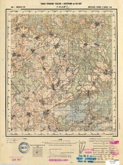
- Subject:
- Topical Subject: Soviet Union, Topical Subject: Maps, and Geographic Subject: Ruza
- Publisher:
- Главное Управление Геодезии и Картографии при СНК СССР
- Language:
- Russian
- Date Created:
- 1941
- Identifier:
- VAC9619-001988
- Genre:
- Military Maps and Topographic Maps
- Geographic Location:
- Coordinates: 55.6667, 36, 56, 36.5
- Related URL:
- Download GeoTIFF: https://drive.google.com/open?id=183z014zc6Fo65VnpwC5QfH0wkSz1d_qH and Catalog URL: https://iucat.iu.edu/catalog/5020129
- Abstract:
- Modern area represented: Ruza, Moscow oblast, Russia
- Call Number:
- G7000 s100 .S7 sheet N-37-1
- Caption:
- Для служебного пользования
- City:
- Руза (Ruza)
- Copyright Holder:
- No Copyright - United States
- Country:
- СССР (USSR)
- State/Province:
- Московская область (Moscow oblast) and РСФСР (RSFSR)
- Physical Description:
- Scale: 1:100,000
- Persistent URL:
- http://purl.dlib.indiana.edu/iudl/images/VAC9619/VAC9619-001988
- Provenance:
- DMA Topographic Center, Army Map Service Library, Geographic Names Branch, OMAHA
-
- Description:
- 1940
- Subject:
- Topical Subject: Maps, Topical Subject: Soviet Union, and Geographic Subject: Teploye
- Publisher:
- Главное Управление Геодезии и Картографии при СНК СССР
- Language:
- Russian
- Date Created:
- 1941
- Identifier:
- VAC9619-001622
- Genre:
- Topographic Maps and Military Maps
- Geographic Location:
- Coordinates: 53.167, 38.75, 53.333, 39
- Related URL:
- Catalog URL: http://iucat.iu.edu/catalog/5020131 and Download GeoTIFF: https://drive.google.com/open?id=1lM9vz8ka8KBnG2SoG43x4qVhM7_1oZq1
- Abstract:
- Modern area represented: Teploye, Lipetsk oblast, Russia
- Call Number:
- G7000 s50 .S68 sheet N-37-102-B
- Caption:
- Для служебного пользования
- City:
- Теплое (Teploye)
- Copyright Holder:
- No Copyright - United States
- Country:
- СССР (USSR)
- State/Province:
- РСФСР (RSFSR) and Рязанская область (Ryazan oblast)
- Physical Description:
- Scale: 1:50,000
- Persistent URL:
- http://purl.dlib.indiana.edu/iudl/images/VAC9619/VAC9619-001622
- Provenance:
- DMA Topographic Center, Army Map Service Library, OMAHA, Library of Congress Geography & Map Division
-
- Description:
- 1938
- Subject:
- Topical Subject: Soviet Union, Geographic Subject: Pankovichi, and Topical Subject: Maps
- Publisher:
- Главное Управление Геодезии и Картографии при СНК СССР
- Language:
- Russian
- Date Created:
- 1941
- Identifier:
- VAC9619-001608
- Genre:
- Topographic Maps and Military Maps
- Geographic Location:
- Coordinates: 54.1667, 37, 54.3333, 37.25
- Related URL:
- Download GeoTIFF: https://drive.google.com/open?id=1rgLWRpaPKy9SEGOhNTFp_2aPPdlfZMFk and Catalog URL: http://iucat.iu.edu/catalog/5020131
- Abstract:
- Modern area represented: Pankovichi, Tula oblast, Russia
- Call Number:
- G7000 s50 .S68 sheet N-37-63-A
- City:
- Панковичи (Pankovichi)
- Copyright Holder:
- No Copyright - United States
- Country:
- СССР (USSR)
- State/Province:
- Тульская область (Tula oblast) and РСФСР (RSFSR)
- Physical Description:
- Scale: 1:50,000
- Persistent URL:
- http://purl.dlib.indiana.edu/iudl/images/VAC9619/VAC9619-001608
- Provenance:
- Army Map Service Library, Library of Congress Geography & Map Division, OMAHA
-
- Description:
- 1939
- Subject:
- Topical Subject: Soviet Union, Topical Subject: Maps, and Geographic Subject: Bolshaya Azarovka
- Publisher:
- Главное Управление Геодезии и Картографии при СНК СССР
- Language:
- Russian
- Identifier:
- VAC9619-001283
- Genre:
- Topographic Maps and Military Maps
- Geographic Location:
- Coordinates: 55.1667, 34.5, 55.3333, 34.75
- Related URL:
- Catalog URL: http://iucat.iu.edu/catalog/5020131 and Download GeoTIFF: https://drive.google.com/open?id=14zIkYmsyFQgk6tEwJ78Cgwaue062mPCU
- Abstract:
- Modern area represented: Bolshaya Azarovka, Smolensk oblast, Russia
- Call Number:
- GM G7000 S50 .S68 N-36-34-A
- Copyright Holder:
- No Copyright - United States
- Country:
- СССР (USSR)
- State/Province:
- РСФСР (RSFSR) and Смоленская область (Smolensk oblast)
- Physical Description:
- Scale: 1:50,000
- Persistent URL:
- http://purl.dlib.indiana.edu/iudl/images/VAC9619/VAC9619-001283
- Provenance:
- CIA Map Branch -- Received
-
- Description:
- 1932
- Subject:
- Topical Subject: Maps, Geographic Subject: Pleshcheyevo, and Topical Subject: Soviet Union
- Publisher:
- Главное Управление Геодезии и Картографии при СНК СССР
- Language:
- Russian
- Date Created:
- 1941
- Identifier:
- VAC9619-001618
- Genre:
- Military Maps and Topographic Maps
- Geographic Location:
- Coordinates: 53, 36, 53.1667, 36.25
- Related URL:
- Download GeoTIFF: https://drive.google.com/open?id=1KSSYjZXUrx8fj81Xef4z7s0bWsy0M4gY and Catalog URL: http://iucat.iu.edu/catalog/5020131
- Abstract:
- Modern area represented: Pleshcheyevo, Oryol oblast, Russia
- Call Number:
- G7000 s50 .S68 sheet N-37-97-C
- Caption:
- Для служебного пользования
- City:
- Плещеево (Pleshcheyevo)
- Copyright Holder:
- No Copyright - United States
- Country:
- СССР (USSR)
- State/Province:
- РСФСР (RSFSR) and Орловская область (Oryol oblast)
- Physical Description:
- Scale: 1:50,000
- Persistent URL:
- http://purl.dlib.indiana.edu/iudl/images/VAC9619/VAC9619-001618
- Provenance:
- DMA Topographic Center, Army Map Service Library, Library of Congress Geography & Map Division
-
- Description:
- 1939
- Subject:
- Geographic Subject: Karpovo, Topical Subject: Maps, and Topical Subject: Soviet Union
- Publisher:
- Главное Управление Геодезии и Картографии при СНК СССР
- Language:
- Russian
- Identifier:
- VAC9619-001286
- Genre:
- Military Maps and Topographic Maps
- Geographic Location:
- Coordinates: 55, 34.75, 55.1667, 35
- Related URL:
- Catalog URL: http://iucat.iu.edu/catalog/5020131 and Download GeoTIFF: https://drive.google.com/open?id=1XlcQMtIZuRcF57Sk2_h1eNuLbc0cVF3m
- Abstract:
- Modern area represented: Karpovo, Smolensk oblast, Russia
- Call Number:
- GM G7000 S50 .S68 N-36-34-Г
- Copyright Holder:
- No Copyright - United States
- Country:
- СССР (USSR)
- State/Province:
- Смоленская область (Smolensk oblast) and РСФСР (RSFSR)
- Physical Description:
- Scale: 1:50,000
- Persistent URL:
- http://purl.dlib.indiana.edu/iudl/images/VAC9619/VAC9619-001286
- Provenance:
- CIA Map Branch -- Received
-
- Description:
- 1939
- Subject:
- Geographic Subject: Vyazma, Topical Subject: Maps, and Topical Subject: Soviet Union
- Publisher:
- Главное Управление Геодезии и Картографии при СНК СССР
- Language:
- Russian
- Date Created:
- 1941
- Identifier:
- VAC9619-001282
- Genre:
- Topographic Maps and Military Maps
- Geographic Location:
- Coordinates: 55.1667, 34.25, 55.3333, 34.5
- Related URL:
- Download GeoTIFF: https://drive.google.com/open?id=1SDJQ7cmOUSBIXLyC09KSuv37RZG4ZqVq and Catalog URL: http://iucat.iu.edu/catalog/5020131
- Abstract:
- Modern area represented: Vyazma, Smolensk oblast, Russia
- Call Number:
- GM G7000 S50 .S68 N-36-33-Б
- City:
- Вязьма (Vyazma)
- Copyright Holder:
- No Copyright - United States
- Country:
- СССР (USSR)
- State/Province:
- Смоленская область (Smolensk oblast) and РСФСР (RSFSR)
- Physical Description:
- Scale: 1:50,000
- Persistent URL:
- http://purl.dlib.indiana.edu/iudl/images/VAC9619/VAC9619-001282
- Provenance:
- DMA Topographic Center, Army Map Service Library, OMAHA, Library of Congress Geography & Map Division
-
- Description:
- 1940
- Subject:
- Topical Subject: Soviet Union, Topical Subject: Maps, and Geographic Subject: Skorodnoye
- Publisher:
- Главное Управление Геодезии и Картографии при СНК СССР
- Language:
- Russian
- Date Created:
- 1941
- Identifier:
- VAC9619-003381
- Genre:
- Military Maps and Topographic Maps
- Geographic Location:
- Coordinates: 51, 37, 51.333, 37.5
- Related URL:
- Catalog URL: https://iucat.iu.edu/catalog/5020129 and Download GeoTIFF: https://drive.google.com/file/d/1G4UWnnJBbvVb-WtNuv95PPm_L8Co7z7m/view?usp=sharing
- Abstract:
- Modern area represented: Skorodnoye, Kursk oblast, Russia
- Call Number:
- G7000 s100 .S7 sheet M-37-27
- City:
- Скородное (Skorodnoye)
- Copyright Holder:
- No Copyright - United States
- Country:
- СССР (USSR)
- State/Province:
- РСФСР (RSFSR) and Курская область (Kursk oblast)
- Physical Description:
- Scale: 1:100,000
- Persistent URL:
- http://purl.dlib.indiana.edu/iudl/images/VAC9619/VAC9619-003381
- Provenance:
- DMA Topographic Center, Army Map Service Library, OMAHA, Library of Congress Geography & Map Division
-
- Description:
- 1937
- Subject:
- Topical Subject: Maps, Geographic Subject: Zherlovo-Lukino, and Topical Subject: Soviet Union
- Publisher:
- Главное Управление Геодезии и Картографии при СНК СССР
- Language:
- Russian
- Date Created:
- 1941
- Identifier:
- VAC9619-001614
- Genre:
- Military Maps and Topographic Maps
- Geographic Location:
- Coordinates: 53.3333, 36.5, 53.5, 36.75
- Related URL:
- Catalog URL: http://iucat.iu.edu/catalog/5020131 and Download GeoTIFF: https://drive.google.com/open?id=1cewaYBgAC92RVplILzJrM-0fFOPw0q26
- Abstract:
- Modern area represented: Zherlovo-Lukino, Tula oblast, Russia
- Call Number:
- G7000 s50 .S68 sheet N-37-86-C
- Caption:
- Для служебного пользования
- Copyright Holder:
- No Copyright - United States
- Country:
- СССР (USSR)
- State/Province:
- РСФСР (RSFSR), Орловская область (Oryol oblast), and Тульская область (Tula oblast)
- Physical Description:
- Scale: 1:50,000
- Persistent URL:
- http://purl.dlib.indiana.edu/iudl/images/VAC9619/VAC9619-001614
- Provenance:
- DMA Topographic Center, Army Map Service Library, OMAHA, Library of Congress Geography & Map Division
-
- Description:
- 1939
- Subject:
- Geographic Subject: Sudzha, Topical Subject: Maps, and Topical Subject: Soviet Union
- Publisher:
- Главное Управление Геодезии и Картографии при СНК СССР
- Language:
- Russian
- Date Created:
- 1941
- Identifier:
- VAC9619-003278
- Genre:
- Military Maps and Topographic Maps
- Geographic Location:
- Coordinates: 51, 35, 51.333, 35.5
- Related URL:
- Download GeoTIFF: https://drive.google.com/file/d/1YEenHdsfsIBhqW-cICrUl7cvUJePSbJO/view?usp=sharing and Catalog URL: https://iucat.iu.edu/catalog/5020129
- Abstract:
- Modern area represented: Sudzha, Kursk oblast, Russia
- Call Number:
- G7000 s100 .S7 sheet M-36-35
- City:
- Суджа (Sudzha)
- Copyright Holder:
- No Copyright - United States
- Country:
- СССР (USSR)
- State/Province:
- РСФСР (RSFSR), Сумская область (Sumy oblast), Украинская ССР (Ukrainian Soviet Socialist Republic), and Курская область (Kursk oblast)
- Physical Description:
- Scale: 1:100,000
- Persistent URL:
- http://purl.dlib.indiana.edu/iudl/images/VAC9619/VAC9619-003278
- Provenance:
- DMA Topographic Center, Auswärtiges Amt. Geographischer Dienst, Army Map Service Library
-
- Description:
- 1939
- Subject:
- Geographic Subject: Khrenovaya, Topical Subject: Soviet Union, and Topical Subject: Maps
- Publisher:
- Главное Управление Геодезии и Картографии при СНК СССР
- Language:
- Russian
- Identifier:
- VAC9619-001211
- Genre:
- Topographic Maps and Military Maps
- Geographic Location:
- Coordinates: 55.8333, 34.5, 56, 34.75
- Related URL:
- Download GeoTIFF: https://drive.google.com/open?id=1k8U08OQuEFaqGZ2G0RysTK7KOBM0ITxc and Catalog URL: http://iucat.iu.edu/catalog/5020131
- Abstract:
- Modern area represented: Khrenovaya, Smolensk oblast, Russia
- Call Number:
- GM G7000 S50 .S68 N-36-10-A
- Copyright Holder:
- No Copyright - United States
- Country:
- СССР (USSR)
- State/Province:
- Калининская область (Kalinin oblast), РСФСР (RSFSR), and Смоленская область (Smolensk oblast)
- Physical Description:
- Scale: 1:50,000
- Persistent URL:
- http://purl.dlib.indiana.edu/iudl/images/VAC9619/VAC9619-001211
- Provenance:
- DMA Topographic Center, Army Map Service Library, OMAHA, Library of Congress Geography & Map Division
-

- Description:
- 1939
- Subject:
- Geographic Subject: Igorevskaya, Topical Subject: Soviet Union, and Topical Subject: Maps
- Publisher:
- Главное Управление Геодезии и Картографии при СНК СССР
- Language:
- Russian
- Date Created:
- 1941
- Identifier:
- VAC9619-001240
- Genre:
- Military Maps and Topographic Maps
- Geographic Location:
- Coordinates: 55.333, 33.25, 55.5, 33.5
- Related URL:
- Catalog URL: http://iucat.iu.edu/catalog/5020131 and Download GeoTIFF: https://drive.google.com/open?id=19Ny6usJ7h1VBfqfIJZgXWbFqU2oA3KSv
- Abstract:
- Modern area represented: Igorevskaya, Smolensk oblast, Russia
- Call Number:
- GM G7000 S50 .S68 N-36-19-D
- Copyright Holder:
- No Copyright - United States
- Country:
- СССР (USSR)
- State/Province:
- РСФСР (RSFSR) and Смоленская область (Smolensk oblast)
- Physical Description:
- Scale: 1:50,000
- Persistent URL:
- http://purl.dlib.indiana.edu/iudl/images/VAC9619/VAC9619-001240
- Provenance:
- DMA Topographic Center, Army Map Service Library, OMAHA, Library of Congress Geography & Map Division
-
- Description:
- 1939
- Subject:
- Topical Subject: Maps and Topical Subject: Soviet Union
- Publisher:
- Главное Управление Геодезии и Картографии при СНК СССР
- Language:
- Russian
- Identifier:
- VAC9619-001288
- Genre:
- Topographic Maps and Military Maps
- Geographic Location:
- Coordinates: 55, 35.25, 55.1667, 35.5
- Related URL:
- Download GeoTIFF: https://drive.google.com/open?id=1UWfrVIbqM3a59nmdUaXDlHKpGMsKKVII and Catalog URL: http://iucat.iu.edu/catalog/5020131
- Abstract:
- Modern area represented:
- Call Number:
- GM G7000 S50 .S68 N-36-35-Г
- Copyright Holder:
- No Copyright - United States
- Country:
- СССР (USSR)
- State/Province:
- РСФСР (RSFSR) and Смоленская область (Smolensk oblast)
- Physical Description:
- Scale: 1:50,000
- Persistent URL:
- http://purl.dlib.indiana.edu/iudl/images/VAC9619/VAC9619-001288
- Provenance:
- DMA Topographic Center, Army Map Service Library, OMAHA, Library of Congress Geography & Map Division
-
- Description:
- 1940
- Subject:
- Topical Subject: Maps, Geographic Subject: Voskresenskoye, and Topical Subject: Soviet Union
- Publisher:
- Главное Управление Геодезии и Картографии при СНК СССР
- Language:
- Russian
- Date Created:
- 1941
- Identifier:
- VAC9619-001621
- Genre:
- Topographic Maps and Military Maps
- Geographic Location:
- Coordinates: 53.167, 38.5, 53.333, 38.75
- Related URL:
- Download GeoTIFF: https://drive.google.com/open?id=1P42W8VzHcjf1s09sLj4-0gdmibUZvSEx and Catalog URL: http://iucat.iu.edu/catalog/5020131
- Abstract:
- Modern area represented: Voskresenskoye, Lipetsk oblast, Russia
- Call Number:
- G7000 s50 .S68 sheet N-37-102-A
- Caption:
- Для служебного пользования
- City:
- Воскресенское (Voskresenskoye)
- Copyright Holder:
- No Copyright - United States
- Country:
- СССР (USSR)
- State/Province:
- РСФСР (RSFSR), Тульская область (Tula oblast), and Рязанская область (Ryazan oblast)
- Physical Description:
- Scale: 1:50,000
- Persistent URL:
- http://purl.dlib.indiana.edu/iudl/images/VAC9619/VAC9619-001621
- Provenance:
- DMA Topographic Center, Army Map Service Library, Library of Congress Geography & Map Division
-
- Description:
- 1938
- Subject:
- Topical Subject: Maps, Topical Subject: Soviet Union, and Geographic Subject: Semënovka
- Publisher:
- Главное Управление Геодезии и Картографии при СНК СССР
- Language:
- Russian
- Identifier:
- VAC9619-004215
- Genre:
- Military Maps and Topographic Maps
- Geographic Location:
- Coordinates: 52, 32.5, 52.333, 33
- Related URL:
- Download GeoTIFF: https://drive.google.com/file/d/1fV1jj8bxfosoNzFaEIgOetNrQvRV5gum/view?usp=sharing and Catalog URL: https://iucat.iu.edu/catalog/5020129
- Abstract:
- Modern area represented: Semënovka, Russia
- Call Number:
- G7000 s100 .S7 sheet N-36-138
- Caption:
- Для служебного пользования
- City:
- Семеновка (Semënovka)
- Copyright Holder:
- No Copyright - United States
- Country:
- СССР (USSR)
- State/Province:
- Украинская ССР (Ukrainian Soviet Socialist Republic), Орловская область (Oryol oblast), РСФСР (RSFSR), and Черниговская область (Chernihiv oblast)
- Physical Description:
- Scale: 1:100,000
- Persistent URL:
- http://purl.dlib.indiana.edu/iudl/images/VAC9619/VAC9619-004215
- Provenance:
- DMA Topographic Center, Army Map Service Library, OMAHA, Atlasblatt, Library of Congress Geography & Map Division, Geographic Names Branch
-
- Description:
- 1938
- Subject:
- Geographic Subject: Bakhmut, Topical Subject: Maps, and Topical Subject: Soviet Union
- Publisher:
- Главное Управление Геодезии и Картографии при СНК СССР
- Language:
- Russian
- Date Created:
- 1941
- Identifier:
- VAC9619-003402
- Genre:
- Topographic Maps and Military Maps
- Geographic Location:
- Coordinates: 48.333, 38, 48.667, 38.5
- Related URL:
- Catalog URL: https://iucat.iu.edu/catalog/5020129 and Download GeoTIFF: https://drive.google.com/file/d/1veqRoyXKWLTyGzEBtYxvII6h1ZdoVJBC/view?usp=sharing
- Abstract:
- Modern area represented: Bakhmut, Donetsk oblast, Ukraine
- Call Number:
- G7000 s100 .S7 sheet M-37-125
- Caption:
- Для служебного пользования
- City:
- Артемовск (Artemivsk)
- Copyright Holder:
- No Copyright - United States
- Country:
- СССР (USSR)
- State/Province:
- Сталинская область (Stalino oblast), Украинская ССР (Ukrainian Soviet Socialist Republic), and Ворошиловградская область (Voroshilovgrad oblast)
- Physical Description:
- Scale: 1:100,000
- Persistent URL:
- http://purl.dlib.indiana.edu/iudl/images/VAC9619/VAC9619-003402
- Provenance:
- Army Map Service Library, Library of Congress G & M Division, Geographic Names Branch
-
- Description:
- 1939
- Subject:
- Topical Subject: Soviet Union, Geographic Subject: Novodugino, and Topical Subject: Maps
- Publisher:
- Главное Управление Геодезии и Картографии при СНК СССР
- Language:
- Russian
- Date Created:
- 1941
- Identifier:
- VAC9619-001246
- Genre:
- Topographic Maps and Military Maps
- Geographic Location:
- Coordinates: 55.5, 34.25, 55.667, 34.5
- Related URL:
- Download GeoTIFF: https://drive.google.com/open?id=1qAe3OevCswzdF6iott1gix8gassGb4go and Catalog URL: http://iucat.iu.edu/catalog/5020131
- Abstract:
- Modern area represented: Novodugino, Smolensk oblast, Russia
- Call Number:
- GM G7000 S50 .S68 N-36-21-Б
- Copyright Holder:
- No Copyright - United States
- Country:
- СССР (USSR)
- State/Province:
- Смоленская область (Smolensk oblast) and РСФСР (RSFSR)
- Physical Description:
- Scale: 1:50,000
- Persistent URL:
- http://purl.dlib.indiana.edu/iudl/images/VAC9619/VAC9619-001246
- Provenance:
- DMA Topographic Center, Army Map Service Library, OMAHA, Library of Congress Geography & Map Division
-
- Description:
- 1932
- Subject:
- Geographic Subject: Novosil, Topical Subject: Soviet Union, and Topical Subject: Maps
- Publisher:
- Главное Управление Геодезии и Картографии при СНК СССР
- Language:
- Russian
- Date Created:
- 1941
- Identifier:
- VAC9619-001627
- Genre:
- Topographic Maps and Military Maps
- Geographic Location:
- Coordinates: 52.833, 37, 53, 37.25
- Related URL:
- Download GeoTIFF: https://drive.google.com/open?id=1r4rcYgTn5yNIEhiZBIkimBCF43d0UQ36 and Catalog URL: http://iucat.iu.edu/catalog/5020131
- Abstract:
- Modern area represented: Novosil, Oryol oblast, Russia
- Call Number:
- G7000 s50 .S68 sheet N-37-111-A
- Caption:
- Для служебного пользования
- City:
- Новосиль (Novosil)
- Copyright Holder:
- No Copyright - United States
- Country:
- СССР (USSR)
- State/Province:
- Орловская область (Oryol oblast) and РСФСР (RSFSR)
- Physical Description:
- Scale: 1:50,000
- Persistent URL:
- http://purl.dlib.indiana.edu/iudl/images/VAC9619/VAC9619-001627
- Provenance:
- DMA Topographic Center, Army Map Service Library, OMAHA, Library of Congress Geography & Map Division
-
- Description:
- 1931
- Subject:
- Geographic Subject: Sergo-Ivanovskoye, Topical Subject: Maps, and Topical Subject: Soviet Union
- Publisher:
- Главное Управление Геодезии и Картографии при СНК СССР
- Language:
- Russian
- Date Created:
- 1939
- Identifier:
- VAC9619-001249
- Genre:
- Topographic Maps and Military Maps
- Geographic Location:
- Coordinates: 55.333, 34.75, 55.5, 35
- Related URL:
- Catalog URL: http://iucat.iu.edu/catalog/5020131 and Download GeoTIFF: https://drive.google.com/open?id=1I4WtzVhDUv8DMq8HMjP3CELjH84G2X10
- Abstract:
- Modern area represented: Sergo-Ivanovskoye, Smolensk oblast, Russia
- Call Number:
- GM G7000 S50 .S68 N-36-22-Г
- City:
- Серго-Ивановский (Sergo-Ivanovskiy)
- Copyright Holder:
- No Copyright - United States
- Country:
- СССР (USSR)
- State/Province:
- РСФСР (RSFSR) and Смоленская область (Smolensk oblast)
- Physical Description:
- Scale: 1:50,000
- Persistent URL:
- http://purl.dlib.indiana.edu/iudl/images/VAC9619/VAC9619-001249
- Provenance:
- DMA Topographic Center, Army Map Service Library, OMAHA, Library of Congress Geography & Map Division
-
- Description:
- 1939
- Subject:
- Topical Subject: Maps, Geographic Subject: Vadino, and Topical Subject: Soviet Union
- Publisher:
- Главное Управление Геодезии и Картографии при СНК СССР
- Language:
- Russian
- Date Created:
- 1941
- Identifier:
- VAC9619-001274
- Genre:
- Military Maps and Topographic Maps
- Geographic Location:
- Coordinates: 55.1667, 33.25, 55.3333, 33.5
- Related URL:
- Catalog URL: http://iucat.iu.edu/catalog/5020131 and Download GeoTIFF: https://drive.google.com/open?id=1bRMhpgRLtg-0twjQi8rnu1HJSnFE6Duv
- Abstract:
- Modern area represented: Vadino, Smolensk oblast, Russia
- Call Number:
- GM G7000 S50 .S68 N-36-31-Б
- Copyright Holder:
- No Copyright - United States
- Country:
- СССР (USSR)
- State/Province:
- Смоленская область (Smolensk oblast) and РСФСР (RSFSR)
- Physical Description:
- Scale: 1:50,000
- Persistent URL:
- http://purl.dlib.indiana.edu/iudl/images/VAC9619/VAC9619-001274
- Provenance:
- DMA Topographic Center, Army Map Service Library, OMAHA, Library of Congress Geography & Map Division
-
- Description:
- 1940
- Subject:
- Geographic Subject: Bolshetroitskoye, Topical Subject: Soviet Union, and Topical Subject: Maps
- Publisher:
- Главное Управление Геодезии и Картографии при СНК СССР
- Language:
- Russian
- Date Created:
- 1941
- Identifier:
- VAC9619-003387
- Genre:
- Military Maps and Topographic Maps
- Geographic Location:
- Coordinates: 50.333, 37, 50.667, 37.5
- Related URL:
- Download GeoTIFF: https://drive.google.com/file/d/1Sy1mBMGYvqqz0pzlHcvGjxKjo3ANez5Y/view?usp=sharing and Catalog URL: https://iucat.iu.edu/catalog/5020129
- Abstract:
- Modern area represented: Bolshetroitskoye, Belgorod oblast, Russia
- Call Number:
- G7000 s100 .S7 sheet M-37-51
- City:
- Больше-Троицкое (Bolshe-Troitskoye)
- Copyright Holder:
- No Copyright - United States
- Country:
- СССР (USSR)
- State/Province:
- Харьковская область (Kharkiv oblast), Курская область (Kursk oblast), Украинская ССР (Ukrainian Soviet Socialist Republic), and РСФСР (RSFSR)
- Physical Description:
- Scale: 1:100,000
- Persistent URL:
- http://purl.dlib.indiana.edu/iudl/images/VAC9619/VAC9619-003387
- Provenance:
- Army Map Service Library, Library of Congress G & M Division, Geographic Names Branch
-
- Description:
- 1938
- Subject:
- Geographic Subject: Bolshevo, Topical Subject: Maps, and Topical Subject: Soviet Union
- Publisher:
- Главное Управление Геодезии и Картографии при СНК СССР
- Language:
- Russian
- Date Created:
- 1941
- Identifier:
- VAC9619-001208
- Genre:
- Topographic Maps and Military Maps
- Geographic Location:
- Coordinates: 55.6667, 33.75, 55.8333, 34
- Related URL:
- Download GeoTIFF: https://drive.google.com/open?id=1zB90p3B2RIsyk-mJhD7yBbqo8PeBT3-H and Catalog URL: http://iucat.iu.edu/catalog/5020131
- Abstract:
- Modern area represented: Bolshevo, Smolensk oblast, Russia
- Call Number:
- GM G7000 S50 .S68 N-36-8-Г
- Copyright Holder:
- No Copyright - United States
- Country:
- СССР (USSR)
- State/Province:
- Смоленская область (Smolensk oblast) and РСФСР (RSFSR)
- Physical Description:
- Scale: 1:50,000
- Persistent URL:
- http://purl.dlib.indiana.edu/iudl/images/VAC9619/VAC9619-001208
- Provenance:
- Army Map Service Library, Library of Congress Geography & Map Division, OMAHA
-
- Description:
- 1934
- Subject:
- Topical Subject: Soviet Union, Topical Subject: Maps, and Geographic Subject: Noviy Azov
- Publisher:
- Главное Управление Геодезии и Картографии при СНК СССР
- Language:
- Russian
- Date Created:
- 1936
- Identifier:
- VAC9619-001924
- Genre:
- Topographic Maps and Military Maps
- Geographic Location:
- Coordinates: 46, 35, 46.3333, 35.5
- Related URL:
- Download GeoTIFF: https://drive.google.com/open?id=1kXYrv1G8OZSvZdSM2SJdkDOcDlraF50I and Catalog URL: https://iucat.iu.edu/catalog/5020129
- Abstract:
- Modern area represented: Noviy Azov, Kherson oblast, Ukraine
- Call Number:
- G7000 s100 .S7 sheet L-36-71
- Caption:
- Для служебного пользования
- City:
- Нов. Азов (Noviy Azov)
- Copyright Holder:
- No Copyright - United States
- Country:
- СССР (USSR)
- State/Province:
- Запорожская область (Zaporizhia oblast) and Украинская ССР (Ukrainian Soviet Socialist Republic)
- Physical Description:
- Scale: 1:100,000
- Persistent URL:
- http://purl.dlib.indiana.edu/iudl/images/VAC9619/VAC9619-001924
- Provenance:
- CIA Map Library
-
- Description:
- 1938
- Subject:
- Geographic Subject: Kolezhma, Topical Subject: Maps, and Topical Subject: Soviet Union
- Publisher:
- Главное Управление Геодезии и Картографии при СНК СССР
- Language:
- Russian
- Date Created:
- 1941
- Identifier:
- VAC9619-002629
- Genre:
- Military Maps and Topographic Maps
- Geographic Location:
- Coordinates: 64, 35.5, 64.333, 36
- Related URL:
- Catalog URL: https://iucat.iu.edu/catalog/5020129 and Download GeoTIFF: https://drive.google.com/file/d/1UTip26nPXX54soudKYxJfU64NIEZnnyK/view?usp=sharing
- Abstract:
- Modern area represented: Kolezhma, Republic of Karelia, Russia
- Call Number:
- G7000 s100 .S7 sheet Q-36-144
- Caption:
- Для служебного пользования
- City:
- Колежма (Kolezhma)
- Copyright Holder:
- No Copyright - United States
- Country:
- СССР (USSR)
- State/Province:
- Карело-Финская ССР (Karelo-Finnish Soviet Socialist Republic)
- Physical Description:
- Scale: 1:100,000
- Persistent URL:
- http://purl.dlib.indiana.edu/iudl/images/VAC9619/VAC9619-002629
- Provenance:
- DMA Topographic Center, Army Map Service Library, OMAHA, Geographic Names Branch

- « Previous
- Next »
- 1
- 2
- 3