
Search Constraints
You searched for:
Publisher
Indiana. Department of Geology and Natural Resources
Remove constraint Publisher: Indiana. Department of Geology and Natural Resources
Subject
Topical Subject: Geology, Stratigraphic
Remove constraint Subject: Topical Subject: Geology, Stratigraphic
Search Results
-
- Subject:
- Topical Subject: IGS Annual Reports, Topical Subject: Coal reserves, Topical Subject: Coalfields, Topical Subject: Stratigraphic correlation, Geographic Subj...
- Publisher:
- Indiana. Department of Geology and Natural Resources
- Date Created:
- 1899
- Identifier:
- VAC3073-M-00691
- Genre:
- Geological cross-sections and Geological maps
- Geographic Location:
- Coordinates: W0865330 W0864630 N0384130 N0383830
- Related URL:
- Catalog URL: https://iucat.iu.edu/catalog/18214656
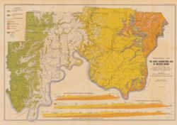
- Abstract:
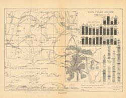
- Relief shown by profile. Includes index map showing locations of coal fields in southern Martin County, 29 stratigraphic columns, correlation lines, and 4 ge...
- Call Number:
- G4093.M5H9 1898 .C63
- Caption:
- Imprint: [Indianapolis] : [Indiana Department of Geology and Natural Resources], [1899]
- Physical Description:
- Scale: Approximately 1:63,360 and Dimensions: 21 x 27 cm
- Alternate Identifier:
- Alternate ID: 390726IP and Title Control Number: a18214656
- Persistent URL:
- https://purl.dlib.indiana.edu/iudl/images/VAC3073/VAC3073-M-00691
- Provenance:
- 23rd Annual Report (1898) / Indiana. Department of Geology and Natural Resources.
-
- Subject:
- Geographic Subject: Wayne County (Ind.), Topical Subject: Geology, Topical Subject: Paleontology, Geographic Subject: Tanners Creek (Ind. : Creek), Topical S...
- Creator:
- Cumings, E. R. (Edgar Roscoe), 1874-1967
- Publisher:
- Indiana. Department of Geology and Natural Resources
- Date Created:
- 1908
- Identifier:
- VAC3073-M-00692
- Genre:
- Graphs
- Geographic Location:
- Coordinates: W0845749 W0844849 N0395257 N0390333
- Related URL:
- Catalog URL: https://iucat.iu.edu/catalog/18298805
- Abstract:
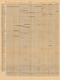
- Title derived from captions. Chart showing stratigraphic measurements for paleontology samples collected around Tanner's Creek in Dearborn County and Ric...
- Call Number:
- G4091.C57 1908 .C86
- Caption:
- Imprint: [Indianapolis] : [Indiana Dept. of Geology and Natural Resources], [1908]
- Physical Description:
- Dimensions: 63 x 48 cm
- Alternate Identifier:
- Title Control Number: a18298805 and Alternate ID: 390726IP
- Persistent URL:
- https://purl.dlib.indiana.edu/iudl/images/VAC3073/VAC3073-M-00692
- Provenance:
- 32nd Annual Report (1907) / Indiana. Department of Geology and Natural Resources.
-
- Subject:
- Topical Subject: Geology, Geographic Subject: Indiana, and Topical Subject: Geology, Stratigraphic
- Creator:
- Newsom, John F. (John Flesher), 1869-1928
- Publisher:
- Indiana. Department of Geology and Natural Resources
- Date Created:
- 1902
- Identifier:
- VAC3073-M-00678
- Genre:
- Geological maps, Topographic maps, Strip maps, and Geological cross-sections
- Geographic Location:
- Coordinates: W0873650 W0852050 N0384430 N0383730
- Related URL:
- Catalog URL: https://iucat.iu.edu/catalog/16077374
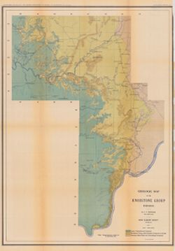
- Abstract:
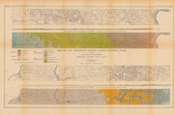
- Relief shown by contours. "Contour interval 40 feet." "Plate II." Detached from: A geologic and topographic section across Southern In...
- Call Number:
- G4091.C5 1901 .N41
- Caption:
- Imprint: Indianapolis, Ind. : Wm. B. Burford,[1902] and Imprint: [Indianapolis] : Department of Geology and Natural Resources of Indiana, [1902]
- Physical Description:
- Scale: Approximately 1:126,720. 2 miles = 1 in. Vertical scale approximately 1:24,000. 2,000 feet = 1 in. and Dimensions: 8 x 156 cm each, on sheet 56 x 84 cm
- Alternate Identifier:
- Title Control Number: a16077374 and Alternate ID: 390726IP
- Persistent URL:
- https://purl.dlib.indiana.edu/iudl/images/VAC3073/VAC3073-M-00678
- Provenance:
- 26th Annual Report (1901) / Indiana. Department of Geology and Natural Resources.
-
- Subject:
- Topical Subject: Coal, Topical Subject: Geology, Stratigraphic, Topical Subject: IGS Annual Reports, and Geographic Subject: Indiana
- Creator:
- Ashley, Geo. H. (George Hall), 1866-1951
- Publisher:
- Indiana. Department of Geology and Natural Resources
- Date Created:
- 1909
- Identifier:
- VAC3073-M-00650
- Genre:
- Geological cross-sections
- Geographic Location:
- Coordinates: W0880500 W0844700 N0414500 N0374600
- Related URL:
- Catalog URL: https://iucat.iu.edu/catalog/18307698
- Abstract:
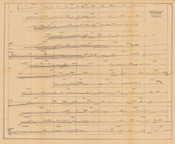
- 15 sections on one sheet. Detached from: The coal deposits of Indiana : a supplemental report to the one issued in 1898 / George H. Ashley. In Indiana Dep...
- Call Number:
- QE109 .A2 1908
- Caption:
- Imprint: [Indianapolis] : [Indiana Department of Geology and Natural Resources], [1909]
- Physical Description:
- Dimensions: 44 x 53 cm and Scale: Approximately 1:126,720. 2 miles = 1 inch. Vertical scale approximately 1:12,000. 1,000 feet = 1 inch
- Alternate Identifier:
- Title Control Number: a18307698 and Alternate ID: 390726IP
- Persistent URL:
- https://purl.dlib.indiana.edu/iudl/images/VAC3073/VAC3073-M-00650
- Provenance:
- 33rd Annual Report (1908) / Indiana. Department of Geology and Natural Resources.
-
![Township 2 south, range 7 west [Indiana]](https://iiif.uits.iu.edu/iiif/2/2b88rf889%2Ffiles%2F8503c6af-2a95-4ca4-acde-dcd4736a0d0c/full/250,/0/default.jpg)
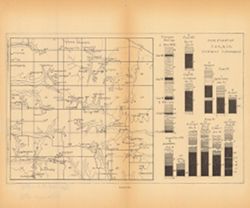
- Subject:
- Topical Subject: Coal reserves, Geographic Subject: Pike County (Ind.), Topical Subject: Geology, Stratigraphic, and Topical Subject: IGS Annual Reports
- Publisher:
- Indiana. Department of Geology and Natural Resources
- Date Created:
- 1899
- Identifier:
- VAC3073-M-00614
- Genre:
- Geological cross-sections and Geological maps
- Geographic Location:
- Coordinates: W0871432 W0870735 N0382243 N0381721
- Related URL:
- Catalog URL: http://www.iucat.iu.edu/catalog/18418128
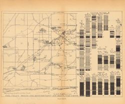
- Abstract:
- Relief shown by profile. Other title from Bureau of Land Management database: IN T2S R7W. 20 columnar sections showing coal measures and location map for unn...
- Call Number:
- G4093.P4H9 1898 .T6
- Caption:
- Imprint: [Indianapolis] : [Wm. B. Burford], [1899] and Imprint: [Indianapolis] : [Indiana, Dept. of Geology and Natural History], [1899]
- Physical Description:
- Dimensions: 23 x 27 cm and Scale: Approximately 1:63,360. Vertical scale not given
- Alternate Identifier:
- Title Control Number: a18418128 and Alternate ID: 390726IP
- Persistent URL:
- https://purl.dlib.indiana.edu/iudl/images/VAC3073/VAC3073-M-00614
- Provenance:
- 23rd Annual Report (1898) / Indiana. Department of Geology and Natural Resources.
-
- Subject:
- Topical Subject: Geology, Stratigraphic, Topical Subject: Geology, Geographic Subject: Indiana, Topical Subject: Mines and mineral resources, and Topical Sub...
- Creator:
- Ashley, Geo. H. (George Hall), 1866-1951, Blatchley, W. S. (Willis Stanley), 1859-1940, and Kindle, E. M. (Edward Martin), 1869-1940
- Publisher:
- Indiana. Department of Geology and Natural Resources
- Date Created:
- 1903
- Identifier:
- VAC3073-M-00394
- Genre:
- Geological cross-sections and Geological maps
- Geographic Location:
- Coordinates: W0864835 W0854540 N0382520 N0375015
- Related URL:
- Catalog URL: https://iucat.iu.edu/catalog/16076820
- Abstract:
- From the 27th Annual report of the Department of Geology and Natural Resources of Indiana, 1902. Includes three East-West cross-sections: through New Amsterd...
- Call Number:
- G4091.C5 1902 .A81
- Caption:
- Imprint: [Indianapolis] : [Wm. B. Burford], [1903] and Imprint: [Indianapolis] : [Indiana Department of Geology and Natural Resources], [1902]
- Physical Description:
- Scale: Approximately 1:126,720. 2 miles = 1 in. Vertical scale approximately 1:9,600. 800 feet = 1 in. and Dimensions: 51 x 76 cm, on sheet 56 x 80 cm
- Alternate Identifier:
- Title Control Number: a16076820 and Alternate ID: 390726IP
- Persistent URL:
- https://purl.dlib.indiana.edu/iudl/images/VAC3073/VAC3073-M-00394
- Provenance:
- 27th Annual Report (1902) / Indiana. Department of Geology and Natural Resources.
-
- Subject:
- Topical Subject: Mines and mineral resources, Topical Subject: Geology, Geographic Subject: Indiana, Topical Subject: Geology, Stratigraphic, and Topical Sub...
- Creator:
- Newsom, John F. (John Flesher), 1869-1928
- Publisher:
- Indiana. Department of Geology and Natural Resources
- Date Created:
- 1902
- Identifier:
- VAC3073-M-00381
- Genre:
- Geological maps
- Geographic Location:
- Coordinates: W0863410 W0853500 N0390430 N0375720
- Related URL:
- Catalog URL: https://iucat.iu.edu/catalog/16077083
- Abstract:
- Relief shown by contour lines. "Plate III." Detached from: A geologic and topographic section across Southern Indiana / by J. F. Newsom. In Indi...
- Call Number:
- G4091.C5 1901 .N43
- Caption:
- Imprint: [Indianapolis, Ind.] : [Indiana Department of Geology and Natural Resources], [1901] and Imprint: Indianapolis, Ind. : Wm. B. Burford, [1902]
- Physical Description:
- Scale: Scale approximately 1:190,080. 3 miles = 1 in. and Dimensions: 69 x 49 cm, on sheet 76 x 52 cm
- Alternate Identifier:
- Title Control Number: a16077083 and Alternate ID: 390726IP
- Persistent URL:
- https://purl.dlib.indiana.edu/iudl/images/VAC3073/VAC3073-M-00381
- Provenance:
- 26th Annual Report (1901) / Indiana. Department of Geology and Natural Resources.
-
- Subject:
- Geographic Subject: Vigo County (Ind.), Topical Subject: Geology, Stratigraphic, Topical Subject: Coal reserves, Topical Subject: IGS Annual Reports, and Top...
- Publisher:
- Indiana. Department of Geology and Natural Resources
- Date Created:
- 1899
- Identifier:
- VAC3073-M-00303
- Genre:
- Geological cross-sections and Geological maps
- Geographic Location:
- Coordinates: W0872400 W0865700 N0393900 N0393000
- Related URL:
- Catalog URL: https://iucat.iu.edu/catalog/18214647
- Abstract:
- Relief shown by profile. Includes map showing locations of coal fields in Vigo County, Indiana, as well as 2 geological cross sections along the north and so...
- Call Number:
- G4093.V5H9 1898 .C63
- Caption:
- Imprint: [Indianapolis] : [Indiana Department of Geology and Natural Resources], [1899]
- Physical Description:
- Scale: Approximately 1:63,360. Vertical scale varies and Dimensions: 23 x 27 cm
- Alternate Identifier:
- Title Control Number: a18214647 and Alternate ID: 390726IP
- Persistent URL:
- https://purl.dlib.indiana.edu/iudl/images/VAC3073/VAC3073-M-00303
- Provenance:
- 23rd Annual Report (1898) / Indiana. Department of Geology and Natural Resources.
-
- Subject:
- Topical Subject: Coal reserves, Geographic Subject: Jefferson (Ind. : Township), Topical Subject: IGS Annual Reports, and Topical Subject: Geology, Stratigra...
- Publisher:
- Indiana. Department of Geology and Natural Resources
- Date Created:
- 1899
- Identifier:
- VAC3073-M-00285
- Genre:
- Geological maps and Geological cross-sections
- Geographic Location:
- Coordinates: W0870430 W0865115 N0391900 N0391000
- Related URL:
- Catalog URL: https://iucat.iu.edu/catalog/18418134
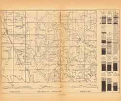
- Abstract:
- Relief shown by profile. 13 columnar sections showing coal measures and location map for Jefferson Township, including Coal City and Arney, in Owen County, I...
- Call Number:
- G4094.J384H9 1898 .C63
- Caption:
- Imprint: [Indianapolis] : [Wm. B. Burford], [1899] and Imprint: [Indianapolis] : [Indiana, Dept. of Geology and Natural History], [1899]
- Physical Description:
- Dimensions: 23 x 27 cm and Scale: Approximately 1:63,360. Vertical scale varies
- Alternate Identifier:
- Alternate ID: 390726IP and Title Control Number: a18418134
- Persistent URL:
- https://purl.dlib.indiana.edu/iudl/images/VAC3073/VAC3073-M-00285
- Provenance:
- 23rd Annual Report (1898) / Indiana. Department of Geology and Natural Resources.
-
- Subject:
- Topical Subject: Coal reserves, Topical Subject: IGS Annual Reports, Topical Subject: Geology, Stratigraphic, and Geographic Subject: Wright (Ind. : Township)
- Publisher:
- Indiana. Department of Geology and Natural Resources
- Date Created:
- 1899
- Identifier:
- VAC3073-M-00282
- Genre:
- Geological maps and Geological cross-sections
- Geographic Location:
- Coordinates: W0871435 W0870743 N0391018 N0390513
- Related URL:
- Catalog URL: https://iucat.iu.edu/catalog/18417962
- Abstract:
- 13 columnar sections showing coal measures with location map for Wright Township in Greene County, Indiana. Plate XL. Detached from: The coal deposits of ...
- Call Number:
- G4094.W79H9 1898 .I5
- Caption:
- Imprint: [Indianapolis] : [Wm. B. Burford], [1899] and Imprint: [Indianapolis] : [Indiana. Department of Geology and Natural Resources], [1899]
- Physical Description:
- Dimensions: 23 x 27 cm and Scale: Approximately 1:63,360. Vertical scale varies
- Alternate Identifier:
- Alternate ID: 390726IP and Title Control Number: a18417962
- Persistent URL:
- https://purl.dlib.indiana.edu/iudl/images/VAC3073/VAC3073-M-00282
- Provenance:
- 23rd Annual Report (1898) / Indiana. Department of Geology and Natural Resources.

- « Previous
- Next »
- 1
- 2
- 3
- 4