Geographic Subject: Bloomington (Ind.), Geographic Subject: Monroe County (Ind.), and Topical Subject: Census districts
Creator:
United States. Bureau of the Census
Publisher:
United States. Bureau of the Census
Date Created:
1974
Identifier:
VAC3073-M-00892
Genre:
Census data and Thematic maps
Geographic Location:
Coordinates: W0864108 W0861902 N0392120 N0385926
Related URL:
Catalog URL: https://iucat.iu.edu/catalog/5300402
Abstract:
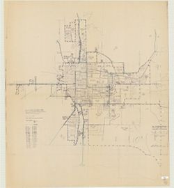
Blue line print. Shows 1970 census enumeration districts and census tracts for Bloomington, Ind. "Traced from map no. 68-A-8776." "70-...
Call Number:
G4094.B5 E25 1970 .U5
Caption:
Imprint: [Jeffersonville, Ind.] : Bureau of the Census, [1974?]