
Search Constraints
You searched for:
Provenance
32nd Annual Report (1907) / Indiana. Department of Geology and Natural Resources.
Remove constraint Provenance: 32nd Annual Report (1907) / Indiana. Department of Geology and Natural Resources.
Publisher
Indiana. Department of Geology and Natural Resources
Remove constraint Publisher: Indiana. Department of Geology and Natural Resources
« Previous |
1 - 10 of 24
|
Next »
Search Results
-
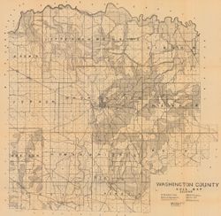
- Subject:
- Geographic Subject: Washington County (Ind.) and Topical Subject: Soils
- Creator:
- Indiana. Department of Geology and Natural Resources
- Publisher:
- Indiana. Department of Geology and Natural Resources
- Date Created:
- 1908
- Identifier:
- VAC3073-M-00603
- Genre:
- Thematic maps
- Geographic Location:
- Coordinates: W0861836 W0855051 N0384700 N0382504
- Related URL:
- Catalog URL: https://iucat.iu.edu/catalog/16096233
- Abstract:
- Shows railroads, dirt roads, improved roads, school houses, and churches. Detached from: Soil survey of Monroe, Brown, Lawrence, Martin, Orange, Washingto...
- Call Number:
- G4093.W5J3 1907 .I53
- Caption:
- Imprint: [Indianapolis] : [Indiana Department of Geology and Natural Resources], [1908]
- Physical Description:
- Scale: Approximately 1:63,360 and Dimensions: 67 x 68 cm
- Alternate Identifier:
- Title Control Number: a16096233 and Alternate ID: 390726IP
- Persistent URL:
- https://purl.dlib.indiana.edu/iudl/images/VAC3073/VAC3073-M-00603
- Provenance:
- 32nd Annual Report (1907) / Indiana. Department of Geology and Natural Resources.
-

- Subject:
- Geographic Subject: Indiana, Topical Subject: IGS Annual Reports, and Topical Subject: Geology, Stratigraphic--Ordovician
- Creator:
- Cumings, E. R. (Edgar Roscoe), 1874-1967
- Publisher:
- Indiana. Department of Geology and Natural Resources
- Date Created:
- 1908
- Identifier:
- VAC3073-M-00874
- Genre:
- Geological cross-sections
- Geographic Location:
- Coordinates: W0880500 W0844700 N0414500 N0374600
- Related URL:
- Catalog URL: https://iucat.iu.edu/catalog/18307667
- Abstract:
- 3 sections on one sheet. Title from caption. Shows strategraphic measurements for sections 5.9A, 1.38A, and 1.38B. Detached from: The stratigraphy and pal...
- Call Number:
- G4091.C57 1907 .Z47
- Caption:
- Imprint: [Indianapolis] : [Indiana Department of Geology and Natural Resources], [1908]
- Physical Description:
- Dimensions: 44 x 19 cm
- Alternate Identifier:
- Title Control Number: a18307667 and Alternate ID: 390726IP
- Persistent URL:
- https://purl.dlib.indiana.edu/iudl/images/VAC3073/VAC3073-M-00874
- Provenance:
- 32nd Annual Report (1907) / Indiana. Department of Geology and Natural Resources.
-
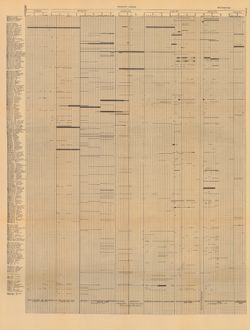
- Subject:
- Geographic Subject: Wayne County (Ind.), Topical Subject: Geology, Topical Subject: Paleontology, Geographic Subject: Tanners Creek (Ind. : Creek), Topical S...
- Creator:
- Cumings, E. R. (Edgar Roscoe), 1874-1967
- Publisher:
- Indiana. Department of Geology and Natural Resources
- Date Created:
- 1908
- Identifier:
- VAC3073-M-00692
- Genre:
- Graphs
- Geographic Location:
- Coordinates: W0845749 W0844849 N0395257 N0390333
- Related URL:
- Catalog URL: https://iucat.iu.edu/catalog/18298805
- Abstract:
- Title derived from captions. Chart showing stratigraphic measurements for paleontology samples collected around Tanner's Creek in Dearborn County and Ric...
- Call Number:
- G4091.C57 1908 .C86
- Caption:
- Imprint: [Indianapolis] : [Indiana Dept. of Geology and Natural Resources], [1908]
- Physical Description:
- Dimensions: 63 x 48 cm
- Alternate Identifier:
- Title Control Number: a18298805 and Alternate ID: 390726IP
- Persistent URL:
- https://purl.dlib.indiana.edu/iudl/images/VAC3073/VAC3073-M-00692
- Provenance:
- 32nd Annual Report (1907) / Indiana. Department of Geology and Natural Resources.
-
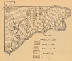
- Subject:
- Topical Subject: Loam soils, Geographic Subject: Switzerland County (Ind.), and Topical Subject: IGS Annual Reports
- Creator:
- Ward, L. C. (Louis Clinton), 1878-1931
- Publisher:
- Indiana. Department of Geology and Natural Resources
- Date Created:
- 1908
- Identifier:
- VAC3073-M-00370
- Genre:
- Thematic maps
- Geographic Location:
- Coordinates: W0851212 W0844704 N0385545 N0384115
- Related URL:
- Catalog URL: https://iucat.iu.edu/catalog/18349086
- Abstract:
- Detached from: A soil survey of Decatur, Jennings, Jefferson, Ripley, Dearborn, Ohio, and Switzerland counties, Indiana / L.C. Ward. In Indiana Dept. of Geol...
- Call Number:
- G4093.S9J3 1907 .S6
- Caption:
- Imprint: [Indianapolis] : [Indiana Department of Geology and Natural Resources], [1908]
- Physical Description:
- Scale: Scale not given. and Dimensions: on sheet 21 x 24 cm
- Alternate Identifier:
- Title Control Number: a18349086 and Alternate ID: 390726IP
- Persistent URL:
- https://purl.dlib.indiana.edu/iudl/images/VAC3073/VAC3073-M-00370
- Provenance:
- 32nd Annual Report (1907) / Indiana. Department of Geology and Natural Resources.
-
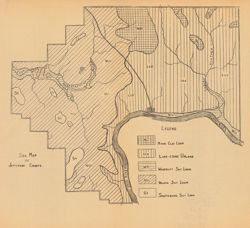
- Subject:
- Topical Subject: Loam soils, Geographic Subject: Jefferson County (Ind.), and Topical Subject: IGS Annual Reports
- Creator:
- Ward, L. C. (Louis Clinton), 1878-1931
- Publisher:
- Indiana. Department of Geology and Natural Resources
- Date Created:
- 1908
- Identifier:
- VAC3073-M-00101
- Genre:
- Geological maps
- Geographic Location:
- Coordinates: W0854104 W0851205 N0385500 N0383510
- Related URL:
- Catalog URL: https://iucat.iu.edu/catalog/18349087
- Abstract:
- Detached from: A soil survey of Decatur, Jennings, Jefferson, Ripley, Dearborn, Ohio, and Switzerland counties, Indiana / L.C. Ward. In Indiana Dept. of Geol...
- Call Number:
- G4093.J5J3 1908 .S6
- Caption:
- Imprint: [Indianapolis] : [Indiana Department of Geology and Natural Resources], [1908]
- Physical Description:
- Dimensions: on sheet 23 x 25 cm and Scale: Scale not given.
- Alternate Identifier:
- Alternate ID: 390726IP and Title Control Number: a18349087
- Persistent URL:
- https://purl.dlib.indiana.edu/iudl/images/VAC3073/VAC3073-M-00101
- Provenance:
- 32nd Annual Report (1907) / Indiana. Department of Geology and Natural Resources.
-
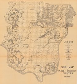
- Subject:
- Geographic Subject: Floyd County (Ind.), Geographic Subject: Harrison County (Ind.), and Topical Subject: Soils
- Creator:
- Ellis, R. W. (Robert W.)
- Publisher:
- Indiana. Department of Geology and Natural Resources
- Date Created:
- 1908
- Identifier:
- VAC3073-M-00741
- Genre:
- Thematic maps
- Geographic Location:
- Coordinates: W0861947 W0854538 N0382521 N0375728
- Related URL:
- Catalog URL: https://iucat.iu.edu/catalog/16096031
- Abstract:
- Detached from: A soil survey of Clark, Floyd, and Harrison counties / Robert W. Ellis. In Indiana Department of Geology and Natural Resources thirty-second a...
- Call Number:
- G4093.F5J3 1907 .E4
- Caption:
- Imprint: [Indianapolis] : [Indiana Department of Geology and Natural Resources], 1908
- Physical Description:
- Scale: Approximately 1:95,000 and Dimensions: 64 x 59 cm
- Alternate Identifier:
- Title Control Number: a16096031 and Alternate ID: 390726IP
- Persistent URL:
- https://purl.dlib.indiana.edu/iudl/images/VAC3073/VAC3073-M-00741
- Provenance:
- 32nd Annual Report (1907) / Indiana. Department of Geology and Natural Resources.
-
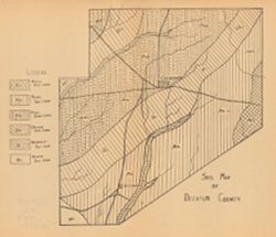
- Subject:
- Topical Subject: IGS Annual Reports, Geographic Subject: Decatur County (Ind.), and Topical Subject: Loam soils
- Publisher:
- Indiana. Department of Geology and Natural Resources
- Date Created:
- 1908
- Identifier:
- VAC3073-M-00136
- Genre:
- Geological maps
- Geographic Location:
- Coordinates: W0854116 W0851747 N0392712 N0390750
- Related URL:
- Catalog URL: https://iucat.iu.edu/catalog/18307561
- Abstract:
- Detached from: A soil survey of Decatur, Jennings, Jefferson, Ripley, Dearborn, Ohio, and Switzerland counties, Indiana / L.C. Ward. In Indiana Dept. of Geol...
- Call Number:
- G4093.D4J3 1907 .S6
- Caption:
- Imprint: [Indianapolis] : [Indiana Department of Geology and Natural Resources], [1908]
- Physical Description:
- Dimensions: on sheet 23 x 26 cm and Scale: Scale not given.
- Alternate Identifier:
- Title Control Number: a18307561 and Alternate ID: 390726IP
- Persistent URL:
- https://purl.dlib.indiana.edu/iudl/images/VAC3073/VAC3073-M-00136
- Provenance:
- 32nd Annual Report (1907) / Indiana. Department of Geology and Natural Resources.
-
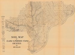
- Subject:
- Topical Subject: Soils, Geographic Subject: Clark County (Ind.), and Geographic Subject: Floyd County (Ind.)
- Creator:
- Ellis, R. W. (Robert W.)
- Publisher:
- Indiana. Department of Geology and Natural Resources
- Date Created:
- 1908
- Identifier:
- VAC3073-M-00249
- Genre:
- Thematic maps
- Geographic Location:
- Coordinates: W0855940 W0852455 N0383624 N0381601
- Related URL:
- Catalog URL: https://iucat.iu.edu/catalog/16152110
- Abstract:
- Detached from: A soil survey of Clark, Floyd, and Harrison counties / Robert W. Ellis. In Indiana Department of Geology and Natural Resources thirty-second a...
- Call Number:
- G4093.C4J3 1907 .E4
- Caption:
- Imprint: [Indianapolis] : [Indiana Department of Geology and Natural Resources], [1908]
- Physical Description:
- Dimensions: 49 x 64 cm and Scale: Approximately 1:90,000
- Alternate Identifier:
- Title Control Number: a16152110 and Alternate ID: 390726IP
- Persistent URL:
- https://purl.dlib.indiana.edu/iudl/images/VAC3073/VAC3073-M-00249
- Provenance:
- 32nd Annual Report (1907) / Indiana. Department of Geology and Natural Resources.
-
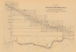
- Subject:
- Geographic Subject: Tanners Creek (Ind. : Creek), Topical Subject: Cleveland, Cinicinnati, Chicago, and St. Louis Railway Company, Topical Subject: Rivers, T...
- Creator:
- Cumings, E. R. (Edgar Roscoe), 1874-1967
- Publisher:
- Indiana. Department of Geology and Natural Resources
- Date Created:
- 1908
- Identifier:
- VAC3073-M-00855
- Genre:
- Thematic maps and Geological cross-sections
- Geographic Location:
- Coordinates: W0850300 W0845200 N0391300 N0390900
- Related URL:
- Catalog URL: https://iucat.iu.edu/catalog/18307543
- Abstract:
- 1 map and 1 section on 1 sheet. Relief shown by profile. Includes map, geological profile, geological time table, and correlation diagram. Detached from: ...
- Call Number:
- G4093.D3P3 1907 .C8
- Caption:
- Imprint: [Indianapolis] : [Indiana Dept. of Geology and Natural Resources], [1908]
- Physical Description:
- Scale: Approximately 1:49,000. Vertical scale approximately 1:950 and Dimensions: on sheet 31 x 44 cm
- Alternate Identifier:
- Title Control Number: a18307543 and Alternate ID: 390726IP
- Persistent URL:
- https://purl.dlib.indiana.edu/iudl/images/VAC3073/VAC3073-M-00855
- Provenance:
- 32nd Annual Report (1907) / Indiana. Department of Geology and Natural Resources.
-
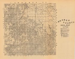
- Subject:
- Geographic Subject: Orange County (Ind.) and Topical Subject: Soils
- Creator:
- Indiana. Department of Geology and Natural Resources
- Publisher:
- Indiana. Department of Geology and Natural Resources
- Date Created:
- 1908
- Identifier:
- VAC3073-M-00221
- Genre:
- Thematic maps
- Geographic Location:
- Coordinates: W0864059 W0861827 N0384119 N0382346
- Related URL:
- Catalog URL: https://iucat.iu.edu/catalog/16095946
- Abstract:
- Detached from: A soil survey of Monroe, Brown, Lawrence, Martin, Orange, Washington and Jackson counties / by Chas. W. Shannon and L. C. Snider. In Indiana D...
- Call Number:
- G4093.O6J3 1907 .I53
- Caption:
- Imprint: [Indianapolis] : [Indiana Department of Geology and Natural Resources], [1908]
- Physical Description:
- Dimensions: 27 x 27 cm and Scale: Approximately 1:126,720
- Alternate Identifier:
- Title Control Number: a16095946 and Alternate ID: 390726IP
- Persistent URL:
- https://purl.dlib.indiana.edu/iudl/images/VAC3073/VAC3073-M-00221
- Provenance:
- 32nd Annual Report (1907) / Indiana. Department of Geology and Natural Resources.

- « Previous
- Next »
- 1
- 2
- 3