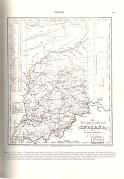
Variant title: Travellers pocket map of Indiana with its roads and distances. Relief shown by profile. Shows existing and proposed canals and railroads as we...
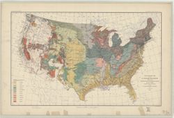
Compiled in 1970. Includes population key. Source data U.S. Dept. of the Interior - Geological Survey topographic maps. U.S. Dept of the Army - Corps of Engi...
Call Number:
G4091.C2 1973 .G4
Caption:
Imprint: [Reston, Va.] : U.S. Geological Survey, 1973
Geographic Subject: Knox County (Ind.), Geographic Subject: Wabash County (Ill.), Topical Subject: Vegetation mapping, and Geographic Subject: Gibson County ...
Creator:
Geological Survey (U.S.), Illinois State Geological Survey, and United States. Army Map Service
Publisher:
Geological Survey (U.S.)
Date Created:
1965
Identifier:
VAC3073-M-01388
Genre:
15 minute topographic maps, Quadrangle maps, and Topographic maps
Mapped, edited and published by the Geological Survey , Illinois area mapped in cooperation with State of Illinois Geological Survey. Filing title: Princeton...
Geographic Subject: Gibson County (Ind.), Geographic Subject: Knox County (Ind.), Geographic Subject: Wabash County (Ill.), and Topical Subject: Vegetation m...
Creator:
Geological Survey (U.S.), United States. Army Map Service, and Illinois State Geological Survey
Publisher:
Geological Survey (U.S.)
Date Created:
1965
Identifier:
VAC3073-M-01504
Genre:
Topographic maps, 15 minute topographic maps, and Quadrangle maps
Mapped, edited and published by the Geological Survey , Illinois area mapped in cooperation with State of Illinois Geological Survey. Filing title: Princeton...
Mapped, edited and published by the Geological Survey , Illinois area mapped in cooperation with State of Illinois Geological Survey. Filing title: Princeton...
Geographic Subject: Gibson County (Ind.), Topical Subject: Vegetation mapping, Geographic Subject: Wabash County (Ill.), and Geographic Subject: Knox County ...
Creator:
Geological Survey (U.S.), United States. Army Map Service, and Illinois State Geological Survey
Publisher:
Geological Survey (U.S.)
Date Created:
1964
Identifier:
VAC3073-M-01387
Genre:
Quadrangle maps, 15 minute topographic maps, and Topographic maps
Mapped, edited and published by the Geological Survey , Illinois area mapped in cooperation with State of Illinois Geological Survey. Filing title: Princeton...
Geographic Subject: Knox County (Ind.), Geographic Subject: Gibson County (Ind.), Geographic Subject: Wabash County (Ill.), and Topical Subject: Vegetation m...
Creator:
Illinois State Geological Survey, Geological Survey (U.S.), and United States. Army Map Service
Publisher:
Geological Survey (U.S.)
Date Created:
1964
Identifier:
VAC3073-M-01386
Genre:
15 minute topographic maps, Topographic maps, and Quadrangle maps
Mapped, edited and published by the Geological Survey , Illinois area mapped in cooperation with State of Illinois Geological Survey. Filing title: Princeton...

![Princeton quadrangle, Indiana-Illinois : 15 minute series (topographic) [1965 reprint with vegetation]](https://iiif.uits.iu.edu/iiif/2/sx61fr138%2Ffiles%2F603798b1-0337-482a-9bb7-934a41ad4b2b/full/250,/0/default.jpg)
![Princeton quadrangle, Indiana-Illinois : 15 minute series (topographic) [1965 reprint with vegetation]](https://iiif.uits.iu.edu/iiif/2/7m01cp47j%2Ffiles%2Fdc826735-24b7-4c3f-9d9b-87ad67efd7e8/full/250,/0/default.jpg)
![Princeton quadrangle, Indiana-Illinois : 15 minute series (topographic) [1965 printing without vegetation]](https://iiif.uits.iu.edu/iiif/2/70796d47m%2Ffiles%2Fedc5c6d4-9f41-4b7c-9447-a370bfe906e0/full/250,/0/default.jpg)
![Princeton quadrangle, Indiana-Illinois : 15 minute series (topographic) [1964 printing with vegetation]](https://iiif.uits.iu.edu/iiif/2/m900px89p%2Ffiles%2Fe957c77d-db8c-42d6-aef0-05abd0d3301b/full/250,/0/default.jpg)
![Princeton quadrangle, Indiana-Illinois : 15 minute series (topographic) [1964 printing with vegetation]](https://iiif.uits.iu.edu/iiif/2/ng452m35w%2Ffiles%2F49af6c65-fc22-44ea-8486-c7923f5afb8b/full/250,/0/default.jpg)
