
Search Constraints
You searched for:
Publisher
Indiana. Department of Geology and Natural Resources
Remove constraint Publisher: Indiana. Department of Geology and Natural Resources
Subject
Topical Subject: Soils
Remove constraint Subject: Topical Subject: Soils
« Previous |
1 - 10 of 42
|
Next »
Search Results
-
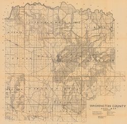
- Subject:
- Geographic Subject: Washington County (Ind.) and Topical Subject: Soils
- Creator:
- Indiana. Department of Geology and Natural Resources
- Publisher:
- Indiana. Department of Geology and Natural Resources
- Date Created:
- 1908
- Identifier:
- VAC3073-M-00603
- Genre:
- Thematic maps
- Geographic Location:
- Coordinates: W0861836 W0855051 N0384700 N0382504
- Related URL:
- Catalog URL: https://iucat.iu.edu/catalog/16096233
- Abstract:
- Shows railroads, dirt roads, improved roads, school houses, and churches. Detached from: Soil survey of Monroe, Brown, Lawrence, Martin, Orange, Washingto...
- Call Number:
- G4093.W5J3 1907 .I53
- Caption:
- Imprint: [Indianapolis] : [Indiana Department of Geology and Natural Resources], [1908]
- Physical Description:
- Scale: Approximately 1:63,360 and Dimensions: 67 x 68 cm
- Alternate Identifier:
- Title Control Number: a16096233 and Alternate ID: 390726IP
- Persistent URL:
- https://purl.dlib.indiana.edu/iudl/images/VAC3073/VAC3073-M-00603
- Provenance:
- 32nd Annual Report (1907) / Indiana. Department of Geology and Natural Resources.
-
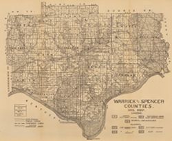
- Subject:
- Geographic Subject: Spencer County (Ind.), Geographic Subject: Warrick County (Ind.), and Topical Subject: Soils
- Creator:
- Shannon, C. W. (Charles William), 1879-1934
- Publisher:
- Indiana. Department of Geology and Natural Resources
- Date Created:
- 1910
- Identifier:
- VAC3073-M-00654
- Genre:
- Thematic maps
- Geographic Location:
- Coordinates: W0872823 W0864559 N0381446 N0374653
- Related URL:
- Catalog URL: https://iucat.iu.edu/catalog/16123910
- Abstract:
- Shows public roads and railroads. Detached from: A soil survey of Vanderburgh, Gibson, and Pike, and parts of Warrick and Spencer counties / Chas. W. Shan...
- Call Number:
- G4093.S5J3 1909 .S5
- Caption:
- Imprint: [Indianapolis] : [Indiana Department of Geology and Natural Resources], [1910]
- Physical Description:
- Dimensions: 44 x 52 cm and Scale: Approximately 1:126,720
- Alternate Identifier:
- Title Control Number: a16123910 and Alternate ID: 390726IP
- Persistent URL:
- https://purl.dlib.indiana.edu/iudl/images/VAC3073/VAC3073-M-00654
- Provenance:
- 34th Annual Report (1909) / Indiana. Department of Geology and Natural Resources.
-
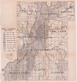
- Subject:
- Geographic Subject: Vigo County (Ind.), Topical Subject: Soils, Topical Subject: Geology, and Topical Subject: Mines and mineral resources
- Creator:
- Shannon, M. E., Shannon, C. W. (Charles William), 1879-1934, and United States. Bureau of Soils
- Publisher:
- Indiana. Department of Geology and Natural Resources
- Date Created:
- 1912
- Identifier:
- VAC3073-M-01092
- Genre:
- Thematic maps
- Geographic Location:
- Coordinates: W0873635 W0871156 N0393629 N0391532
- Related URL:
- Catalog URL: https://iucat.iu.edu/catalog/16131306
- Abstract:
- Shows dirt roads and improved public roads, railroads, school houses, cemeteries, and churches. Detached from: Soil survey of Clay, Knox, Sullivan, and Vi...
- Call Number:
- G4093.V5J3 1911 .S5
- Caption:
- Imprint: [Indianapolis] : [Department of Geology and Natural Resources, Indiana], [1912] [Indianapolis] : [Wm. B. Burford], [1912]
- Physical Description:
- Dimensions: 64 x 59 cm and Scale: Approximately 1:63,360
- Alternate Identifier:
- Title Control Number: a16131306 and Alternate ID: 390726IP
- Persistent URL:
- https://purl.dlib.indiana.edu/iudl/images/VAC3073/VAC3073-M-01092
- Provenance:
- 36th Annual Report (1911) / Indiana. Department of Geology and Natural Resources.
-
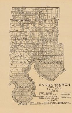
- Subject:
- Topical Subject: Soils and Geographic Subject: Vanderburgh County (Ind.)
- Creator:
- Shannon, C. W. (Charles William), 1879-1934
- Publisher:
- Indiana. Department of Geology and Natural Resources
- Date Created:
- 1910
- Identifier:
- VAC3073-M-00292
- Genre:
- Thematic maps
- Geographic Location:
- Coordinates: W0874202 W0872657 N0381006 N0374932
- Related URL:
- Catalog URL: https://iucat.iu.edu/catalog/16123565
- Abstract:
- Shows railroads and public roads. Detached from: A soil survey of Vanderburgh, Gibson, and Pike, and parts of Warrick and Spencer counties / Chas. W. Shan...
- Call Number:
- G4093.V3J3 1909 .S5
- Caption:
- Imprint: [Indianapolis] : [Indiana Department of Geology and Natural Resources], [1910]
- Physical Description:
- Dimensions: 37 x 24 cm and Scale: Approximately 1:126,720
- Alternate Identifier:
- Alternate ID: 390726IP and Title Control Number: a16123565
- Persistent URL:
- https://purl.dlib.indiana.edu/iudl/images/VAC3073/VAC3073-M-00292
- Provenance:
- 34th Annual Report (1909) / Indiana. Department of Geology and Natural Resources.
-
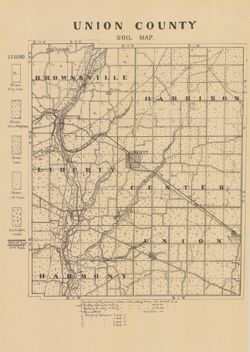
- Subject:
- Topical Subject: Soils and Geographic Subject: Union County (Ind.)
- Creator:
- Indiana. Department of Geology and Natural Resources
- Publisher:
- Indiana. Department of Geology and Natural Resources
- Date Created:
- 1910
- Identifier:
- VAC3073-M-00859
- Genre:
- Thematic maps
- Geographic Location:
- Coordinates: W0850210 W0844851 N0394345 N0393119
- Related URL:
- Catalog URL: https://iucat.iu.edu/catalog/16124317
- Abstract:
- Shows railroads, dirt roads, and gravel roads. Includes notes on general topography. Detached from: A soil survey of Randolph, Wayne, Henry, Rush, Fayette...
- Call Number:
- G4093.U5J3 1909 .I53
- Caption:
- Imprint: [Indianapolis] : [Indiana Department of Geology and Natural Resources], [1910]
- Physical Description:
- Dimensions: 25 x 21 cm and Scale: Approximately 1:95,000
- Alternate Identifier:
- Title Control Number: a16124317 and Alternate ID: 390726IP
- Persistent URL:
- https://purl.dlib.indiana.edu/iudl/images/VAC3073/VAC3073-M-00859
- Provenance:
- 34th Annual Report (1909) / Indiana. Department of Geology and Natural Resources.
-
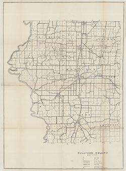
- Subject:
- Topical Subject: Soils, Geographic Subject: Sullivan County (Ind.), Topical Subject: IGS Annual Reports, and Topical Subject: Soil surveys
- Creator:
- Shannon, C. W. (Charles William), 1879-1934 and Shannon, M. E.
- Publisher:
- Indiana. Department of Geology and Natural Resources
- Date Created:
- 1912
- Identifier:
- VAC3073-M-01483
- Genre:
- Thematic maps
- Geographic Location:
- Coordinates: W0873845 W0871422 N0391540 N0385413
- Related URL:
- Catalog URL: https://iucat.iu.edu/catalog/18307850
- Abstract:
- Shows soil types, earth and improved public roads, railroads, schools, cemeteries, churches, and coal mines. Detached from: Soil survey of Clay, Knox, Sul...
- Call Number:
- G4093.S8J3 1911 .S5
- Caption:
- Imprint: [Indianapolis] : [Department of Geology and Natural Resources, Indiana], [1912]
- Physical Description:
- Scale: Approximately 1:63,360 and Dimensions: on sheet 64 x 59 cm
- Alternate Identifier:
- Alternate ID: 390726IP and Title Control Number: a18307850
- Persistent URL:
- https://purl.dlib.indiana.edu/iudl/images/VAC3073/VAC3073-M-01483
- Provenance:
- 36th Annual Report (1911) / Indiana. Department of Geology and Natural Resources.
-
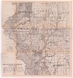
- Subject:
- Geographic Subject: Sullivan County (Ind.) and Topical Subject: Soils
- Creator:
- Shannon, M. E. and Shannon, C. W. (Charles William), 1879-1934
- Publisher:
- Indiana. Department of Geology and Natural Resources
- Date Created:
- 1912
- Identifier:
- VAC3073-M-01095
- Genre:
- Thematic maps
- Geographic Location:
- Coordinates: W0873933 W0871425 N0391534 N0385405
- Related URL:
- Catalog URL: https://iucat.iu.edu/catalog/16137467
- Abstract:
- Shows dirt roads and improved public roads, railroads, schools, cemeteries, churches, and coal mines. Detached from: Soil survey of Clay, Knox, Sullivan, ...
- Call Number:
- G4093.S8J3 1911 .S5
- Caption:
- Imprint: [Indianapolis] : [Department of Geology and Natural Resources, Indiana], [1912] [Indianapolis] : [Wm. B. Burford], [1912]
- Physical Description:
- Scale: Approximately 1:63,360 and Dimensions: 64 x 59 cm
- Alternate Identifier:
- Title Control Number: a16137467 and Alternate ID: 390726IP
- Persistent URL:
- https://purl.dlib.indiana.edu/iudl/images/VAC3073/VAC3073-M-01095
- Provenance:
- 36th Annual Report (1911) / Indiana. Department of Geology and Natural Resources.
-
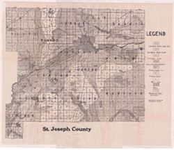
- Subject:
- Geographic Subject: Saint Joseph County (Ind.) and Topical Subject: Soils
- Creator:
- Indiana. Department of Geology and Natural Resources
- Publisher:
- Indiana. Department of Geology and Natural Resources
- Date Created:
- 1912
- Identifier:
- VAC3073-M-01087
- Genre:
- Thematic maps
- Geographic Location:
- Coordinates: W0863136 W0860333 N0414538 N0412558
- Related URL:
- Catalog URL: https://iucat.iu.edu/catalog/16137081
- Abstract:
- Shows dirt roads, improved roads, and railroads. Detached from: Soil survey of St. Joseph County / E.J. Quinn. In Thirty-sixth annual report of Department...
- Call Number:
- G4093.S2J3 1911 .I53
- Caption:
- Imprint: [Indianapolis] : [Department of Geology and Natural Resources], [1912] and Imprint: [Indianapolis] : [Wm. B. Burford], [1912]
- Physical Description:
- Dimensions: 43 x 45 cm, on sheet 46 x 56 cm and Scale: Approximately 1:90,000
- Alternate Identifier:
- Title Control Number: a16137081 and Alternate ID: 390726IP
- Persistent URL:
- https://purl.dlib.indiana.edu/iudl/images/VAC3073/VAC3073-M-01087
- Provenance:
- 36th Annual Report (1911) / Indiana. Department of Geology and Natural Resources.
-
- Subject:
- Topical Subject: Soils and Geographic Subject: Marion County (Ind.)
- Creator:
- Geib, W. J. (Warren Jacob), 1880- and Schroeder, Frank C.
- Publisher:
- Indiana. Department of Geology and Natural Resources
- Date Created:
- 1912
- Identifier:
- VAC3073-M-01090
- Genre:
- Thematic maps
- Geographic Location:
- Coordinates: W0861941 W0855614 N0395538 N0393755
- Related URL:
- Catalog URL: https://iucat.iu.edu/catalog/16151623
- Abstract:
- Detached from: Soil survey of Marion County, Indiana / W.J. Geib and Frank C. Schroeder. In Thirty-sixth annual report of Department of Geology and Natural R...
- Call Number:
- G4093.M3J3 1911 .G4
- Caption:
- Imprint: [Indianapolis] : [Wm. B. Burford], [1912] and Imprint: [Indianapolis] : [Department of Geology and Natural Resources], [1912]
- Physical Description:
- Scale: Approximately 1:63,360 and Dimensions: 53 x 53 cm
- Alternate Identifier:
- Alternate ID: 390726IP and Title Control Number: a16151623
- Persistent URL:
- https://purl.dlib.indiana.edu/iudl/images/VAC3073/VAC3073-M-01090
- Provenance:
- 36th Annual Report (1911) / Indiana. Department of Geology and Natural Resources.
-
- Subject:
- Geographic Subject: Wells County (Ind.), Topical Subject: IGS Annual Reports, and Topical Subject: Soils
- Creator:
- United States. Bureau of Soils, Tharp, W. E. (William Edgar), and Wiley, W. E. (William Emmett), 1894-1967
- Publisher:
- Indiana. Department of Geology and Natural Resources
- Date Created:
- 1916
- Identifier:
- VAC3073-M-01537
- Genre:
- Thematic maps
- Geographic Location:
- Coordinates: W0852656 W0850406 N0405504 N0403400
- Related URL:
- Catalog URL: https://iucat.iu.edu/catalog/16138560
- Abstract:
- "Field Operations, Bureau of Soils, 1915." Detached from: Soil survey of Wells County / W. E. Tharp and W. E. Wiley. In Fortieth annual report o...
- Call Number:
- G4093.W7J3 1915 .T49
- Caption:
- Imprint: [Fort Wayne]: [Fort Wayne Printing Company], [1916] and Imprint: [Indianapolis] : State of Indiana, Department of Geology, [1916]
- Physical Description:
- Dimensions: 58 x 48 cm and Scale: 1:63,360. 1 in. = 1 mile
- Alternate Identifier:
- Title Control Number: a16138560 and Alternate ID: 390726IP
- Persistent URL:
- https://purl.dlib.indiana.edu/iudl/images/VAC3073/VAC3073-M-01537
- Provenance:
- 40th Annual Report (1915) / Indiana. Department of Geology and Natural Resources.
