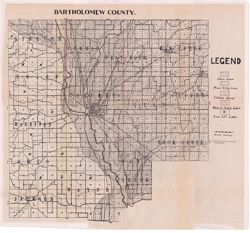
Shows roads and railroads. Detached from: Soil survey of Bartholomew County / E.J. Quinn. In Thirty-sixth annual report of Department of Geology and Natur...
Call Number:
G4093.B3J3 1911 .I53
Caption:
Imprint: [Indianapolis] : [Department of Geology and Natural Resources], [1912] and Imprint: [Indianapolis] : [Wm. B. Burford], [1912]
Physical Description:
Dimensions: 40 x 41 cm, on sheet 44 x 49 cm and Scale: Approximately 1:85,000
Alternate Identifier:
Alternate ID: 390726IP and Title Control Number: a16136919
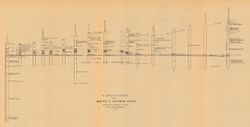
Includes 17 stratigraphic columns and correlation lines. Detached from: The stratigraphy and paleontology of the Cincinnati series of Indiana / E.R. Cumin...
Call Number:
G4091.C57 1908 .C86
Caption:
Imprint: [Indianapolis] : [Wm. B. Burford], [1908] and Imprint: [Indianapolis] : [Indiana Department of Geology and Natural Resources], [1908]
Physical Description:
Dimensions: on sheet 32 x 60 cm and Scale: Scale not given.
Alternate Identifier:
Title Control Number: a18298808 and Alternate ID: 390726IP
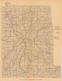
Shows roads, improved roads, rural routes, rail roads, and road metal quarries. Alternate title: Illustrating the roads of Monroe County. At head of alternat...
Call Number:
G4093.M7P2 1905 .R6
Caption:
Imprint: Indianapolis : 1906
Physical Description:
Scale: Approximately 1:130,000 and Dimensions: 36 x 27 cm
Alternate Identifier:
Alternate ID: 390726IP and Title Control Number: a18298783
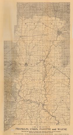
Geographic Subject: Union County (Ind.), Geographic Subject: Franklin County (Ind.), Topical Subject: IGS Annual Reports, Geographic Subject: Indiana, Topica...
Publisher:
Indiana. Department of Geology and Natural Resources
Date Created:
1908
Identifier:
VAC3073-M-00272
Genre:
Geological maps
Related URL:
Catalog URL: https://iucat.iu.edu/catalog/9676901
Abstract:
Showing the Location of sections and collecting localities and the boundary between the Ordovician and Silurian Systems. Detached from: The stratigraphy a...
Call Number:
QE109 .A2 1907 map p605
Caption:
Imprint: Indianapolis : 1908
Physical Description:
Dimensions: 67 x 37 cm and Scale: Approximately 1:126,720. 2 miles = 1 inch
"Boundary after Foerste." Detached from: The stratigraphy and paleontology of the Cincinnati series of Indiana / E.R. Cumings. In Indiana Dept. ...
Call Number:
G4091.C57 1908 .M3
Caption:
Imprint: [Indianapolis] : [Indiana Dept. of Geology and Natural Resources], [1908]
Physical Description:
Dimensions: on sheet 60 x 51 cm and Scale: Approximately 1:126,720. 2 miles to the 1 inch
Alternate Identifier:
Title Control Number: a18307520 and Alternate ID: 390726IP
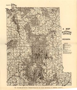
Topical Subject: IGS Annual Reports, Topical Subject: Mines and mineral resources, Topical Subject: Road materials, and Geographic Subject: Monroe County (Ind.)
Publisher:
Indiana. Department of Geology and Natural Resources
Alternate title: Illustrating the distribution of road materials in Monroe County. At head of alternate title: Fig. 53B. Shows roads, limestone, gravel, sand...
Call Number:
G4093.M7H5 1905 .M3
Caption:
Imprint: [Indianapolis] : [Indiana Dept. of Geology and Natural Resources], [1906]
Physical Description:
Scale: Approximately 1:171,000 and Dimensions: 26 x 22 cm
Alternate Identifier:
Alternate ID: 390726IP and Title Control Number: a18299087