
Search Constraints
You searched for:
Date Created
1932
Remove constraint Date Created: 1932
Collections
Russian Military Topographic Map Collection
Remove constraint Collections: Russian Military Topographic Map Collection
Subject
Topical Subject: Maps
Remove constraint Subject: Topical Subject: Maps
Search Results
-
- Description:
- 1931
- Subject:
- Topical Subject: Maps, Geographic Subject: Manzheliya, and Topical Subject: Soviet Union
- Publisher:
- Управление военных топографов
- Language:
- Russian
- Date Created:
- 1932
- Identifier:
- VAC9619-001072
- Genre:
- Topographic Maps and Military Maps
- Geographic Location:
- Coordinates: 49, 32.75, 49.1667, 33
- Related URL:
- DataCORE Dataset Download: https://datacore.iu.edu/concern/data_sets/t435gd77m
- Abstract:
- Modern area represented: Manzheliya, Poltava oblast,, Ukraine
- Call Number:
- G7000 s50 .S68 М-36-104-А
- Caption:
- Не подлежит оглашению
- City:
- С. Манжелия (Manzheliya)
- Copyright Holder:
- No Copyright - United States
- Country:
- СССР (USSR)
- State/Province:
- Украинская ССР (Ukrainian Soviet Socialist Republic) and Харьковская область (Kharkiv oblast)
- Physical Description:
- Scale: 1:50,000
- Persistent URL:
- http://purl.dlib.indiana.edu/iudl/images/VAC9619/VAC9619-001072
- Provenance:
- DMA Topographic Center, Army Map Service Library, Library of Congress Geography & Map Division
-
- Description:
- 1929
- Subject:
- Geographic Subject: Zhornokl'ovy, Topical Subject: Maps, and Topical Subject: Soviet Union
- Publisher:
- Управление военных топографов
- Language:
- Russian
- Date Created:
- 1932
- Identifier:
- VAC9619-000991
- Genre:
- Military Maps and Topographic Maps
- Geographic Location:
- Coordinates: 49.833, 31.75, 50, 32
- Related URL:
- DataCORE Dataset Download: https://datacore.iu.edu/concern/data_sets/tt44pn61j
- Abstract:
- Modern area represented: Жорнокльови (Zhornokl'ovy), Cherkasy oblast, Ukraine
- Call Number:
- G7000 s50 .S68 sheet M-36-76-B
- Caption:
- Captured map, Рассекречено, and Не подлежит оглашению (crossed out)
- City:
- Жорноклевы (Zhornoklevy)
- Copyright Holder:
- No Copyright - United States
- Country:
- СССР (USSR)
- State/Province:
- Украинская ССР (Ukrainian Soviet Socialist Republic)
- Physical Description:
- Scale: 1:50,000
- Persistent URL:
- http://purl.dlib.indiana.edu/iudl/images/VAC9619/VAC9619-000991
- Provenance:
- DMA Topographic Center, Army Map Service Library, OMAHA, Library of Congress Geography & Map Division
-
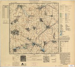
- Description:
- 1923
- Subject:
- Geographic Subject: Rokytne, Topical Subject: Soviet Union, and Topical Subject: Maps
- Publisher:
- Управление военных топографов
- Language:
- Russian
- Date Created:
- 1932
- Identifier:
- VAC9619-000985
- Genre:
- Topographic Maps and Military Maps
- Geographic Location:
- Coordinates: 49.667, 30.25, 49.833, 30.5
- Related URL:
- DataCORE Dataset Download: https://datacore.iu.edu/concern/data_sets/f4752h48r
- Abstract:
- Modern area represented: Рокитне (Rokytne), Kyiv oblast, Ukraine
- Call Number:
- G7000 s50 .S68 sheet M-36-73-D
- Caption:
- Не подлежит оглашению
- City:
- Рокитно (Rokitno)
- Copyright Holder:
- No Copyright - United States
- Country:
- СССР (USSR)
- State/Province:
- Украинская ССР (Ukrainian Soviet Socialist Republic) and Киевская область (Kyiv oblast)
- Physical Description:
- Scale: 1:50,000
- Persistent URL:
- http://purl.dlib.indiana.edu/iudl/images/VAC9619/VAC9619-000985
- Provenance:
- DMA Topographic Center, Army Map Service Library, OMAHA, Library of Congress Geography & Map Division
-
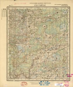
- Description:
- 1924
- Subject:
- Topical Subject: Soviet Union, Geographic Subject: Остер (Oster), and Topical Subject: Maps
- Publisher:
- Управление военных топографов
- Language:
- Russian
- Date Created:
- 1932
- Identifier:
- VAC9619-000942
- Genre:
- Topographic Maps and Military Maps
- Geographic Location:
- Coordinates: 50.833, 30.75, 51, 31
- Related URL:
- DataCORE Dataset Download: https://datacore.iu.edu/concern/data_sets/qr46r145t
- Abstract:
- Modern area represented: Остер (Oster), Chernihiv oblast, Ukraine
- Call Number:
- G7000 s50 .S68 sheet M-36-38-B
- Caption:
- Не подлежит оглашению
- City:
- Остер (Oster)
- Copyright Holder:
- No Copyright - United States
- Country:
- СССР (USSR)
- State/Province:
- Киевская область (Kyiv oblast) and Украинская ССР (Ukrainian Soviet Socialist Republic)
- Physical Description:
- Scale: 1:50,000
- Persistent URL:
- http://purl.dlib.indiana.edu/iudl/images/VAC9619/VAC9619-000942
- Provenance:
- DMA Topographic Center, Army Map Service Library, OMAHA, Library of Congress Geography & Map Division
-
- Description:
- 1908
- Subject:
- Topical Subject: Soviet Union, Geographic Subject: Самгородок (Samhorodok), and Topical Subject: Maps
- Publisher:
- Управление военных топографов
- Language:
- Russian
- Date Created:
- 1932
- Identifier:
- VAC9619-000875
- Genre:
- Military Maps and Topographic Maps
- Geographic Location:
- Coordinates: 49.5, 29.5, 49.6667, 29.75
- Related URL:
- DataCORE Dataset Download: https://datacore.iu.edu/concern/data_sets/5x21tg02z
- Abstract:
- Modern area represented: Самгородок (Samhorodok), Kyiv Oblast, Ukraine
- Call Number:
- G7000 s50 .S68 sheet M-35-96-A
- Caption:
- Не подлежит оглашению
- City:
- Самгородок (Samgorodok)
- Copyright Holder:
- No Copyright - United States
- Country:
- СССР (USSR)
- State/Province:
- Киевская область (Kyiv oblast) and Украинская ССР (Ukrainian Soviet Socialist Republic)
- Physical Description:
- Scale: 1:50,000
- Persistent URL:
- http://purl.dlib.indiana.edu/iudl/images/VAC9619/VAC9619-000875
- Provenance:
- DMA Topographic Center, Army Map Service Library, OMAHA, Library of Congress Geography & Map Division
-
- Description:
- 1908
- Subject:
- Topical Subject: Maps, Topical Subject: Soviet Union, and Geographic Subject: Ulaniv
- Publisher:
- Управление военных топографов
- Language:
- Russian
- Date Created:
- 1932
- Identifier:
- VAC9619-000841
- Genre:
- Topographic Maps and Military Maps
- Geographic Location:
- Coordinates: 49.667, 28, 49.833, 28.25
- Related URL:
- DataCORE Dataset Download: https://datacore.iu.edu/concern/data_sets/xp68kh02m
- Abstract:
- Modern area represented: Ulaniv, Vinnytsia oblast, Ukraine
- Call Number:
- G7000 s50 .S68 sheet M-35-81-С
- Caption:
- Не подлежит оглашению
- City:
- Уланов (Ulanov)
- Copyright Holder:
- No Copyright - United States
- Country:
- СССР (USSR)
- State/Province:
- Украинская ССР (Ukrainian Soviet Socialist Republic) and Винницкая область (Vinnytsia oblast)
- Physical Description:
- Scale: 1:50,000
- Persistent URL:
- http://purl.dlib.indiana.edu/iudl/images/VAC9619/VAC9619-000841
- Provenance:
- CIA Map Branch -- Received
-
- Description:
- 1925
- Subject:
- Geographic Subject: Polatsk, Topical Subject: Maps, and Topical Subject: Soviet Union
- Publisher:
- Управление военных топографов
- Language:
- Russian
- Date Created:
- 1932
- Identifier:
- VAC9619-000470
- Genre:
- Military Maps and Topographic Maps
- Geographic Location:
- Coordinates: 55.333, 28.75, 55.5, 29
- Related URL:
- DataCORE Dataset Download: https://datacore.iu.edu/concern/data_sets/2801ph05p
- Abstract:
- Modern area represented: Polatsk, Vitebsk oblast, Belarus
- Call Number:
- G7000 s50 .S68 sheet N-35-22-D
- Caption:
- Не подлежит оглашению
- City:
- Полоцк (Polotsk)
- Copyright Holder:
- No Copyright - United States
- Country:
- СССР (USSR)
- State/Province:
- Белорусская ССР (Byelorussian Soviet Socialist Republic)
- Physical Description:
- Scale: 1:50,000
- Persistent URL:
- http://purl.dlib.indiana.edu/iudl/images/VAC9619/VAC9619-000470
- Provenance:
- M. I. Map Library, Library of Congress Geography & Map Division, GS, RA, G000-30, Atlasblatt
-
- Subject:
- Geographic Subject: Polatsk, Topical Subject: Maps, and Topical Subject: Soviet Union
- Publisher:
- Управление военных топографов
- Language:
- Russian
- Date Created:
- 1932
- Identifier:
- VAC9619-000468
- Genre:
- Topographic Maps and Military Maps
- Geographic Location:
- Coordinates: 55.5, 28.75, 55.6667, 29
- Related URL:
- DataCORE Dataset Download: https://datacore.iu.edu/concern/data_sets/r207tq213
- Abstract:
- Modern area represented: Polatsk, Vitebsk oblast, Belarus
- Call Number:
- G7000 s50 .S68 sheet N-35-22-B
- Caption:
- Не подлежит оглашению
- City:
- Громенки (Gromenki)
- Copyright Holder:
- No Copyright - United States
- Country:
- СССР (USSR)
- State/Province:
- Белорусская ССР (Byelorussian Soviet Socialist Republic)
- Physical Description:
- Scale: 1:50,000
- Persistent URL:
- http://purl.dlib.indiana.edu/iudl/images/VAC9619/VAC9619-000468
- Provenance:
- M. I. Map Library, Library of Congress Geography & Map Division, GS, RA, G000-30
-
- Subject:
- Geographic Subject: Zarasai, Topical Subject: Maps, and Topical Subject: Soviet Union
- Publisher:
- Управление военных топографов
- Language:
- Russian
- Date Created:
- 1932
- Identifier:
- VAC9619-000402
- Genre:
- Topographic Maps and Military Maps
- Geographic Location:
- Coordinates: 55.667, 26.25, 55.833, 26.5
- Related URL:
- DataCORE Dataset Download: https://datacore.iu.edu/concern/data_sets/8p58pd59w
- Abstract:
- Modern area represented: Zarasai, Lithuania
- Call Number:
- G7000 s50 .S68 sheet N-35-5-D
- City:
- Ново-Александровск (Novo-Aleksandrovsk)
- Copyright Holder:
- No Copyright - United States
- Country:
- Польша (Poland), Латвия (Latvia), and Литва (Lithuania)
- Physical Description:
- Scale: 1:50,000
- Persistent URL:
- http://purl.dlib.indiana.edu/iudl/images/VAC9619/VAC9619-000402
- Provenance:
- Army Map Service Library, OMAHA, Library of Congress Geography & Map Division
-
- Description:
- 1923
- Subject:
- Topical Subject: Soviet Union, Topical Subject: Maps, and Geographic Subject: Muzykivka
- Publisher:
- Управление военных топографов
- Language:
- Russian
- Date Created:
- 1932
- Identifier:
- VAC9619-000112
- Genre:
- Topographic Maps and Military Maps
- Geographic Location:
- Coordinates: 46.6667, 32.5, 46.8333, 32.75
- Related URL:
- DataCORE Dataset Download: https://datacore.iu.edu/concern/data_sets/79407x83t
- Abstract:
- Modern area represented: Muzykivka, Kherson oblast, Ukraine
- Call Number:
- G7000 s50 .S68 sheet L-36-42-C
- Caption:
- Не подлежит оглашению,Секретно
- City:
- Музыковка (Muzykovka)
- Copyright Holder:
- No Copyright - United States
- Country:
- СССР (USSR)
- State/Province:
- Украинская ССР (Ukrainian Soviet Socialist Republic)
- Physical Description:
- Scale: 1:50,000
- Persistent URL:
- http://purl.dlib.indiana.edu/iudl/images/VAC9619/VAC9619-000112
- Provenance:
- DMA Topographic Center, Army Map Service Library, OMAHA, Library of Congress Geography & Map Division
