
Search Constraints
You searched for:
Publisher
Indiana. Department of Geology and Natural Resources
Remove constraint Publisher: Indiana. Department of Geology and Natural Resources
Subject
Geographic Subject: Greene County (Ind.)
Remove constraint Subject: Geographic Subject: Greene County (Ind.)
1 - 6 of 6
Search Results
-
- Subject:
- Geographic Subject: Monroe County (Ind.), Geographic Subject: Greene County (Ind.), Geographic Subject: Indiana, Geographic Subject: Owen County (Ind.), and ...
- Publisher:
- Indiana. Department of Geology and Natural Resources
- Date Created:
- 1915
- Identifier:
- VAC3073-M-01188
- Genre:
- Quadrangle maps, Topographic maps, and Geological maps
- Geographic Location:
- Coordinates: W0864500 W0863000 N0391500 N0390000
- Related URL:
- Catalog URL: https://iucat.iu.edu/catalog/16190483
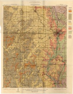
- Abstract:
- Relief shown by contours and spot heights. Contour interval 20 feet. Shows limestone locations in a portion of Monroe County and small portions of Owen and G...
- Call Number:
- G4093.M7C5 1914 .I6
- Caption:
- Imprint: [Indianapolis] : Indiana Dept. of Geology [and Natural Resources], [1915] and Imprint: [Indianapolis] : [Wm. B. Burford], [1915]
- Physical Description:
- Scale: 1:62,500 and Dimensions: 45 x 35 cm
- Alternate Identifier:
- Title Control Number: a16190483 and Alternate ID: 390726IP
- Persistent URL:
- https://purl.dlib.indiana.edu/iudl/images/VAC3073/VAC3073-M-01188
- Provenance:
- 39th Annual Report (1914) / Indiana. Department of Geology and Natural Resources.
-
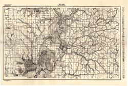
- Subject:
- Geographic Subject: Greene County (Ind.) and Topical Subject: Soils
- Creator:
- Tharp, W. E. (William Edgar)
- Publisher:
- Indiana. Department of Geology and Natural Resources
- Date Created:
- 1912
- Identifier:
- VAC3073-M-01159
- Genre:
- Thematic maps
- Geographic Location:
- Coordinates: W0871427 W0864055 N0391018 N0385408
- Related URL:
- Catalog URL: https://iucat.iu.edu/catalog/16151513
- Abstract:
- Detached from: Soil survey of Greene County (1901) / by W. E. Tharp and Charles J. Mann, of the U. S. Bureau of Soils. In Thirty-sixth annual report of Depar...
- Call Number:
- G4093.G7J3 1906 .T5
- Caption:
- Imprint: [Indianapolis] : State of Indiana, Department of Geology, [1912] [Indianapolis] : [Wm. B. Burford], [1912]
- Physical Description:
- Dimensions: 35 x 52 cm and Scale: 1:80,000
- Alternate Identifier:
- Title Control Number: a16151513 and Alternate ID: 390726IP
- Persistent URL:
- https://purl.dlib.indiana.edu/iudl/images/VAC3073/VAC3073-M-01159
- Provenance:
- 36th Annual Report (1911) / Indiana. Department of Geology and Natural Resources.
-
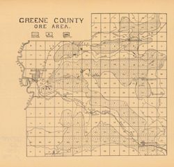
- Subject:
- Geographic Subject: Greene County (Ind.), Topical Subject: Iron ores, and Topical Subject: IGS Annual Reports
- Publisher:
- Indiana. Department of Geology and Natural Resources
- Date Created:
- 1907
- Identifier:
- VAC3073-M-00949
- Genre:
- Geological maps
- Geographic Location:
- Coordinates: W0871431 W0864053 N0391018 N0385418
- Related URL:
- Catalog URL: https://iucat.iu.edu/catalog/18299136
- Abstract:
- Detached from: The iron ore deposits of Indiana / Charles W. Shannon. In Indiana Dept. of Geology and Natural Resources thirty-first annual report, 1906. Ind...
- Call Number:
- G4093.G7H2 1907 .G7
- Caption:
- Imprint: [Indianapolis] : [Indiana Dept. of Geology and Natural Resources], [1907] and Imprint: [Indianapolis] : [Wm. B. Burford], [1907]
- Physical Description:
- Dimensions: on sheet 23 x 24 cm and Scale: Approximately 1:130,000
- Alternate Identifier:
- Alternate ID: 390726IP and Title Control Number: a18299136
- Persistent URL:
- https://purl.dlib.indiana.edu/iudl/images/VAC3073/VAC3073-M-00949
- Provenance:
- 31st Annual Report (1906) / Indiana. Department of Geology and Natural Resources.
-
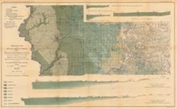
- Subject:
- Geographic Subject: Sullivan County (Ind.), Geographic Subject: Greene County (Ind.), Topical Subject: Geology, Topical Subject: Coal, and Topical Subject: I...
- Creator:
- Ashley, Geo. H. (George Hall), 1866-1951 and Siebenthal, C. E. (Claude Ellsworth), 1869-1930
- Publisher:
- Indiana. Department of Geology and Natural Resources
- Date Created:
- 1899
- Identifier:
- VAC3073-M-00945
- Genre:
- Geological cross-sections and Geological maps
- Geographic Location:
- Coordinates: W0873900 W0864200 N0391530 N0385400
- Related URL:
- Catalog URL: https://iucat.iu.edu/catalog/18265344
- Abstract:
- Relief shown by spot heights. Includes map showing the location of coal locations, coal features, and railroads, as well as geological cross sections for sev...
- Call Number:
- G4093.S8H9 1898 .A84
- Caption:
- Imprint: Indianapolis, Ind. : Wm. B. Burford, [1899]
- Physical Description:
- Scale: Approximately 1:126,720. 2 miles = 1 inch. Vertical scale approximately 1:4,800. 1 inch = 400 feet and Dimensions: 48 x 78 cm
- Alternate Identifier:
- Alternate ID: 390726IP and Title Control Number: a18265344
- Persistent URL:
- https://purl.dlib.indiana.edu/iudl/images/VAC3073/VAC3073-M-00945
- Provenance:
- 23rd Annual Report (1898) / Indiana. Department of Geology and Natural Resources.
-
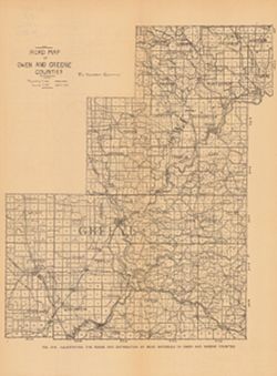
- Subject:
- Geographic Subject: Owen County (Ind.), Topical Subject: Macadam roads, Geographic Subject: Greene County (Ind.), Topical Subject: IGS Annual Reports, Topica...
- Publisher:
- Indiana. Department of Geology and Natural Resources
- Date Created:
- 1906
- Identifier:
- VAC3073-M-00739
- Genre:
- Geological maps and Thematic maps
- Geographic Location:
- Coordinates: W0871431 W0863820 N0392826 N0385418
- Related URL:
- Catalog URL: https://iucat.iu.edu/catalog/18299126
- Abstract:
- Alternate title: Illustrating the roads and distribution of road materials in Owen and Greene counties. At head of alternate title: Fig. 51A. Shows macadam q...
- Call Number:
- G4093.O8P2 1905 .R6
- Caption:
- Imprint: [Indianapolis] : [Indiana Dept. of Geology and Natural Resources], [1906]
- Physical Description:
- Dimensions: 30 x 26 cm and Scale: Approximately 1:216,000
- Alternate Identifier:
- Alternate ID: 390726IP and Title Control Number: a18299126
- Persistent URL:
- https://purl.dlib.indiana.edu/iudl/images/VAC3073/VAC3073-M-00739
- Provenance:
- 30th Annual Report (1905) / Indiana. Department of Geology and Natural Resources.
-

- Subject:
- Topical Subject: Limestone, Geographic Subject: Owen County (Ind.), Geographic Subject: Bloomington Region (Ind.), Geographic Subject: Greene County (Ind.), ...
- Creator:
- Indiana. Department of Geology and Natural Resources
- Publisher:
- Indiana. Department of Geology and Natural Resources
- Date Created:
- 1914
- Identifier:
- VAC3073-M-00351
- Genre:
- Topographic maps, Quadrangle maps, and Geological maps
- Geographic Location:
- Coordinates: W0864500 W0863000 N0391500 N0390000
- Related URL:
- Catalog URL: https://iucat.iu.edu/catalog/4896690
- Abstract:
- Relief shown by contours and spot heights. Contour interval 20 feet. Shows limestone locations in a portion of Monroe County and small portions of Owen and G...
- Call Number:
- G4093 .M7C5 1914 .I6
- Caption:
- Imprint: [Indianapolis] : Indiana Dept. of Geology [and Natural Resources], [1915] and Imprint: [Indianapolis] : [Wm. B. Burford], [1915]
- Physical Description:
- Dimensions: 45 x 35 cm and Scale: 1:62,500
- Alternate Identifier:
- Title Control Number: a4896690 and Alternate ID: 390726IP
- Persistent URL:
- https://purl.dlib.indiana.edu/iudl/images/VAC3073/VAC3073-M-00351
- Provenance:
- 39th Annual Report (1914) / Indiana. Department of Geology and Natural Resources.
