Search Constraints

You searched for: Publisher Indiana. Department of Geology and Natural Resources Remove constraint Publisher: Indiana. Department of Geology and Natural Resources Subject Topical Subject: Geology, Stratigraphic--Silurian Remove constraint Subject: Topical Subject: Geology, Stratigraphic--Silurian
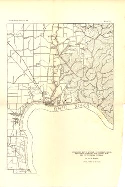
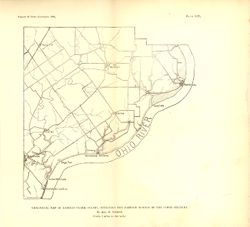
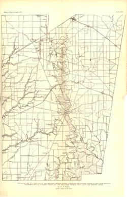
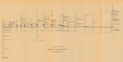
Search Results

  • Geological map of middle and eastern Jefferson County, outlining the eastern border of the upper Silurian
  • Geological map of eastern Clark County, outlining the eastern border of the upper Silurian
  • Geological map of Ripley County and adjacent Decatur County, outlining the eastern border of the upper Silurian (excepting east of Laughery Creek), and also the lower Silurian areas along the western creeks
  • Geological map of eastern Jennings County and adjacent Decatur County, outlining the lower Silurian areas in the bottoms of streams
  • A map of the counties of Dearborn, Ohio, Switzerland, Jefferson and Ripley showing the location of sections and collecting localities and the boundary between the Ordovician and Silurian systems
  • Map of the distribution of the Waldron shale in Decatur, Rush, Shelby, and Bartholomew counties, [Indiana]
  • A series of sections from Madison to Richmond, Indiana : showing the horizon of the base of the Saluda formation