
Search Constraints
You searched for:
Publisher
Indiana. Department of Geology and Natural Resources
Remove constraint Publisher: Indiana. Department of Geology and Natural Resources
Search Results
-
- Subject:
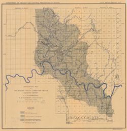
- Topical Subject: Abandoned quarries, Geographic Subject: Lawrence County (Ind.), Topical Subject: Limestone, Topical Subject: Geology, and Topical Subject: I...
- Creator:
- Siebenthal, C. E. (Claude Ellsworth), 1869-1930
- Publisher:
- Indiana. Department of Geology and Natural Resources
- Date Created:
- 1908
- Identifier:
- VAC3073-M-00256
- Genre:
- Geological maps
- Geographic Location:
- Coordinates: W0864110 W0861629 N0385940 N0383929
- Related URL:
- Catalog URL: https://iucat.iu.edu/catalog/18307475
- Abstract:
- Also shows locations of Mitchell and Harrodsburg limestones as well as abandoned quarries in Lawrence County and small parts of Orange, Washington, and Jacks...
- Call Number:
- G4093.L5H5 1907 .S5
- Caption:
- Imprint: [Indianapolis] : [Indiana Dept. of Geology and Natural Resources], [1908]
- Physical Description:
- Dimensions: 32 x 31 cm and Scale: Approximately 1:126,720. 2 miles = 1 inches
- Alternate Identifier:
- Title Control Number: a18307475 and Alternate ID: 390726IP
- Persistent URL:
- https://purl.dlib.indiana.edu/iudl/images/VAC3073/VAC3073-M-00256
- Provenance:
- 32nd Annual Report (1907) / Indiana. Department of Geology and Natural Resources.
-
- Subject:
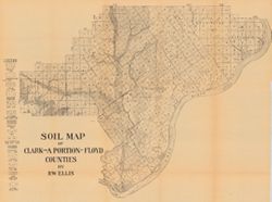
- Topical Subject: Soils, Geographic Subject: Clark County (Ind.), and Geographic Subject: Floyd County (Ind.)
- Creator:
- Ellis, R. W. (Robert W.)
- Publisher:
- Indiana. Department of Geology and Natural Resources
- Date Created:
- 1908
- Identifier:
- VAC3073-M-00249
- Genre:
- Thematic maps
- Geographic Location:
- Coordinates: W0855940 W0852455 N0383624 N0381601
- Related URL:
- Catalog URL: https://iucat.iu.edu/catalog/16152110
- Abstract:
- Detached from: A soil survey of Clark, Floyd, and Harrison counties / Robert W. Ellis. In Indiana Department of Geology and Natural Resources thirty-second a...
- Call Number:
- G4093.C4J3 1907 .E4
- Caption:
- Imprint: [Indianapolis] : [Indiana Department of Geology and Natural Resources], [1908]
- Physical Description:
- Dimensions: 49 x 64 cm and Scale: Approximately 1:90,000
- Alternate Identifier:
- Title Control Number: a16152110 and Alternate ID: 390726IP
- Persistent URL:
- https://purl.dlib.indiana.edu/iudl/images/VAC3073/VAC3073-M-00249
- Provenance:
- 32nd Annual Report (1907) / Indiana. Department of Geology and Natural Resources.
-
- Subject:
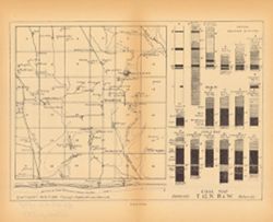
- Topical Subject: Geology, Stratigraphic, Topical Subject: Coalfields, Topical Subject: IGS Annual Reports, Geographic Subject: Clay County (Ind.), Topical Su...
- Publisher:
- Indiana. Department of Geology and Natural Resources
- Date Created:
- 1899
- Identifier:
- VAC3073-M-00248
- Genre:
- Geological cross-sections, Index maps, and Geological maps
- Geographic Location:
- Coordinates: W0870823 W0870225 N0393036 N0392623
- Related URL:
- Catalog URL: https://iucat.iu.edu/catalog/18214672
- Abstract:
- Caption title: East-west section through Hoosierville and Asherville. Relief shown by profile. Index map showing locations of coal fields around Hoosierville...
- Call Number:
- G4093.C5H9 1898 .C63
- Caption:
- Imprint: [Indianapolis] : [Indiana Department of Geology and Natural Resources], [1899]
- Physical Description:
- Dimensions: 23 x 28 cm and Scale: Approximately 1:63,360
- Alternate Identifier:
- Alternate ID: 390726IP and Title Control Number: a18214672
- Persistent URL:
- https://purl.dlib.indiana.edu/iudl/images/VAC3073/VAC3073-M-00248
- Provenance:
- 23rd Annual Report (1898) / Indiana. Department of Geology and Natural Resources.
-
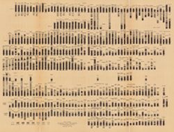
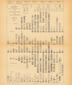
Coal chart : Indiana measures showing thickness, partings, roof and floor of the principal coal beds
- Subject:
- Topical Subject: Coal, Geographic Subject: Indiana, Topical Subject: Startigraphic correlation, Topical Subject: Geology, Stratigraphic, and Topical Subject:...
- Creator:
- Ashley, Geo. H. (George Hall), 1866-1951
- Publisher:
- Indiana. Department of Geology and Natural Resources
- Date Created:
- 1909
- Identifier:
- VAC3073-M-00243
- Genre:
- Geological cross-sections
- Geographic Location:
- Coordinates: W0880500 W0844700 N0414500 N0374600
- Related URL:
- Catalog URL: https://iucat.iu.edu/catalog/18307674
- Abstract:
- Includes several hundred stratigraphic columns showing coal measurements for sites across Indiana and correlation lines. Detached from: The coal deposits ...
- Call Number:
- G4091.C57 1907 .C63
- Caption:
- Imprint: [Indianapolis] : [Indiana Department of Geology and Natural Resources], [1909]
- Physical Description:
- Dimensions: 41 x 54 cm and Scale: Horizontal scale not given. Vertical scale approximately 1:12. 1 inch = 8 feet
- Alternate Identifier:
- Title Control Number: a18307674 and Alternate ID: 390726IP
- Persistent URL:
- https://purl.dlib.indiana.edu/iudl/images/VAC3073/VAC3073-M-00243
- Provenance:
- 33rd Annual Report (1908) / Indiana. Department of Geology and Natural Resources.
-
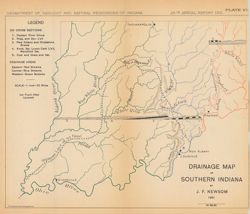
- Subject:
- Topical Subject: Geology, Stratigraphic, Topical Subject: IGS Annual Reports, Geographic Subject: Indiana, and Topical Subject: Watersheds
- Creator:
- Newsom, John F. (John Flesher), 1869-1928
- Publisher:
- Indiana. Department of Geology and Natural Resources
- Date Created:
- 1902
- Identifier:
- VAC3073-M-00234
- Genre:
- Thematic maps and Geological cross-sections
- Geographic Location:
- Coordinates: W0880500 W0844700 N0395100 N0374600
- Related URL:
- Catalog URL: https://iucat.iu.edu/catalog/18279215
- Abstract:
- Shows eastern, central, and western drainage areas in southern Indiana, the southern limit of the ice front after Leverett, and geological cross-sections in ...
- Call Number:
- G4091.C315 1901 .N49
- Caption:
- Imprint: Indianapolis, Ind. : Wm. B. Burford, Lith., [1902]
- Physical Description:
- Dimensions: on sheet 22 x 26 cm and Scale: Approximately 1:1,267,200. 1 inch = 20 miles
- Alternate Identifier:
- Alternate ID: 390726IP and Title Control Number: a18279215
- Persistent URL:
- https://purl.dlib.indiana.edu/iudl/images/VAC3073/VAC3073-M-00234
- Provenance:
- 26th Annual Report (1901) / Indiana. Department of Geology and Natural Resources.
-
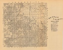
- Subject:
- Geographic Subject: Orange County (Ind.) and Topical Subject: Soils
- Creator:
- Indiana. Department of Geology and Natural Resources
- Publisher:
- Indiana. Department of Geology and Natural Resources
- Date Created:
- 1908
- Identifier:
- VAC3073-M-00221
- Genre:
- Thematic maps
- Geographic Location:
- Coordinates: W0864059 W0861827 N0384119 N0382346
- Related URL:
- Catalog URL: https://iucat.iu.edu/catalog/16095946
- Abstract:
- Detached from: A soil survey of Monroe, Brown, Lawrence, Martin, Orange, Washington and Jackson counties / by Chas. W. Shannon and L. C. Snider. In Indiana D...
- Call Number:
- G4093.O6J3 1907 .I53
- Caption:
- Imprint: [Indianapolis] : [Indiana Department of Geology and Natural Resources], [1908]
- Physical Description:
- Dimensions: 27 x 27 cm and Scale: Approximately 1:126,720
- Alternate Identifier:
- Title Control Number: a16095946 and Alternate ID: 390726IP
- Persistent URL:
- https://purl.dlib.indiana.edu/iudl/images/VAC3073/VAC3073-M-00221
- Provenance:
- 32nd Annual Report (1907) / Indiana. Department of Geology and Natural Resources.
-
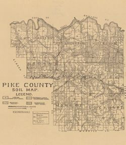
- Subject:
- Geographic Subject: Pike County (Ind.) and Topical Subject: Soils
- Creator:
- Shannon, M. E. and Shannon, C. W. (Charles William), 1879-1934
- Publisher:
- Indiana. Department of Geology and Natural Resources
- Date Created:
- 1910
- Identifier:
- VAC3073-M-00173
- Genre:
- Thematic maps
- Geographic Location:
- Coordinates: W0872746 W0870419 N0383308 N0381351
- Related URL:
- Catalog URL: https://iucat.iu.edu/catalog/16123837
- Abstract:
- Shows railroads and 3 classes of roads. "U.S. topographic sheets, state geological maps, field work 1909." Detached from: A soil survey of Vande...
- Call Number:
- G4093.P4J3 1909 .S5
- Caption:
- Imprint: [Indianapolis] : [Indiana Department of Geology and Natural Resources], [1910]
- Physical Description:
- Scale: Approximately 1:126,720 and Dimensions: 37 x 32 cm
- Alternate Identifier:
- Title Control Number: a16123837 and Alternate ID: 390726IP
- Persistent URL:
- https://purl.dlib.indiana.edu/iudl/images/VAC3073/VAC3073-M-00173
- Provenance:
- 34th Annual Report (1909) / Indiana. Department of Geology and Natural Resources.
-
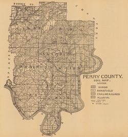
- Subject:
- Geographic Subject: Perry County (Ind.) and Topical Subject: Soils
- Creator:
- Indiana. Department of Geology and Natural Resources
- Publisher:
- Indiana. Department of Geology and Natural Resources
- Date Created:
- 1909
- Identifier:
- VAC3073-M-00164
- Genre:
- Thematic maps
- Geographic Location:
- Coordinates: W0864853 W0862548 N0381558 N0375029
- Related URL:
- Catalog URL: https://iucat.iu.edu/catalog/16123915
- Abstract:
- Shows school houses, public roads, and railroads. Detached from: A soil survey of four counties of southern Indiana / Chas. W. Shannon and L.C. Snider. In...
- Call Number:
- G4093.P3J3 1908 .I53
- Caption:
- Imprint: [Indianapolis] : [Indiana Department of Geology and Natural Resources], [1909]
- Physical Description:
- Dimensions: 41 x 38 cm and Scale: Approximately 1:126,720
- Alternate Identifier:
- Alternate ID: 390726IP and Title Control Number: a16123915
- Persistent URL:
- https://purl.dlib.indiana.edu/iudl/images/VAC3073/VAC3073-M-00164
- Provenance:
- 33rd Annual Report (1908) / Indiana. Department of Geology and Natural Resources.
-
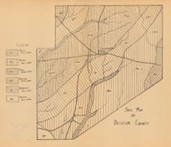
- Subject:
- Topical Subject: IGS Annual Reports, Geographic Subject: Decatur County (Ind.), and Topical Subject: Loam soils
- Publisher:
- Indiana. Department of Geology and Natural Resources
- Date Created:
- 1908
- Identifier:
- VAC3073-M-00136
- Genre:
- Geological maps
- Geographic Location:
- Coordinates: W0854116 W0851747 N0392712 N0390750
- Related URL:
- Catalog URL: https://iucat.iu.edu/catalog/18307561
- Abstract:
- Detached from: A soil survey of Decatur, Jennings, Jefferson, Ripley, Dearborn, Ohio, and Switzerland counties, Indiana / L.C. Ward. In Indiana Dept. of Geol...
- Call Number:
- G4093.D4J3 1907 .S6
- Caption:
- Imprint: [Indianapolis] : [Indiana Department of Geology and Natural Resources], [1908]
- Physical Description:
- Dimensions: on sheet 23 x 26 cm and Scale: Scale not given.
- Alternate Identifier:
- Title Control Number: a18307561 and Alternate ID: 390726IP
- Persistent URL:
- https://purl.dlib.indiana.edu/iudl/images/VAC3073/VAC3073-M-00136
- Provenance:
- 32nd Annual Report (1907) / Indiana. Department of Geology and Natural Resources.
-
- Subject:
- Topical Subject: Geology, Stratigraphic, Topical Subject: Startigraphic correlation, Topical Subject: Coal, Geographic Subject: Indiana, and Topical Subject:...
- Publisher:
- Indiana. Department of Geology and Natural Resources
- Date Created:
- 1899
- Identifier:
- VAC3073-M-00119
- Genre:
- Geological cross-sections
- Geographic Location:
- Coordinates: W0880500 W0844700 N0414500 N0374600
- Related URL:
- Catalog URL: https://iucat.iu.edu/catalog/18276213
- Abstract:
- Includes stratigraphic columns, correlation lines, and depth measurements. Plate IX. Columnar sections included in this diagram are also shown accompanying a...
- Call Number:
- G4091.H9 1898 .C43
- Caption:
- Imprint: [Indianapolis] : [Indiana Department of Geology and Natural Resources], [1899]
- Physical Description:
- Dimensions: 27 x 23 cm and Scale: Scale not given.
- Alternate Identifier:
- Title Control Number: a18276213 and Alternate ID: 390726IP
- Persistent URL:
- https://purl.dlib.indiana.edu/iudl/images/VAC3073/VAC3073-M-00119
- Provenance:
- 23rd Annual Report (1898) / Indiana. Department of Geology and Natural Resources.
