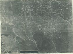
Michigan, Minnesota, Indians of North America, Wisconsin, American Indians, and United States--Maps
Series:
GLOVE - Local and Regional Maps
Date Created:
1851
Identifier:
VAD5944-000069
Abstract:
Geological map of Wisconsin, Iowa and Minnesota: Exhibiting, also, the extension of the Iowa coal-field into Missouri, and its relation to the Illinois coal-...
Bloomington - Indiana University Museum of Archaeology and Anthropology 416 North Indiana Avenue Bloomington, IN 47408 Contact at iumaa@indiana.edu, 812-855-6873
Bloomington - Indiana University Museum of Archaeology and Anthropology 416 North Indiana Avenue Bloomington, IN 47408 Contact at iumaa@indiana.edu, 812-855-6873
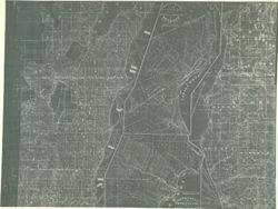
American Indians, United States--Maps, Illinois, Michigan, Indians of North America, and Wisconsin
Series:
GLOVE - Local and Regional Maps
Date Created:
1847
Identifier:
VAD5944-000060
Abstract:
A geological map of Isle Royale to Lake Superior reduced from the maps made pursuant to Act of Congress approved March 1st 1847. By Charles T. Jackson, J.W....
Bloomington - Indiana University Museum of Archaeology and Anthropology 416 North Indiana Avenue Bloomington, IN 47408 Contact at iumaa@indiana.edu, 812-855-6873
Bloomington - Indiana University Museum of Archaeology and Anthropology 416 North Indiana Avenue Bloomington, IN 47408 Contact at iumaa@indiana.edu, 812-855-6873
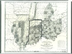
Illinois, Indiana, Ohio, Indians of North America, American Indians, United States--Maps, and Michigan
Series:
GLOVE - Local and Regional Maps
Creator:
Vance, D. H. (David H.)
Date Created:
1825
Identifier:
VAD5944-000034
Abstract:
The State of OHIO is about 220 miles in Extent from East to West and averages 184 miles from North to South. Area 40,000 square miles or 25,600,000 acres. ...
Bloomington - Indiana University Museum of Archaeology and Anthropology 416 North Indiana Avenue Bloomington, IN 47408 Contact at iumaa@indiana.edu, 812-855-6873