Gray, Henry Hamilton, 1922-, Wier, Charles E. (Charles Eugene), 1921-, Indiana. Geological Survey, Wayne, William J. (William John), 1922-, and Illinois Stat...
Publisher:
Indiana. Geological Survey
Date Created:
1970
Identifier:
VAC3073-M-01257
Genre:
Quadrangle maps, Geological maps, and Geological cross-sections
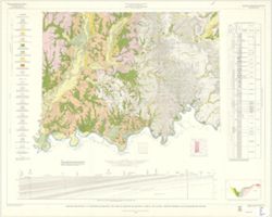
By Henry H. Gray, William J. Wayne, and Charles E. Wier , Indiana Geological Survey, in cooperation with Illinois State Geological Survey. Transverse Mercato...
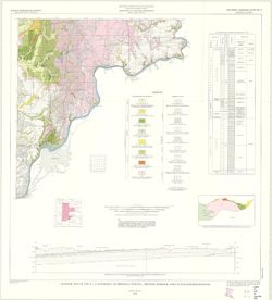
By Henry H. Gray. Compiled by H. H. Gray and A. M. Burger. Drafted by J. R. Tolen. Base map modified from Army Map Service Map NJ16-6, 1964. Transverse Merca...
By Henry H. Gray, William J. Wayne, and Charles E. Wier , Indiana Geological Survey, in cooperation with Illinois State Geological Survey. Transverse Mercato...
Call Number:
G4091.C5 s250 .I5 Vincennes
Caption:
Imprint: [Bloomington, Ind.] : The Survey, 1970
Physical Description:
Dimensions: 76 x 102 cm and Scale: 1:250,000. Vertical scale approximately 1:11,500
Indiana. Geological Survey, Bleuer, N. K. (Ned Kermit), 1943-, Lineback, Jerry A. (Jerry Alvin), Hill, John R,, Gray, Henry Hamilton, 1922-, and Illinois Sta...
Publisher:
Indiana. Geological Survey
Date Created:
1979
Identifier:
VAC3073-M-01251
Genre:
Quadrangle maps, Geological maps, and Geological cross-sections
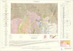
Indianapolis sheet. 1979 edition. Transverse Mercator projection. Geology compiled by H. H. Gray (Indiana) and J. A. Lineback (Illinois) from published and o...
Schneider, Allan F. (Allan Frank), 1926-, Gooding, Ansel Miller, Forsyth, Jane L. (Jane Louise), 1921-, Gray, Henry Hamilton, 1922-, and Indiana. Geological ...
Publisher:
Indiana. Geological Survey
Date Created:
1972
Identifier:
VAC3073-M-01245
Genre:
Geological maps, Geological cross-sections, and Quadrangle maps
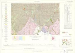
By Henry H. Gray, Jane L. Forsyth, Allan F. Schneider, and Ansel M. Gooding. Transverse Mercator projection. "Base map modified from Army Map Service, M...